Near Damloup in Meuse, Alsace, Lorraine, Champagne-Ardenne, France — Western Europe
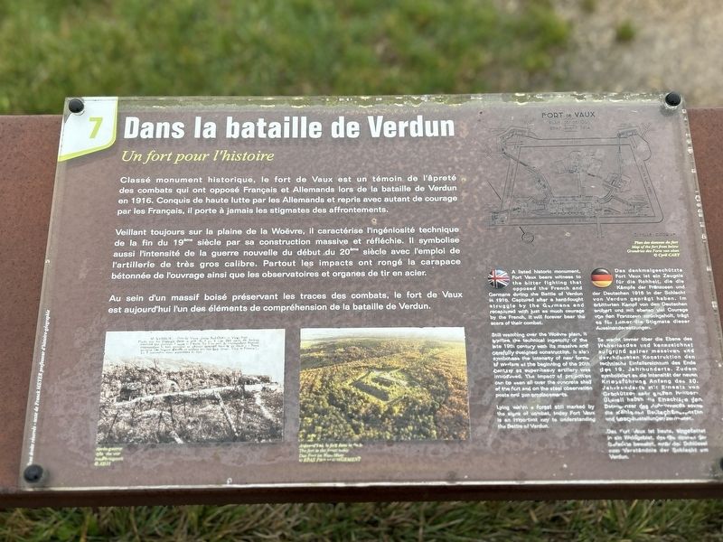
Dans la bataille de Verdun
Un fort pour l'histoire
Photographed by Steve Stoessel, November 18, 2024
1. Dans la bataille de Verdun Marker

Veillant toujours sur la plaine de la Woëvre, il caractérise l'ingéniosité technique de la fin du 19m siècle par sa construction massive et réfléchie. Il symbolise aussi l'intensité de la guerre nouvelle du début du 20àm siècle avec l'emploi de l'artillerie de très gros calibre. Partout les impacts ont rongé la carapace bétonnée de l'ouvrage ainsi que les observatoires et organes de tir en acier.
Au sein d'un massif boisé préservant les traces des combats, le fort de Vaux est aujourd'hui l'un des éléments de compréhension de la bataille de Verdun.
this page online
Still watching over the Woëvre plain, it typifies the technical ingenuity of the late 19th century with its massive and carefully designed construction. It also symbolizes the intensity of new forms of warfare at the beginning of the 20th Century as super-heavy artillery was introduced. The impact of projectiles can be seen all over the concrete shell of the fort and on the steel observation posts and gun emplacements. Lying within a forest still marked by the signs of combat, today Fort Vaux is an important key to understanding the Battle of Verdun.
Es wacht immer aber die Ebene des Waberlandes und kennzeichnet aufgrund seiner massiven und durchdachten Konstruktion den technische Einfallsreichtum des Ende des 19. Jahrhunderts. Zudem symbolisiert es die Intensität der neuen Kriegsführung
Photographed by Steve Stoessel, November 18, 2024
2. Dans la bataille de Verdun Marker
Das Fort Vaux ist heute, eingefettet in ein Waldgebiet, des die Spuren der Gefechte bewehrt, maß die Schlüssel zum Verständnis der Schlacht um Verdun. (Marker Number 7.)
Topics. This historical marker is listed in this topic list: Forts and Castles. A significant historical year for this entry is 1916.
Location. 49° 12.015′ N, 5° 28.213′ E. Marker is near Damloup, Grand Est (Alsace, Lorraine, Champagne-Ardenne), in Meuse. It can be reached from Grand Est Route 913a 2.6 kilometers north of Route 913. Touch for map. Marker is in this post office area: Damloup, Grand Est 55400, France. Touch for directions.

Regionally, it is in the North Atlantic Region, Europe, the European Union, Atlantic Europe, the Schengen Area, Western Europe, a coastal Mediterranean country, and the Western World. Historically, it finds itself in what was once a French colony, the Roman Empire, and specifically
Photographed by Steve Stoessel, November 18, 2024
3. Dans la bataille de Verdun Marker
Other nearby markers. At least 8 other markers are within walking distance of this marker: De sa construction à la bataille de Verdun (here, next to this marker); a different marker also named Dans la bataille de Verdun (here, next to this marker); a different marker also named Dans la bataille de Verdun (a few steps from this marker); a different marker also named De sa construction à la bataille de Verdun (a few steps from this marker); Pigeon de Verdun (a few steps from this marker); a different marker also named Dans la bataille de Verdun (a few steps from this marker); a different marker also named De sa construction à la bataille de Verdun (a few steps from this marker); Les Défenseurs du Fort de Vaux (within shouting distance of this marker). Touch for a list and map of all markers in Damloup.
Credits. This page was last revised on February 18, 2025. It was originally submitted on February 6, 2025, by Steve Stoessel of Niskayuna, New York. This page has been viewed 96 times since then and 10 times this year. Photos: 1, 2, 3. submitted on February 6, 2025, by Steve Stoessel of Niskayuna, New York.
