Near Damloup in Meuse, Alsace, Lorraine, Champagne-Ardenne, France — Western Europe
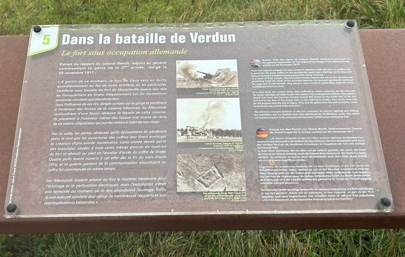
Dans la bataille de Verdun
Le fort sous occupation allemande
Photographed by Steve Stoessel, November 18, 2024
1. Dans la bataille de Verdun Marker

« A partir de ce moment, le fort de Vaux sera en butte quotidiennement au feu de notre artillerie, et, en particulier, l'artillerie sous tourelle du fort de Moulainville jouera son rôle de flanquement en tirant fréquemment sur les formations ennemies circulant aux abords du fort. Sous l'influence de ces tirs, dirigés surtout sur la gorge et pénétrant à l'intérieur des locaux de la caserne bétonnée, les Allemands renforcèrent d'une façon sérieuse la façade de cette caserne. Ils placèrent à l'intérieur même des locaux une masse de terre de six mètres d'épaisseur qui put les mettre à l'abri de nos coups. Par la suite, les pertes sérieuses qu'ils éprouvaient en pénétrant dans le fort par les ouvertures des coffres leur firent envisager la création d'une entrée souterraine. Cette entrée devait partir des tranchées situées à trois cents mètres environ du nord-est du fort et aboutir au pied de l'escalier d'accès du coffre de droite. Quatre puits furent ouverts à cet effet dès la fin du mois d'août
this page online
"From that moment onwards, Fort Vaux would be exposed to dally fire from our artillery and, In particular, the turret artillery of Fort Moulainville would play a flanking role by frequently firing on the enemy formations moving around the vicinity of the fort. As a result of these attacks, directed predominantly towards the rear of the structure and penetrating inside the rooms of the armoured barracks, the Germans significantly reinforced the outer wall of said barracks. They placed a layer of earth 6 metres thick inside the rooms to shelter them from our shots.
At a later date, the serious losses they suffered as solders entering the fort through the bunker openings, led them to plan the creation of an underground entrance. This entrance would start from the trenches located around 300 metres to the north-east of the fort and end at the foot of the access stairs to the right-hand bunker. Four shafts were dug for this purpose from the end of August 1916, and the gallery from the communication centre to the bunker was started at the same time.
The Germans brought material to the fort necessary for electric lighting and drilling, but installation was not finished when they abandoned the fortifications. Lastly, they carried out numerous repairs to the armoured communication infrastructure during their stay."
„Ab diesem Zeitpunkt ist das Fort Vaux unserem täglichen Artilleriebeschuss ausgesetzt und insbesondere der Artillerie des Geschützturms des Forts Moulainville spielt durch den häufigen Beschuss der feindlichen Formationen im Vorgelände des Forts eine wichtige - flankierende Rolle.
In Folge dieses Beschusses, der vor allem auf die Schlucht gerichtet war und in das Innere der betonierten Kaserne eindrang, wurde die Fassade dieser Kaserne von den Deutschen massiv verstärkt. Sie errichteten im Inneren dieser Räumlichkeiten einen sechs Meter dicken Erdwall, um sich vor unseren Angriffen zu schützen.
Angesichts der erheblichen Verluste, die sie beim Eindringen in das Fort durch die Kofferöffnungen erlitten haben, machten sie sich an den Bau eines unterirdischen Eingangs. Dieser Eingang sollte von den Gräben etwa dreihundert Meter nordöstlich des Forts ausgehen und am Fuße der Zugangstreppe des rechten Grebenkorrers erden. Zu lesem Zweck wurden ab Ende August 1916 vier Schache geöffnet und gleichzeitig der Tunnel vom Verbindungsgang zum Koffer in Angriff genommen.
Die Deutschen hatten das nötige Material für die elektrische Beleuchtung und Bohrungsarbeiter in dos Fort geschart, jedoch war die Installation zu dem Zeltpunkt, an dem sie das Work aufgaben, noch nicht abgeschlossen. Und schließlich haben sie während ihres Aufenthaltesgebietliche Reparaturen an den betonierten Verbindungsgänge durchgeführt."
Topics. This historical marker is listed in this topic list: Forts and Castles. A significant historical date for this entry is November 23, 1917.
Location. 49° 12.019′ N, 5° 28.201′ E. Marker is near Damloup, Grand Est (Alsace, Lorraine, Champagne-Ardenne), in Meuse. It can be reached from Grand Est Route 913a 2.6 kilometers north of Route 913. Touch for map. Marker is in this post office area: Damloup, Grand Est 55400, France. Touch for directions.

Regionally, it is in the North Atlantic Region, Europe, the European Union, Atlantic Europe, the Schengen Area, Western Europe, a coastal Mediterranean country, and the Western World. Historically, it finds itself in what was once a French colony, the Roman Empire, and specifically the Holy Roman Empire.
Other nearby markers. At least 8 other markers are within walking distance of this marker: De sa construction à la bataille de Verdun (here, next to this marker); a different marker also named Dans la bataille de Verdun (a few steps from this marker); a different marker also named De sa construction à la bataille de Verdun (a few steps from this marker); a different marker also named Dans la bataille de Verdun (a few steps from this marker); a different marker also named Dans la bataille de Verdun (a few steps from this marker); a different marker also named De sa construction à la bataille de Verdun (a few steps from this marker); Dans la Bataille de Verdun (a few steps from this marker); a different marker also named De sa construction à la bataille de Verdun (a few steps from this marker). Touch for a list and map of all markers in Damloup.
Credits. This page was last revised on February 17, 2025. It was originally submitted on February 6, 2025, by Steve Stoessel of Niskayuna, New York. This page has been viewed 91 times since then and 13 times this year. Photo 1. submitted on February 6, 2025, by Steve Stoessel of Niskayuna, New York.
