Near Damloup in Meuse, Alsace, Lorraine, Champagne-Ardenne, France — Western Europe
De sa construction à la bataille de Verdun
1888-1889 : le fort bétonné
Photographed by Steve Stoessel, November 18, 2024
1. De sa construction à la bataille de Verdun Marker

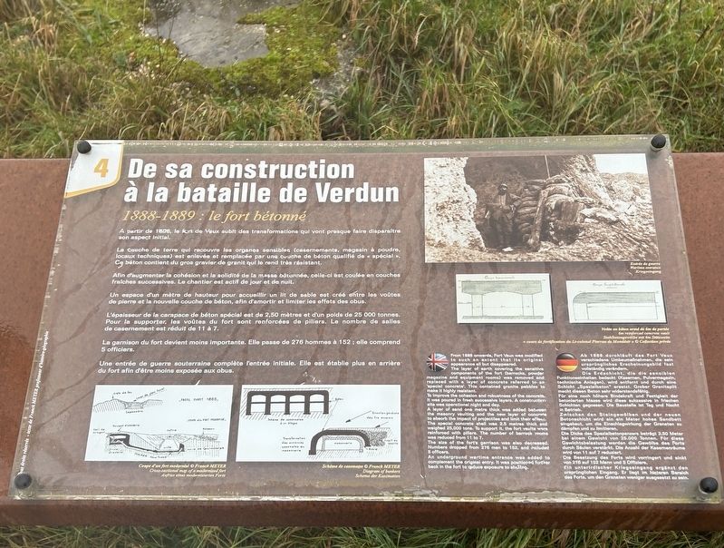
A partir de 1888, le fort de Vaux subit des transformations qui vont presque faire disparaître son aspect initial.
La Couche de terre qui recouvre les organes sensibles (casernements, magasin à poudre, locaux techniques) est enlevée et remplacée par une couche de béton qualifié de « spécial ». Ce béton contient du gros gravier de granit qui le rend très résistant.
Afin d'augmenter la cohésion et la solidité de la masse bétonnée, celle-ci est coulée en couches fraîches successives. Le chantier est actif de jour et de nuit.
Un espace d'un mètre de hauteur pour accueillir un lit de sable est créé entre les voûtes de pierre et la nouvelle couche de béton, afin d'amortir et limiter les effets des obus.
,br> L'épaisseur de la carapace de béton spécial est de 2,50 mètres et d'un poids de 25 000 tonnes. Pour la supporter, les voûtes du fort sont renforcées de piliers. Le nombre de salles de casernement est réduit de 11 à 7.
La garnison du fort devient moins importante. Elle passe de 276 hommes à 152; elle comprend 5 officiers.
Une entrée de guerre souterraine complète l'entrée initiale. Elle est établie plus en arrière
this page online
The layer of earth covering the sensitive components of the fort (barracks, powder magazine and equipment rooms) was removed and replaced with a layer of concrete referred to as 'special concrete. This contained granite pebbles to make it highly resistant.
To improve the cohesion and robustness of the concrete, it was poured in fresh successive layers. A construction site was operational night and day.
A layer of sand one metre thick was added between the masonry vaulting and the new layer of concrete to absorb the impact of projectiles and limit their effects. The special concrete shell was 2.5 metres thick and weighed 25,000 tons. To support it, the fort vaults were reinforced with pillars. The number of barrack rooms was reduced from 11 to 7.
The size of the fort's garrison was also decreased. Numbers dropped from 276 men to 152, and included 5 officers.
An underground wartime entrance was added to complement the original entry. It was positioned further back in the fort
Photographed by Steve Stoessel, November 18, 2024
2. De sa construction à la bataille de Verdun Marker
Die Erdschicht, die die sensiblen Funktionseinheiten bedeckt (Kasernen, Pulvermagazin, technische Anlagen), wird entfernt und durch eine Schicht „Spezialbeton" ersetzt. Grober Granitsplit macht diesen Beton sehr widerstandsfähig.
Für eine noch höhere Bindekraft und Festigkeit der betonierten Masse wird diese sukzessive in frischen Schichten gegossen. Die Baustelle Ist Tag und Nacht in Betrieb.
Zwischen den Steingewölben und der neuen Betonschicht wird ein ein Meter hohes Sandbett eingebaut, um die Einschlagwirkung der Granaten zu dämpfen und zu limitieren.
Die Dicke des Spezialbetonpanzers beträgt 2,50 Meter bei einem Gewicht von 25.000 Tonnen. Für diese Gewichtsbelastung werden die Gewölbe des Forts durch Säulen verstärkt. Die Anzahl der Kasernenräume wird von 11 auf 7 reduziert.
Die Besatzung des Forts wird verringert und sinkt von 276 auf 152 Mann und 5 Offiziere. ein unterirdischer Kriegseingang ergänzt den ursprünglichen Eingang. Er liegt im hinteren Bereich des
Photographed by Steve Stoessel, November 18, 2024
3. De sa construction à la bataille de Verdun Marker
Topics. This historical marker is listed in this topic list: Forts and Castles. A significant historical year for this entry is 1888.
Location. 49° 12.02′ N, 5° 28.194′ E. Marker is near Damloup, Grand Est (Alsace, Lorraine, Champagne-Ardenne), in Meuse. It can be reached from Grand Est Route 913a 2 kilometers north of Route 913. Marker is in Fort Vaux located at the end of D913a. Touch for map. Marker is in this post office area: Damloup, Grand Est 55400, France. Touch for directions.

Regionally, it is in the North Atlantic Region, Europe, the European Union, Atlantic Europe, the Schengen Area, Western Europe, a coastal Mediterranean country, and the Western World. Historically, it finds itself in what was once a French colony, the Roman Empire, and specifically the Holy Roman Empire.
Other nearby markers. At least 8 other markers are within walking distance of this marker: Dans la bataille de Verdun (here, next to this marker); a different marker also named De sa construction à la bataille de Verdun (here, next to this marker); a different marker also named De sa construction à la bataille de Verdun (here, next to this marker); a different marker also named Dans la bataille de Verdun (a few steps from this marker); Dans la Bataille de Verdun (a few steps from this marker); Les Défenseurs du Fort de Vaux (a few steps from this marker); a different marker also named De sa construction à la bataille de Verdun (a few steps from this marker); a different marker also named Dans la bataille de Verdun (a few steps from this marker). Touch for a list and map of all markers in Damloup.
Credits. This page was last revised on February 25, 2025. It was originally submitted on February 19, 2025, by Steve Stoessel of Niskayuna, New York. This page has been viewed 97 times since then and 13 times this year. Photos: 1, 2, 3. submitted on February 19, 2025, by Steve Stoessel of Niskayuna, New York.
