Zillebeke near Ypres in West-Vlaanderen, Flanders, Belgium — Northwestern Europe
The Bluff in the 'Palingbeek' provincial park
2014-18
| — | 100 jaar Groot Oorlog | — |
Photographed by Steve Stoessel, November 14, 2024
1. The Bluff in the 'Palingbeek' provincial park Marker

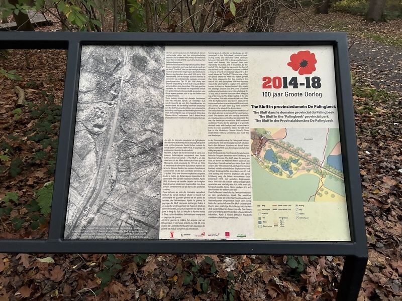
Binnen provinciedomein De Palingbeek bleven authentieke delen van het oorlogslandschap bewaard. Na de bittere mislukking van het kanaal leper-Komen (1864/1913) was het landschap hier helemaal vergraven.
Eind 1914 dwarste de frontlijn de kanaalsleuf. Britse troepen bezetten een hoge bult op de rand van de sleuf: “The Bluff”, één van de weinige plaatsen waar de geallieerden hoger lagen dan de Duitsers.
Daarom probeerden deze eind 1915 en in 1916 herhaaldelijk om de hoogte (Grosse Bastion) te veroveren via ondergrondse explosies en zware grondgevechten. Op 25 juli 1916 sloeg een enorme ontploffing de hele bult weg, de Britten antwoordden eind december 1916 met gerichte explosies. Na 1916 luwde het strijdtoneel omdat het gebied totaal ontoegankelijk geworden was. Beide legers groeven zich in op de flanken van de diepe kraters.
,br> Twee sluizen binnen het domein herinneren aan het mislukte kanaal. De westelijke sluis werd ingericht als een Brits hoofdkwartier en verbandpost. Na de oorlog bleef het landschap van the Bluff onveranderd. Door een uitgezochte inrichting met hagen en herdenkingsbomen kan men de frontlijnen
this page online
Deux écluses au sein du domaine rappellent l'échec du canal. L'écluse située à l'ouest fut aménagée en quartier général
Photographed by Steve Stoessel, November 14, 2024
2. The Bluff in the 'Palingbeek' provincial park Marker
Après la guerre, la colline fut acquise par un Britannique et demeura intacte. La Hill 60 et le cratère de Caterpillar font partie des paysages de guerre les mieux conservés du Westhoek.
The ruins of two locks in the park are reminders of the failed attempt to construct the Ieper-Komen canal. The western lock was used by the British as a headquarters and medical aid post. After the war, the landscape around the Bluff remained unaltered. Thanks to the planting of a specially devised route with hedges and remembrance trees, it is now possible to follow the old front line to the Molenbos (“Ravine Wood”). Three small British military cemeteries also mark this war landscape.
Ende 1914 querte die Frontlinie die Kanalschneise Britische Truppen besetzten eine Erhöhung am Rand der Schneise: The Bluff, einer der wenigen Orte, an denen die Alliierten höher lagen als die Deutschen. Deshalb versuchten diese Ende 1915 und im Jahr 1916 wiederholt, die Anhöhe (Grosse Bastion) mittels unterirdischer Explosionen und heftiger Bodengefechte zu erobern. Am 25. Juli 1916 schlug eine enorme Explosion die ganze Erhöhung weg, die Briten antworteten Ende Dezember 1916 mit gezielten Explosionen. Nach 1916 war das Gebiet völlig unzugänglich geworden war und eignete sich nicht mehr als Kriegsschauplatz. Beide Heere gruben sich auf den Flanken der tiefen Krater ein. Zwei Schleusen innerhalb der Domäne erinnem an den gescheiterten Kanal. Die westliche Schleuse wurde als britisches Hauptquartier und Verbandposten eingerichtet. Nach dem Krieg blieb die Landschaft von The Bluff unverändert. Durch eine prächtige Einrichtung mit Hecken und Gedenkbäumen kann man die Frontlinien zum und entlang dem Molenbos (Ravine Wood) erkunden. Auch 3 kleine britische Friedhöfe markieren diese Kriegslandschaft.
[Photo Captions]
Topics. This historical marker is listed in this topic list: War, World I. A significant historical date for this entry is July 25, 1916.
Location. 50° 48.886′ N, 2° 55.027′ E. Marker is near Ypres, Vlaanderen (Flanders), in West-Vlaanderen. It is in Zillebeke. It can be reached from Palingbeekstraat. Marker is on the park trail half a mile from the parking lot. Touch for map. Marker is at or near this postal address: Palingbeekstraat 18, Ypres, Vlaanderen 8902, Belgium. Touch for directions.

Regionally, it is in Europe, the European Union, Atlantic Europe, the Benelux Low Countries, the Schengen Area, Western Europe, and the Western World. Historically, it finds itself in what was once the Roman Empire and specifically also the Holy Roman Empire.
Other nearby markers. At least 8 other markers are within walking distance of this marker: De Ondergrondse Oorlog (a few steps from this marker); Kraterwand The Bluff 1916 (about 120 meters away, measured in a direct line); The Frontline at the Bluff, 1915 (about 150 meters away); Pierre Marchand Lucien Olivier (approx. 1.3 kilometers away); 15th Battalion Canadian Infantry (approx. 1.3 kilometers away); In Memory of the 14th Light Division (approx. 1.3 kilometers away); Hill 60 (approx. 1.3 kilometers away); 1st Australian Tunneling Company (approx. 1.3 kilometers away). Touch for a list and map of all markers in Ypres.
Credits. This page was last revised on February 20, 2025. It was originally submitted on February 19, 2025, by Steve Stoessel of Niskayuna, New York. This page has been viewed 137 times since then and 28 times this year. Photos: 1, 2. submitted on February 19, 2025, by Steve Stoessel of Niskayuna, New York.
