Zonnebeke in West-Vlaanderen, Flanders, Belgium — Northwestern Europe
Land of the Dead
Photographed by Steve Stoessel, November 12, 2024
1. Land of the Dead Marker

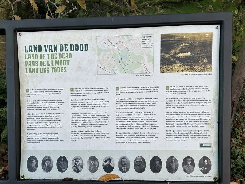
Land van de Dood
In 1917 is het kasteeldomein van Zonnebeke een oord van dood en vernieling. Wat ooit een oase van rust was, ontaardt door ongezien oorlogsgeweld in de hel op aarde.
Op 26 september 1917 bereiken geallieerden het compleet verwoeste Zonnebeke. Acht dagen later nemen ze de rest van het dorp in. Op 4 oktober hadden de Duitsers op hetzelfde moment een tegenaanval ingepland, 'Unternehmung Höhensturm'. De operatie draait uit op een catastrofe.
In Zonnebeke vallen tussen 26 september en 4 oktober 1917 duizenden doden. Vooral het Duitse Reserve-Infanterie- Regiment 212 lijdt hier buitengewoon hoge verliezen: meer dan 1.000 doden, gewonden en krijgsgevangenen. De meesten zijn destijds ter plaatse begraven. In het huidige kasteelpark zijn ruim 170 geallieerden gevonden, vooral Australiers en Britten. Het merendeel kon men niet identificeren.
Er zijn nagenoeg geen Duitse ontgravingsgegevens gekend. Van de meeste Duitsers die in Zonnebeke sneuvelden, kennen we de laatste rustplaats niet. Een minderheid wordt vandaag bij naam herdacht op een graf of vermistenmonument.
In 1917 the grounds
this page online
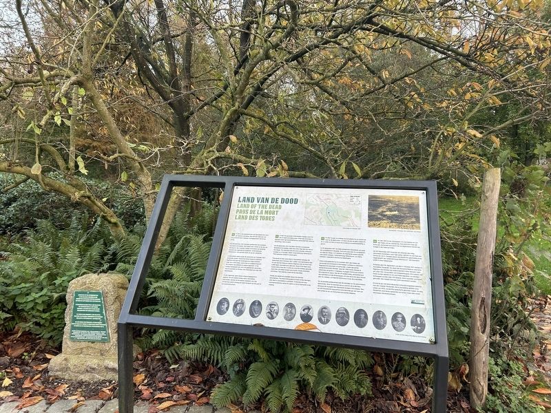
On 26 September 1917 the Allies reached a completely devastated Zonnebeke. Eight days later they took the rest of the village. The Germans had planned a counter-offensive to begin on 4 October, called 'Unternehmung Höhensturm'. That operation ended in catastrophe.
Thousands of men were killed in Zonnebeke between 26 September and 4 October 1917. Losses were particularly high for the German Reserve Infantry Regiment 212, at more than 1,000 dead, wounded and captured. Most of the dead were buried where they fell. In what are now the chateau grounds, more than 170 Allied troops were found, mostly Australian and British. The majority could not be identified.
Hardly any details are available about the German exhumations. The final resting place of most of the Germans who died in Zonnebeke is unknown. A minority are now commemorated by name on a grave, or on a memorial to the missing.
En 1917, le parc du château de Zonnebeke fut un endroit de mort et de
Photographed by Steve Stoessel, November 12, 2024
2. Land of the Dead Marker
Le 26 septembre 1917, les Alliés atteignirent Zonnebeke, qui avait été complètement dévastée. Huit jours plus tard, ils s'emparèrent du reste du village. Le 4 octobre, les Allemands avaient planifié une contre-attaque, 'Unternehmung Höhensturm', au même moment. L/opération tourna à la catastrophe.
Entre le 26 septembre et le 4 octobre 1917, des milliers de personnes succombèrent à Zonnebeke. Le Reserve-Infanterie-Regiment 212 allemand, en particulier, y subit des pertes extraordinairement élevées: plus de 1 000 morts, blessés et prisonniers de guerre. A l'époque, la plupart d'entre eux avaient été enterrés sur place. Plus de 170 soldats alliés, principalement des Australiens et des Britanniques, ont été retrouvés dans l'actuel parc du château. La majorité d'entre eux n'a pu être identifiée.
On ne possède pratiquement pas de données sur les exhumations allemandes. Nous ne sommes pas au courant de la dernière demeure de la plupart des Allemands tombés à Zonnebeke. Rien qu'une minorité est aujourd'hui commémorée par son nom sur une tombe ou sur un monument aux portés disparus.
Im Jahr 1917 ist der Schlosspark von Zonnebeke ein Ort des Todes und der Zerstörung. Was einst eine Oase der Ruhe war, verwandelt sich durch die nie dagewesene Gewalt des Krieges in die Hölle auf Erden.
Am 26. September 1917 erreichen die Alliierten das völlig verwüstete Zonnebeke. Acht Tage später nehmen sie den Rest des Dorfes ein. Am 4. Oktober planen die Deutschen gleichzeitig einen Gegenangriff, die "Unternehmung Höhensturm". Die Operation endet in einer Katastrophe.
Zwischen dem 26. September und dem 4. Oktober 1917 sterben in Zonnebeke Tausende. Vor allem das deutsche Reserve-Infanterie-Regiment 212 erleidet hier außerordentlich hohe Verluste: mehr als 1.000 Tote, Verwundete und Kriegsgefangene. Die meisten von ihnen wurden damals an Ort und Stelle begraben. Im heutigen Schlosspark wurden über 170 Alliierte, meist Australier und Briten, gefunden. Die meisten konnten nicht identifiziert werden.
Es sind so gut wie keine deutschen Exhumierungsdaten bekannt. Von den meisten Deutschen, die in Zonnebeke gefallen sind, wissen wir nicht, wo sie ihre letzte Ruhe gefunden haben. An eine Minderheit wird heute namentlich auf einem Grab oder einem Vermissten-Denkmal erinnert.
Erected by Passchendaele Museum.
Topics. This historical marker is listed in this topic list: War, World I. A significant historical date for this entry is September 26, 1917.
Location. 50° 52.237′ N, 2° 59.342′ E. Marker is in Zonnebeke, Vlaanderen (Flanders), in West-Vlaanderen. It can be reached from Berten Pilstraat. Marker is on the Passchendaele Museum grounds. Touch for map. Marker is at or near this postal address: Berten Pilstraat 5A, Zonnebeke, Vlaanderen 8980, Belgium. Touch for directions.

Regionally, it is in Europe, the European Union, Atlantic Europe, the Benelux Low Countries, the Schengen Area, Western Europe, and the Western World. Historically, it finds itself in what was once the Roman Empire and specifically also the Holy Roman Empire.
Other nearby markers. At least 8 other markers are within walking distance of this marker: Protective Wooden Structure (within shouting distance of this marker); Communication Trench (within shouting distance of this marker); Mortar Post (within shouting distance of this marker); Fire Trench (within shouting distance of this marker); American Temporary Shelter (within shouting distance of this marker); a different marker also named Communication Trench (within shouting distance of this marker); Narrow-gauge Railways (within shouting distance of this marker); a different marker also named Communication Trench (about 90 meters away, measured in a direct line). Touch for a list and map of all markers in Zonnebeke.
Credits. This page was last revised on February 22, 2025. It was originally submitted on February 21, 2025, by Steve Stoessel of Niskayuna, New York. This page has been viewed 113 times since then and 11 times this year. Photos: 1, 2. submitted on February 21, 2025, by Steve Stoessel of Niskayuna, New York.
