Chuckatuck in Suffolk, Virginia — The American South (Mid-Atlantic)
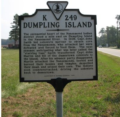
Dumpling Island
Erected 1998 by Department of Historic Resources. (Marker Number K-249.)
Topics and series. This historical marker is listed in these topic lists: Native Americans • Settlements & Settlers. In addition, it is included in the Virginia Department of Historic Resources (DHR) series list. A significant historical year for this entry is 1608.
Location. 36° 49.165′ N, 76° 34.727′ W. Marker is in Suffolk, Virginia. It is in Chuckatuck. Marker is on Goodwin Boulevard (Route 10) 0.4 miles north of Harrell Drive, on the right when traveling north. Touch for map. Marker is in this post office area: Suffolk VA 23434, United States of America. Touch for directions.
Other nearby markers. At least 8 other markers are within 5 miles of this marker, measured as the crow flies. Nansemond Indian Villages (approx. 2.3 miles away); St. John's Church (approx. 2.8 miles away); James Bowser Plantation (approx. 3 miles away); Revolutionary Camp (approx. 3.6 miles away); Civil War Cavalry Skirmish (approx. 3.9 miles away); Siege of Suffolk (approx. 4.2 miles away); James Bowser, Revolutionary Soldier (approx. 4.2 miles away); Sleepy Hole Ferry (approx. 4.3 miles away). Touch for a list and map of all markers in Suffolk.
Credits. This page was last revised on February 1, 2023. It was originally submitted on September 23, 2007, by Laura Troy of Burke, Virginia. This page has been viewed 3,351 times since then and 183 times this year. Photo 1. submitted on September 23, 2007, by Laura Troy of Burke, Virginia. • J. J. Prats was the editor who published this page.
Editor’s want-list for this marker. Wide shot of marker and its surroundings. • Can you help?
