Batavia in Genesee County, New York — The American Northeast (Mid-Atlantic)
War of 1812
Bicentennial Peace Garden
| — | Batavia | — |
Photographed by Steve Stoessel, March 3, 2025
1. War of 1812 Marker
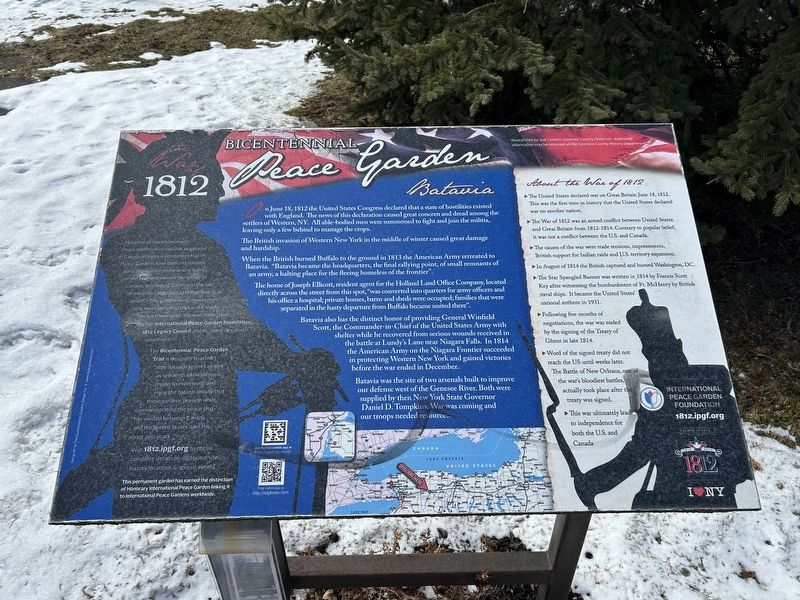
On June 18, 1812 the United States Congress declared that a state of hostilities existed with England. The news of this declaration caused great concern and dread among the settlers of Western, NY. All able-bodied men were summoned to fight and join the militia, leaving only a few behind to manage the crops.
The British invasion of Western New York in the middle of winter caused great damage and hardship.
When the British burned Buffalo to the ground in 1813 the American Army retreated to Batavia. "Batavia became the headquarters, the final rallying point, of small remnants of an army, a halting place for the fleeing homeless of the frontier".
The home of Joseph Ellicott, resident agent for the Holland Land Office Company, located directly across the street from this spot, "was converted into quarters for army officers and his office a hospital; private homes, barns and sheds were occupied; families that were separated in the hasty departure from Buffalo became united there".
Batavia also has the distinct honor of providing General Winfield Scott, the Commander-in-Chief of the United States Army with shelter while
this page online
Batavia was the site of two arsenals built to improve our defense west of the Genesee River. Both were supplied by then New York State Governor Daniel D. Tompkins. War was coming and our troops needed resources.
About the War of 1812
• The United States declared war on Great Britain June 18, 1812. This was the first time in history that the United States declared war on another nation.
• The War of 1812 was an armed conflict between United States and Great Britain from 1812-1814. Contrary to popular belief, it was not a conflict between the U.S. and Canada.
• The causes of the war were trade tensions, impressments, British support for Indian raids and U.S. territory expansion.
• In August of 1814 the British captured and burned Washington, DC.
• The Star Spangled Banner was written in 1814 by Francis Scott Key after witnessing the bombardment of Ft. McHenry by British naval ships.
Photographed by Steve Stoessel, March 3, 2025
2. War of 1812 Marker
• Following five months of negotiations, the war was ended by the signing of the Treaty of Ghent in late 1814.
• Word of the signed treaty did not reach the US until weeks later. The Battle of New Orleans, one of the war's bloodiest battles, actually took place after the treaty was signed.
•This war ultimately lead to independence for both the U.S. and Canada
Modeled on the International Peace Garden concept that originated in Canada in 1990, a permanent trail of Peace Gardens have been established along the historic route where events of the War determined the future of Canada, the United States and the fate of many First Nations and Native American people. The garden route covers over 600 miles including USA and Canada This is a cooperative initiative undertaken by the International Peace Garden Foundation, 1812 Legacy Council and its many devoted volunteers.
The Bicentennial Peace Garden Trail is designed to attract international visitors as well as residents of this historic region to experience and enjoy the natural beauty that these gardens provide while, commemorating the peace that has existed between Canada and the United States over the past 200 years. Visit 1812.ipgf.org to obtain complete details on additional sites, history,locations & special events This permanent garden has earned the distinction of Honorary International Peace Garden linking it to International Peace Gardens worldwide.
Erected by I❤️NY, International Peace Garden Foundation.
Topics. This memorial is listed in these topic lists: Peace • War of 1812. A significant historical date for this entry is June 18, 1812.
Location. 42° 59.948′ N, 78° 11.423′ W. Memorial is in Batavia, New York, in Genesee County. It is on West Main Street (New York State Route 5) near Thomas Avenue, on the left when traveling west. Touch for map. Memorial is at or near this postal address: 113 W Main St, Batavia NY 14020, United States of America. Touch for directions.

Regionally, this memorial is in Upstate New York, specifically in Western New York, in the Finger Lakes, and in the Rochester Metropolitan Area. It is also in the American Northeast and in the Mid-Atlantic. Globally, it is in North America, the Western Hemisphere, the Western World, and the Anglosphere. Historically, it finds itself in what was once the Haudenosaunee (Iroquois) Confederacy, New Netherland, and one of the original Thirteen Colonies.
Other nearby markers. At least 8 other markers are within walking distance of this marker: Paolo Busti Monument (here, next to this marker); Batavia Peace Garden (here, next to this marker); Gabriel DeFabbio (a few steps from this marker); Batavia Peace Garden Artwork & Monuments (a few steps from this marker); Batavia (within shouting distance of this marker); Capt. Charles F. Rand (within shouting distance of this marker); The Grove of Nations / The Millstone (within shouting distance of this marker); a different marker also named Batavia Peace Garden (about 300 feet away, measured in a direct line). Touch for a list and map of all markers in Batavia.
Also see . . . War of 1812 (Wikipedia). (Submitted on March 3, 2025, by Steve Stoessel of Niskayuna, New York.)
Credits. This page was last revised on March 3, 2025. It was originally submitted on March 3, 2025, by Steve Stoessel of Niskayuna, New York. This page has been viewed 229 times since then and 48 times this year. Photos: 1, 2. submitted on March 3, 2025, by Steve Stoessel of Niskayuna, New York.
