Vaux-devant-Damloup near Douaumont-Vaux in Meuse, Alsace, Lorraine, Champagne-Ardenne, France — Western Europe
De sa construction à la bataille de Verdun
1905-1912 : La modernisation des organes de tir, les tourelles cuirassées
Photographed by Steve Stoessel, November 18, 2024
1. De sa construction à la bataille de Verdun Marker

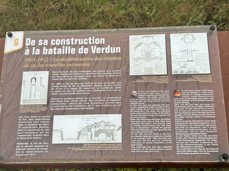
Dans les forts les plus modernisés, des canons sous tourelles d'acier remplacent l'artillerie à découvert. Ces tourelles pivotent sur elles-mêmes et s'abaissent dans leur massif de béton armé lorsqu'elles ne tirent pas (éclipse).
En 1904, le fort de Vaux est doté de ce type de tourelle sous calotte d'acier de 30 cm d'épaisseur, équipée de deux canons de 75 mm à tir rapide (22 coups/mn). La tourelle est placée au centre du fort. 18 artilleurs sont nécessaires à sa mise en action et au service des deux canons.
Disposé à quelques mètres de la tourelle, un observatoire d'artillerie sous cloche d'acier fixe complète le dispositif. L'observateur indique par tube acoustique (comme dans un sous-marin) les indications de tir aux artilleurs qui ont des capacités d'observation très limitées.
Aux ailes droite et gauche du fort, deux observatoires identiques sont insérés dans la carapace de béton. Ils caractérisent parfaitement la pertinence du site pour renseigner sur les mouvements ennemis dans la plaine de la Woëvre.
Modernisé, le fort de Vaux est un élément essentiel du dispositif défensif de Verdun lors du déclenchement
this page online
In 1904, Fort Vaux was equipped with such a turret protected by a steel cap 30 cm thick, which housed two 75 mm rapid-firing guns (22 shots/min.). The turret was positioned at the centre of the fort. A crew of 18 artillery men was required to bring it into service and man the two guns.
Sited a few metres from the turret, an artillery observation post under a fixed steel dome completed the system. The observer used an acoustic communication tube like those seen in submarines to provide the gunners with firing information as their vision from the turret was strictly limited.
On the right and left flanks of the fort, two identical observation posts were inserted in the concrete shell. They illustrate how important the site was for providing information on enemy movements on the Woëvre plain.
Thus modernised, Fort Vaux was an essential component of the Verdun defence system when
Photographed by Steve Stoessel, November 18, 2024
2. De sa construction à la bataille de Verdun Marker
1904 wird das Fort Vaux mit dieser Art Geschützturm mit 30 cm dicken Stahlhaube und zwei 75-mm-Schnellfeuerwaffen (22 Schuss pro Minute) ausgerüstet. Der Geschützturm wird in der Mitte des Forts eingebaut. Für den Einsatz und den Dienst an den beiden Kanonen werden 18 Artilleristen benötigt.
Ergänzt wurde der Geschützturm durch einen feststehenden Beobachtungsposten unter Stahlkuppel. Der Beobachtungsposten gab über ein Sprachrohr (wie in einem U-Boot) Schießanweisungen an die Artilleristen, die nur sehr begrenzte Beobachtungsmöglichkeiten hatten.
An den Flanken rechts und links des Forts werden zwei identische. Beobachtungsposten in den Betonpanzer eingelassen. Sie zeigen, wie gut der Standort ausgestattet ist, um die Feindbewegungen in der Ebene des Waberlandes zu erkennen.
Das modernisierte Fort Vaux ist bei Ausbruch des Ersten Weltkrieges 1914 ein Kernelement
Photographed by Steve Stoessel, November 18, 2024
3. De sa construction à la bataille de Verdun Marker
Topics. This historical marker is listed in these topic lists: Forts and Castles • War, World I. A significant historical year for this entry is 1904.
Location. 49° 12.024′ N, 5° 28.183′ E. Marker is near Douaumont-Vaux, Grand Est (Alsace, Lorraine, Champagne-Ardenne), in Meuse. It is in Vaux-devant-Damloup. It can be reached from Grand Est Route 913A 3.2 kilometers north of Route 913. The fort is at the end of D913a. Touch for map. Marker is at or near this postal address: D913a, Douaumont-Vaux, Grand Est 55400, France. Touch for directions.

Regionally, it is in the North Atlantic Region, Europe, the European Union, Atlantic Europe, the Schengen Area, Western Europe, a coastal Mediterranean country, and the Western World. Historically, it finds itself in what was once a French colony, the Roman Empire, and specifically the Holy Roman Empire.
Other nearby markers. At least 8 other markers are within walking distance of this marker: Dans la bataille de Verdun (here, next to this marker); a different marker also named De sa construction à la bataille de Verdun (here, next to this marker); a different marker also named De sa construction à la bataille de Verdun (here, next to this marker); Dans la Bataille de Verdun (a few steps from this marker); a different marker also named Dans la Bataille de Verdun (a few steps from this marker); a different marker also named De sa construction à la bataille de Verdun (a few steps from this marker); a different marker also named Dans la bataille de Verdun (a few steps from this marker); a different marker also named De sa construction à la bataille de Verdun (a few steps from this marker). Touch for a list and map of all markers in Douaumont-Vaux.
Credits. This page was last revised on March 5, 2025. It was originally submitted on March 5, 2025, by Steve Stoessel of Niskayuna, New York. This page has been viewed 118 times since then and 22 times this year. Photos: 1, 2, 3. submitted on March 5, 2025, by Steve Stoessel of Niskayuna, New York.
