Timpson in Shelby County, Texas — The American South (West South Central)
Timpson
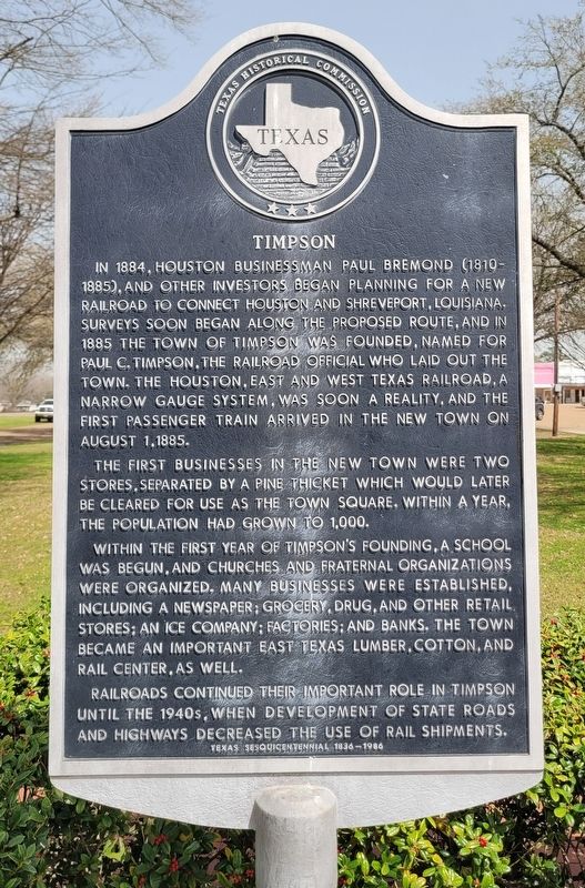
Photographed by James Hulse, March 15, 2025
1. Timpson Marker
The first businesses in the new town were two stores, separated by a pine thicket which would later be cleared for use as the town square, within a year, the population had grown to 1,000.
Within the first year of Timpson's founding, a school was begun, and churches and fraternal organizations were organized. Many businesses were established, including a newspaper; grocery, drug, and other retail stores; an ice company; factories; and banks. The town became an important East Texas lumber, cotton, and rail center, as well.
Railroads continued their important role in Timpson until the 1940s, when development of state roads and highways decreased the use of rail shipments.
Erected 1986 by Texas Historical Commission. (Marker Number 7700.)
Topics. This historical marker is listed in these topic lists: Industry & Commerce • Railroads & Streetcars • Settlements & Settlers. A significant historical date for this entry is August 1, 1885.
Location. 31° 54.314′ N, 94° 23.865′ W. Marker is in Timpson, Texas, in Shelby County. It is at the intersection of Jacob Street (State Road 87) and Park Plaza St, on the right when traveling north on Jacob Street. The marker is located in the western section of the Timpson Downtown Park Plaza. Touch for map. Marker is at or near this postal address: 397 Jacob St,
this page online

Regionally, this marker is in the American South, specifically in the Deep South, and in the Piney Woods. Globally, it is in North America, a Gulf of Mexico state, the Western Hemisphere, the Western World, and the Anglosphere. Historically, it finds itself in what was once New Spain, the Republic of Texas, one of the Confederate States of America, and the Antebellum South.
Other nearby markers. At least 8 other markers are within 6 miles of this marker, measured as the crow flies: In Memory of Our Boys (within shouting distance of this marker); a different marker also named In Memory of Our Boys (within shouting distance of this marker); First Baptist Church of Timpson (approx. 0.2 miles away); Buena Vista Cemetery (approx. 3.4 miles away); George Washington Green (approx. 4.3 miles away); Tennessee Presbyterian Church (approx. 5.9 miles away); Tennessee Community Cemetery (approx. 5.9 miles away); Tennessee Methodist Church (approx. 5.9 miles away). Touch for a list and map of all markers in Timpson.

Photographed by James Hulse, March 15, 2025
2. Timpson Marker
The marker is located in the Timpson Downtown Park Plaza.
Credits. This page was last revised on March 19, 2025. It was originally submitted on March 18, 2025, by James Hulse of Medina, Texas. This page has been viewed 262 times since then and 51 times this year. Photos: 1, 2. submitted on March 19, 2025, by James Hulse of Medina, Texas.
