Tombstone in Cochise County, Arizona — The American Mountains (Southwest)
"You're a Lucky Cuss!"
1878

Photographed by Ian Lefkowitz, September 1, 2022
1. "You're a Lucky Cuss!" Marker
Unfortunately, the vein soon petered out. After weeks of searching, Ed discovered a second richer vein. You're a “lucky cuss” remarked his brother Al Schieffelin, and so the Lucky Cuss mine was born. The good news quickly spread, and an army of prospectors soon arrived. The town of Tombstone grew to become one of the greatest silver camps in the West (see map). Nearly 1,000 tons of silver worth well over one billion in today's dollars were mined - more silver than in any other mining camp in Arizona. And the Lucky Cuss mine became one of Tombstone's richest, with workings a mile long and 650 feet deep (see photo).
Everyone wanted to strike it rich, including Wyatt Earp. Pictured is a diagram Wyatt helped draw locating his mine called the Congress on the edge of Tombstone. The map even shows the water line on Fremont Street over which Morgan
this page online
Topics. This historical marker is listed in these topic lists: Industry & Commerce • Settlements & Settlers. A significant historical year for this entry is 1878.
Location. 31° 42.784′ N, 110° 4.05′ W. Marker is in Tombstone, Arizona, in Cochise County. It is on East Allen Street. Touch for map. Marker is at or near this postal address: 328 E Allen Street, Tombstone AZ 85638, United States of America. Touch for directions.

Regionally, this marker is in the Sky Islands and in Southeastern Arizona. It is also in the American Borderlands and in the Southwest. Globally, it is in North America, the Western Hemisphere, the Western World, and the Anglosphere. Historically, it finds itself in what was once New Spain and also the Gadsden Purchase.
Other nearby markers. At least 8 other markers are within walking distance of this marker: Can Can Restaurant (within shouting distance of this marker); Cochise County Bank (within shouting distance of this marker); Edward L. Schieffelin (within shouting distance of this marker); Brown's Hotel and Hafford's Saloon
Photographed by Ian Lefkowitz, September 1, 2022
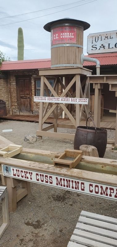
2. Lucky Cuss Mine
A display of the Lucky Cuss Mine is found at the O.K. Corral site. A re-enactment of the founding of Tombstone is found next door at Tombstone's Historama.
Credits. This page was last revised on June 28, 2025. It was originally submitted on March 30, 2025, by Ian Lefkowitz of New York, New York. This page has been viewed 340 times since then and 90 times this year. Photos: 1, 2. submitted on March 30, 2025, by Ian Lefkowitz of New York, New York. • Andrew Ruppenstein was the editor who published this page.
