Cinnaminson in Burlington County, New Jersey — The American Northeast (Mid-Atlantic)
Signal Systems of the Pennsylvania Railroad
Photographed by Devry Becker Jones (CC0), April 3, 2025
1. Signal Systems of the Pennsylvania Railroad Marker
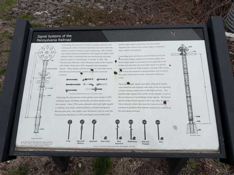
Controlling the movement of trains, avoiding collisions, and ensuring the safety of railroad operations has always been the primary mission of railroad signal engineering. The Camden and Amboy Railroad contributed to the improved safety of the railroad when it introduced the first mechanically activated control system or "interlocking" in Trenton in 1870. The Pennsylvania Railroad, which obtained control of the Camden and Amboy Railroad in 1871, originally used semaphore signals. These signals used the position of a moveable arm to indicate stop (horizontal), caution (diagonal) or proceed (vertical).
Following the introduction of the electric track circuit in 1872, railroad began installing electrically activated signals across the country. After 1910, some railroads used color-light signals to indicate stop (red), caution (yellow), and proceed (green). Because the early color lights were not always easy to read, the Pennsylvania Railroad, in 1915, developed and installed the position-light signal system that used horizontal, diagonal, and vertical rows of three lights to represent stop, caution, and proceed.
Controlling
this page online
The position light signals and other antiquated signals were removed and replaced with state of the art signaling systems during construction of this light-rail line. The position-light signal at the center of this display is one of the two Rancocas Creek Bridge home signals. NJ Transit donated both distant signals to the Cape May Seashore Lines railroad, where they may be viewed as they continue to perform their historic function of controlling the movement of trains.
Erected by New Jersey Transit Corporation.
Topics and series. This historical marker is listed in these topic lists: Bridges & Viaducts • Communications • Railroads & Streetcars. In addition, it is included in the Pennsylvania Railroad (PRR) series list. A significant historical year for this entry is 1870.
Location. 40° 0.993′ N,
Photographed by Devry Becker Jones (CC0), April 3, 2025
2. Signal Systems of the Pennsylvania Railroad Marker

Regionally, this marker is in South Jersey and in Greater Philadelphia. It is also in the American Northeast, in the Mid-Atlantic, and on the Eastern Seaboard. Globally, it is in the North Atlantic Region, North America, the Western Hemisphere, the Western World, and the Anglosphere. Historically, it finds itself in what was once New Netherland and also one of the original Thirteen Colonies.
Other nearby markers. At least 8 other markers are within walking distance of this marker: Look Listen and Live (here, next to this marker); Riverton Memorial Park (approx. 0.7 miles away); In Memory of Lives lost by Riverton Gold Star Servicemen in World War 1 (approx. 0.8 miles away); Riverton Public School (approx. 0.8 miles away); Veterans Memorial (approx. 0.8 miles away); Patrolman Thomas C. Whitelock (approx. 0.8 miles away); Riverton (approx. 0.8 miles away); Christ Episcopal Church (approx. 0.9 miles away).
Credits. This page was last revised on April 6, 2025. It was originally submitted on April 6, 2025, by Devry Becker Jones of Washington, District of Columbia. This page has been viewed 321 times since then and 110 times this year. Photos: 1, 2. submitted on April 6, 2025, by Devry Becker Jones of Washington, District of Columbia.
