Port Richmond on Staten Island in Richmond County, New York — The American Northeast (Mid-Atlantic)
Workers and Laborers
Anonymous Laborers Build the Bridge from the Ground Up
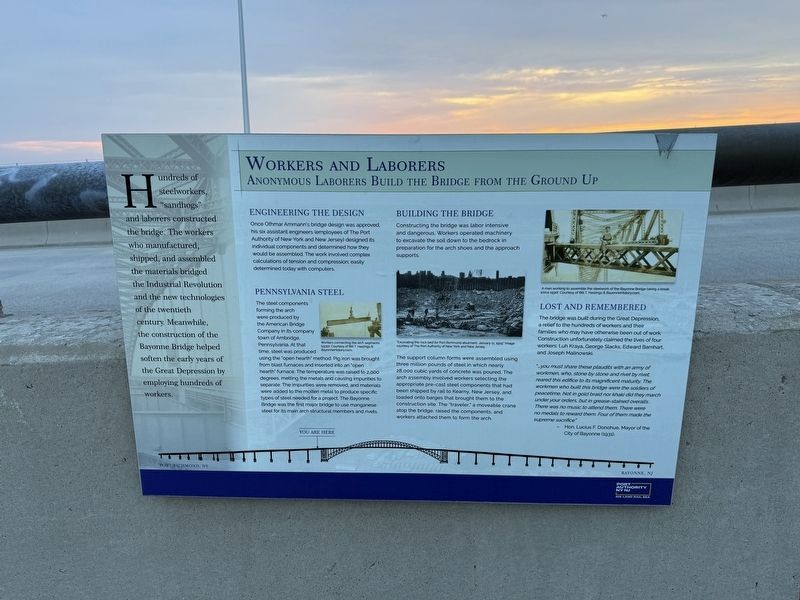
Hundreds of steelworkers, "sandhogs" and laborers constructed the bridge. The workers who manufactured, shipped, and assembled the materials bridge the Industrial Revolution and the new technologies of the twentieth century. Meanwhile, the construction of the Bayonne Bridge helped soften the early of the Great Depression bye employing hundreds of workers.
Engineering the Design
Once Othmar Ammann's bridge design was approved, his six assistant engineers (employees of The Port Authority of New York and New Jersey) designed its individual components and determined how they would be assembled. The work involved complex calculations of tension and compression; easily determined today with computers.
Pennsylvania Steel
The steel components forming the Arch were produced by the American Bridge Company in its company town of Ambridge, Pennsylvania At that time, steel was produced using the "open hearth" method. Pig iron was brought from blast furnaces and inserted into an "open hearth" furnace. The temperature was raised to 2,000 degrees, melting the metals and causing impurities to separate. The impurities were removed,
this page online
Building the Bridge
Constructing the bridge was labor intensive and dangerous. Workers operated machinery to excavate the soil down to the bedrock in preparation for the Arch shoes and the approach supports.
The support column forms were assembled using three million pounds of steel in which nearly 28,000 cubic yards of concrete was poured. The arch assembly involved workers selecting the appropriate pre-cast steel components that had been shipped by rail to Kearney, New Jersey, and loaded onto barges that brought them to the construction site. The "traveler," a moveable Crane atop the bridge, raised the components, and workers attached them to form the arch.
Lost and Remembered
The bridge was built during the Great Depression, a relief to the hundreds of workers and their families who may have otherwise been out of work. Construction unfortunately claimed the lives of four workers: Luh Kraya, George Slacks,

"…you must share these plaudits with an army of workmen, who, stone by stone and rivet by rivet, reared this edifice to its magnificent maturity. The workmen who built this bridge were the soldiers of peacetime. Not in gold braid nor khaki did they march under your orders, but in grease-stained overalls. There was no music to attend them. There were no medals to reward them. Four of them made the supreme sacrifice."
- Hon. Lucius F. Donohue, Mayor of the City of Bayonne (1931).
Erected by Port Authority of New York and New Jersey.
Topics. This historical marker is listed in these topic lists: Bridges & Viaducts • Industry & Commerce.
Location. 40° 38.36′ N, 74° 8.599′ W. Marker is on Staten Island, New York, in Richmond County. It is in Port Richmond. It is on Bayonne Bridge (Route 440) north of Trantor Place when traveling north. Touch for map. Marker is at or near this postal address: 15 Bayonne Brg, Staten Island NY 10302, United States of America. Touch for directions.

Regionally, this marker is in New York City. It is also in the American Northeast, in the Mid-Atlantic, and on the Eastern Seaboard. Globally, it is in the North Atlantic Region, North America, the Western Hemisphere, the Western World, and the Anglosphere. Historically, it finds itself in what was once New Netherland and also one of the original Thirteen Colonies.
Other nearby markers. At least 8 other markers are within walking distance of this marker: Boats and Boxes (about 400 feet away, measured in a direct line); Designers and Engineers (about 800 feet away); Raising the Roadway (approx. 0.2 miles away); Recreation and Leisure (approx. 0.3 miles away); Neighborhoods & People (approx. 0.4 miles away); George Washington (approx. 0.4 miles away); Port Richmond (approx. 0.4 miles away); a different marker also named Faber Park and Pool (approx. 0.4 miles away). Touch for a list and map of all markers in Staten Island.
Another marker is no longer nearby. Faber Park and Pool (was approx. 0.4 miles away but has been replaced with another marker now near it).
Credits. This page was last revised on June 23, 2025. It was originally submitted on April 26, 2025, by Devry Becker Jones of Washington, District of Columbia. This page has been viewed 134 times since then and 18 times this year. Photos: 1, 2. submitted on April 26, 2025, by Devry Becker Jones of Washington, District of Columbia.
