Ashford in Kent, England, United Kingdom — Northwestern Europe (the British Isles)
The Borough Arms
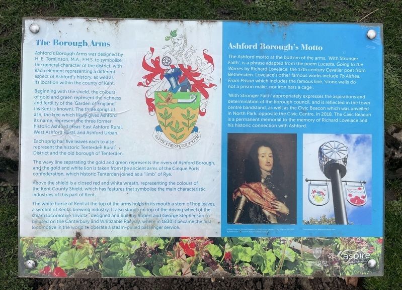
Photographed by Ray Gurganus, March 25, 2025
1. The Borough Arms Marker
Ashford's Borough Arms was designed by H. E. Tomlinson, M.A., F.H.S. to symbolise the general character of the district, with each element representing a different aspect of Ashford's history, as well as its location within the county of Kent.
Beginning with the shield, the colours of gold and green represent the richness and fertility of the 'Garden of England (as Kent is known). The three sprigs of ash, the tree which likely gives Ashford its name, represent the three former historic Ashford areas: East Ashford Rural, West Ashford Rural, and Ashford Urban.
Each sprig has five leaves each to also represent the historic Tenterden Rural, District and the old borough of Tenterden.
The wavy line separating the gold and green represents the rivers of Ashford Borough, and the gold and white lion is taken from the ancient arms of the Cinque Ports confederation, which historic Tenterden joined as a "limb" of Rye.
Above the shield is a closed red and white wreath, representing the colours of the Kent County Shield, which has features that symbolise the main characteristic industries of this part of Kent.
The white
this page online
Ashford Borough's Motto
The Ashford motto at the bottom of the arms, With Stronger Faith', is a phrase adapted from the poem Lucasta. Going to the Warres by Richard Lovelace, the 17th century Cavalier poet from Bethersden. Lovelace's other famous works include To Althea. From Prison which includes the famous line, 'stone walls do not a prison make, nor iron bars a cage.
"With Stronger Faith" appropriately expresses the aspirations and determination of the borough council, and is reflected in the town centre bandstand, as well as the Civic Beacon which was unveiled in North Park, opposite the Civic Centre, in 2018. The Civic Beacon is a permanent memorial to the memory of Richard Lovelace and his historic connection with Ashford.
Erected by Ashford

Photographed by Ray Gurganus, March 25, 2025
2. The Borough Arms
Topics. This historical marker is listed in this topic list: Patriots & Patriotism. A significant historical year for this entry is 1830.
Location. 51° 8.786′ N, 0° 52.431′ E. Marker is in Ashford, England, in Kent. It can be reached from Church Road north of Queen Street, on the right when traveling north. The marker stands in Ashford Memorial Gardens. Touch for map. Marker is in this post office area: Ashford, England TN23 1RD, United Kingdom. Touch for directions.

Regionally, this marker is in the Greater South East. Globally, it is on the Atlantic Ocean, in the North Atlantic Region, in Europe, in Atlantic Europe, on one of the British Isles, in the Western World, and in the Anglosphere. Historically, it finds itself in what was once the Roman Empire.
Other nearby markers. At least 8 other markers are within walking distance of this marker: Anne Frank's Tree (within shouting distance of this marker); HMS Albacore and 'Warship Week' (within shouting distance of this marker); TS Churchill, Ashford Sea & Royal Marine Cadets (within shouting distance of this marker); Grammar School (approx. 0.3 kilometers away); The Oldest Parts of this Building... (approx. 0.3 kilometers away); British Mark IV Female Tank, No 245 (approx. half a kilometer away); Bowen Field (approx. 0.6 kilometers away); Mystery of the Stags (approx. 0.6 kilometers away). Touch for a list and map of all markers in Ashford.
Credits. This page was last revised on May 19, 2025. It was originally submitted on April 26, 2025, by Ray Gurganus of Washington, District of Columbia. This page has been viewed 154 times since then and 35 times this year. Photos: 1, 2. submitted on April 26, 2025, by Ray Gurganus of Washington, District of Columbia. • Devry Becker Jones was the editor who published this page.
