
Fort Snelling in Hennepin County, Minnesota — The American Midwest (Upper Plains)
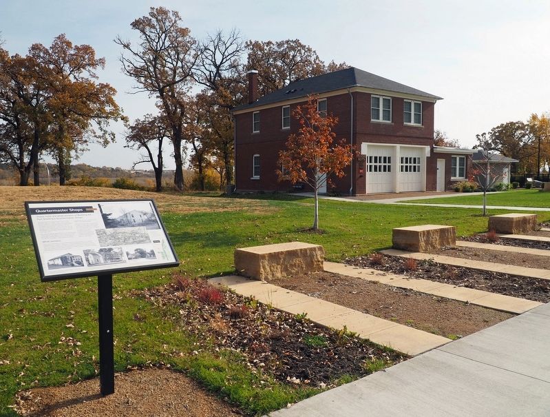
Quartermaster Shops
Est. 1879-1880

Photographed by McGhiever, October 21, 2024
1. Quartermaster Shops Marker
These ruins are what remains of Building 63, Fort Snelling's Quartermaster Shops.
The Quartermaster Shops were constructed between 1879 and 1880. It was one of dozens of new additions to the fort when the Department of Dakota Headquarters moved to the fort. The fort's rapid growth meant new work for the Quartermaster Department who were in charge of making sure buildings and equipment were in working order.
Like other buildings at the fort, this one has played many roles. In the 1880s, it was used as the post exchange, a small store for those who lived at the fort. In the 1930s, it was turned into eight apartments for non-commissioned officers and their families.
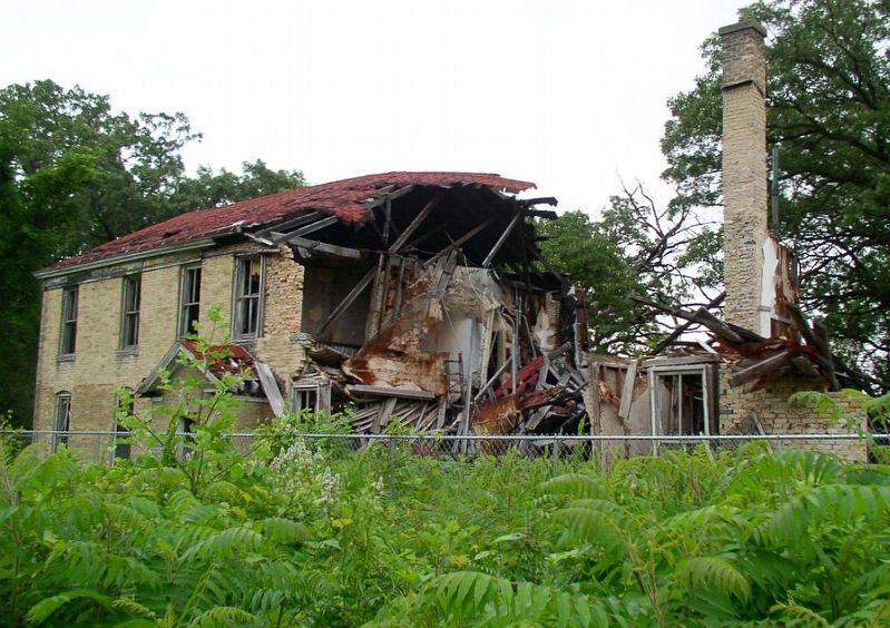
After the fort was decommissioned in 1946, Building 63 was left vacant. Throughout the 1990s and 2000s, the roof rotted and water damaged the structure. A heavy snowfall collapsed a section of the building in 2008. Gradually more walls fell, leaving behind what you see today.
What remains
The Upper Post used to have many other buildings that are no longer visible from the surface. Evidence of these structures still exists below your feet. Some
this page online
Perspective of west (Front) and south side elevations, looking northeast, Jet Lowe, Photographer, Library of Congress, Prints & Photographs Division, HABS No. MN-88-0-1
Building 63, Fort Snelling's Quartermaster Ships is highlighted. Map of Fort Snelling, 1939, Work Projects Administration
Radio Station, 1938 Quartermasters Reports, Fort Snelling, Minnesota Historical Society
NCO Quarters - Building 72, 1938 Quartermasters Reports, Fort Snelling, Minnesota Historical Society
Service Club, 1938 Quartermasters Reports, Fort Snelling, Minnesota Historical Society
Topics. This historical marker is listed in this topic list: Forts and Castles. A significant historical year for this entry is 1879.
Location. 44° 53.232′ N, 93° 11.35′ W. Marker is in Fort Snelling, Minnesota, in Hennepin County. It is at the intersection of Sibley Avenue and Colville Avenue, on the right when traveling east on Sibley Avenue. Touch for map. Marker is at or near this postal address:
Photographed by McGhiever, October 21, 2024
2. Quartermaster Shops Marker northwest of 6375 Sibley Avenue

Regionally, this marker is in the Twin Cities Metropolitan Area. It is also in the American Midwest, in the Corn Belt, and in the Great River Road Region. Globally, it is in North America, the Western Hemisphere, the Western World, and the Anglosphere. Historically, it finds itself in what was once Rupert’s Land, the territory of the Mississippian Culture, and the Louisiana Purchase.
Other nearby markers. At least 8 other markers are within walking distance of this marker: Getting Around at the Fort (within shouting distance of this marker); Military Intelligence Service Language School (about 300 feet away, measured in a direct line); The Upper Post at Fort Snelling (about 300 feet away); Women at Work (about 400 feet away); Medicine at the Fort (about 700 feet away); Military Units of Fort Snelling (about 700 feet away); Fun at the Fort (about 700 feet away); Military Training at Fort Snelling (approx. 0.2 miles away). Touch for a list and map of all markers in Fort Snelling.
Photographed by McGhiever, July 4, 2010
3. The partially collapsed Quartermaster Shops in 2010
Credits. This page was last revised on May 4, 2025. It was originally submitted on April 27, 2025, by McGhiever of Minneapolis, Minnesota. This page has been viewed 100 times since then and 12 times this year. Photos: 1, 2. submitted on April 27, 2025, by McGhiever of Minneapolis, Minnesota. 3. submitted on May 4, 2025, by McGhiever of Minneapolis, Minnesota.
