Charing in Kent, England, United Kingdom — Northwestern Europe (the British Isles)
Historic Charing
Photographed by Ray Gurganus, March 27, 2025
1. Historic Charing Marker
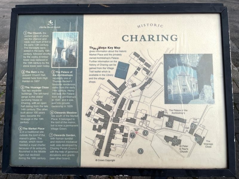
The village Key Map gives information about the historic Market Place and the privately owned Archbishop's Palace. Further information on the history of Charing can be gained from the Village Trail leaflet which is available in the Library and the village shops.
(1) The Church, the earliest parts of which are the chancel and nave, was built of flint in the early 13th century. The transepts were added in the early 14th century, followed shortly by the vestry. A timber tower was replaced in the 15th century by the stone tower seen today.
(2) The Barn is the present Church Hall, moved here from High Halden in 1957.
(3) The Vicarage Close has two separate buildings. The left-hand range is the oldest Surviving house in Charing, with an open hall dating from the late 14th century. The other. built about 100 years later, became the Vicarage in the 19th century.
(4) The Market Place is in a traditional site outside the lord of the manor's gates. The market, which never needed a royal charter because of its antiquity, flourished in the Middle Ages but declined during the 16th century.
(5) The Palace of the Archbishops,
this page online
(6) Clewards Meadow lies south of the Market Place. It belonged to the lord of the manor, but is now a permanent Village Green.
(7) Clewards Garden, with human sundial and restored mediaeval wall, was developed by Charing Parish Council with the help of generous donations and grants (see other board).
Erected by Charing Parish Council.
Topics. This historical marker is listed in this topic list: Notable Buildings.
Location. 51° 12.63′ N, 0° 47.731′ E. Marker is in Charing, England, in Kent. It is on Market Place. Touch for map. Marker is at or near this postal address: 5 Market Pl, Charing, England TN27 0LP, United Kingdom. Touch for directions.

Regionally, this marker is in the Greater South East. Globally, it is on the Atlantic Ocean, in the North Atlantic Region, in Europe, in Atlantic Europe, on one of the British Isles, in the Western World, and in the Anglosphere.

Photographed by Ray Gurganus
2. Charing Parish Church
Other nearby markers. At least 8 other markers are within 10 kilometers of this marker, measured as the crow flies: A different marker also named Historic Charing (here, next to this marker); Corporal Frederick George Coppins VC (a few steps from this marker); In the Parish of Calehill with Westwell (within shouting distance of this marker); A medieval building (about 240 meters away, measured in a direct line); Ronald N. Stuart Victoria Cross (approx. 0.3 kilometers away); To mark the Centenary of the WW1 Armistice (approx. 0.3 kilometers away); Simone Weil (approx. 8.3 kilometers away); British Mark IV Female Tank, No 245 (approx. 8.5 kilometers away). Touch for a list and map of all markers in Charing.
Credits. This page was last revised on May 2, 2025. It was originally submitted on May 1, 2025, by Ray Gurganus of Washington, District of Columbia. This page has been viewed 104 times since then and 15 times this year. Photos: 1, 2. submitted on May 1, 2025, by Ray Gurganus of Washington, District of Columbia. • Andrew Ruppenstein was the editor who published this page.
