Bruce Mines in Algoma District, Ontario — Central Canada (North America)
Bruce Mines Museum
Brimming With Stories of a Mining Town
⎯⎯⎯
Musée de Bruce Mines
Un condensé d'histoire d'une localité minière
Photographed by Cosmos Mariner, June 9, 2024
1. Bruce Mines Museum / Musée de Bruce Mines Marker

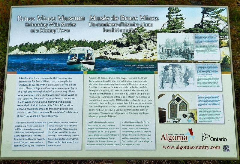
This historic museum building was erected as a Presbyterian church in 1894 but was abandoned in 1917 when the Presbyterian and Methodist churches joined to form the United Church. Over the years it has also been used as a post office, library and school until 1961 when it became the Bruce Mines Museum. Housed within the walls of the "Church on the Rock" are over 4,000 historical objects. Come and enjoy the rich history that started when Cornish Miners settled the town of Bruce Mines in 1846.
Copper mining began in 1846
this page online
The museum is really about people. This photo, taken around 1900, shows the faces of men that endured the hardship of working in the confined spaces of a hard rock mine. Each object in the museum has a story to tell about people in the area of Bruce Mines.
There are 3 exhibit rooms full of interesting objects. Look for the ornate globe lamps from the early days of electricity. Look for the many inventions that made house work easier. Look for objects from the dentist's office, the creamery, the farms, the logging and, of course, the mines.

Photographed by Cosmos Mariner, June 9, 2024
2. Bruce Mines Museum / Musée de Bruce Mines Marker
Looking south; Bruce Mines Museum is in the background.
L'édifice historique du musée a été construit en 1894 pour servir d'église presbytérienne, mais il a été abandonné en 1917 alors que les églises presbytérienne et méthodiste se sont regroupées pour former l'Église unie. Au cours des ans, ce bâtiment a abrité le bureau de poste, la bibliothèque et l'école. En 1961, il est devenu le musée de Bruce Mines. Les murs de cette église contiennent plus de 4000 artefacts. Venez admirer la riche histoire qui a débuté quand des mineurs de Cornouailles ont fondé le village de Bruce Mines en 1846.
La mine de cuivré a ouvert en 1846 mais a fermé 30 ans plus tard en raison d'inondations et déboulements. En 1915, elle est rouverte pour refermer en 1921. On peut visiter les puits de mine, qui se trouvent tout près.
Le musée est dédié aux gens. Prise vers 1900, cette photo immortalise les visages des hommes qui ont travaillé dans les conditions difficiles de ces mines de roche dure. Chaque objet du musée raconte une histoire sur ces gens de la région de Bruce Mines.
Le musée comprend trois salles d'exposition remplies d'objets fort intéressants : des lampes à globe décorées qui témoignent des premiers temps de l'électricité, les nombreuses inventions qui sont venues faciliter le travail domestique, des articles provenant d'un cabinet de dentiste, d'une crèmerie, de fermes, ainsi que des activités forestières et, bien entendu, minières.
Topics. This historical marker is listed in these topic lists: Industry & Commerce • Religion & Religious Structures • Settlements & Settlers. A significant historical year for this entry is 1894.
Location. 46° 18.03′ N, 83° 47.273′ W. Marker is in Bruce Mines, Ontario, in Algoma District. It is at the intersection of Trans-Canada Highway (Provincial Highway 17) and Robinson Drive, on the right when traveling east on Trans-Canada Highway. The marker is located directly in front of the Bruce Mines Museum. Touch for map. Marker is at or near this postal address: 9227 Trans-Canada Hwy, Bruce Mines ON P0R 1C0, Canada. Touch for directions.

Regionally, this marker is in the Sault Ste. Marie and Algoma Area and in Northern Ontario. It is also in Central Canada. Globally, it is in North America, in the Great North Woods, on the Great Lakes, on Lake Superior’s North Shore, in the Western Hemisphere, in the Western World, and in the Anglosphere. Historically, it finds itself in what was once a British colony, the Viceroyalty of New France, the Haudenosaunee (Iroquois) Confederacy, and Rupert’s Land.
Other nearby markers. At least 4 other markers are within 23 kilometers of this marker, measured as the crow flies: The Bruce Mines (a few steps from this marker); "Ripple Rock" (approx. 13.5 kilometers away); Carterton (approx. 17.2 kilometers away); Tenby Bay (approx. 22.2 kilometers away).
Also see . . . Bruce Mines Museum.
Excerpt : The building itself has a fascinating history. Built in 1894 as a Presbyterian Church, the "Church on the Rock" was used for services until 1917 when the congregation outgrew the church and united with the Methodist congregation, whose church could accommodate both groups.(Submitted on May 4, 2025, by Cosmos Mariner of Cape Canaveral, Florida.)In the same year, a fire swept through the town and the local postmaster, whose building had been destroyed, moved the post office into the vacant church building. The building was used as a scout and church hall for many years until 1945 when another fire destroyed the Bruce Mines Public School.
The building housed grades 9 - 12 for two years until grades 11 and 12 were moved to the old jail building and finally in December of 1948 the school moved into a new building. The building stood empty until the Town of Bruce Mines purchased it in 1950 when it was used as a public library and as a storage house for local artefacts. The museum officially opened in 1961 and in 1973 the library moved to the Bruce Mines Central School.
Credits. This page was last revised on May 4, 2025. It was originally submitted on May 3, 2025, by Cosmos Mariner of Cape Canaveral, Florida. This page has been viewed 324 times since then and 88 times this year. Photos: 1, 2. submitted on May 4, 2025, by Cosmos Mariner of Cape Canaveral, Florida.
