Walnut Grove in Sacramento County, California — The American West (Pacific Coastal)
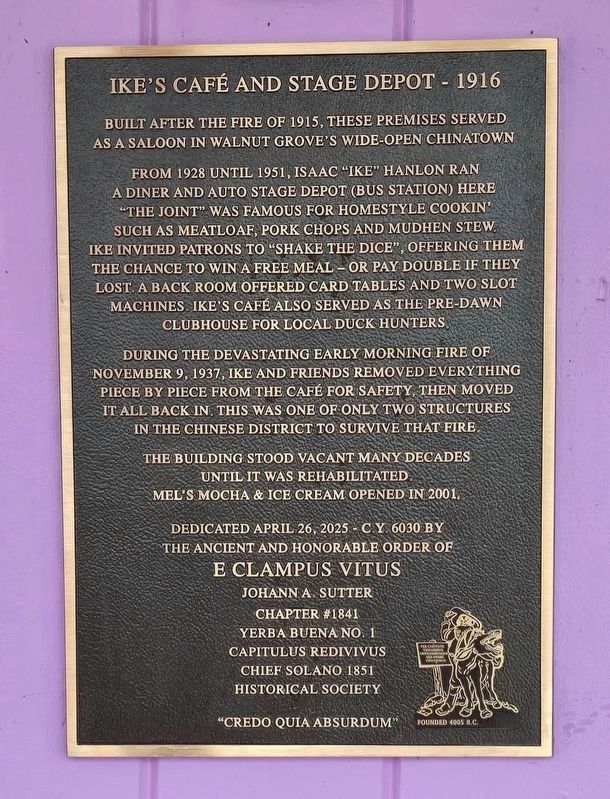
Ike's Cafe and Stage Depot - 1916
| — | "Credo quia absurdum" | — |
Photographed by Yerba Buena Chapter No 1 E Clampus Vitus
1. Ike's Cafe and Stage Depot - 1916 Marker
Built after the fire of 1915, these premises served as a saloon in Walnut Grove's wide-open Chinatown
From 1928 until 1951, Isaac "Ike" Hanlon ran a diner and auto stage depot (bus station) here "the joint" was famous for homestyle cookin' such as meatloaf, pork chops and mudhen stew. Ike invited patrons to "shake the dice", offering them the chance to win a free meal or pay double if they lost. A back room offered card tables and two slot machines Ike's Café also served as the pre-dawn clubhouse for local duck hunters.
During the devastating early morning fire of November 9, 1937, Ike and friends removed everything piece by piece from the café for safety, then moved it all back in. This was one of only two structures in the Chinese district to survive that fire.
The building stood vacant many decades until it was rehabilitated. Mel's Mocha & Ice Cream opened in 2001.
Erected by E Clampus Vitus, Johann A. Sutter Chapter No. 1841, Yerba Buena Chapter No.1 Capitulus Redivivus, Chief Solano 1851 Historical Society.
Topics. This historical marker is listed in these topic lists: Asian Americans •
this page online
Location. 38° 14.578′ N, 121° 30.787′ W. Marker is in Walnut Grove, California, in Sacramento County. It is at the intersection of River Road (County Road E13) and C Street, on the right when traveling north on River Road. Touch for map. Marker is at or near this postal address: 14131 River Rd, Walnut Grove CA 95690, United States of America. Touch for directions.

Regionally, this marker is in the Sacramento Valley and specifically in the Central Valley. It is also on the American Pacific Coast. Globally, it is in North America, on the Ring of Fire, on the Pacific Rim, in the Western Hemisphere, in the Western World, and in the Anglosphere. Historically, it finds itself in what was once New Spain and also Mexico’s Alta California.
Other nearby markers. At least 8 other markers are within walking distance of this marker: Boon-Dox Botel (a few steps from this marker); Sacramento River Exploration (about 400 feet away, measured in a direct line); Delta Transmission Towers/Delta Cross Channel Gates (approx. 0.4 miles away); Charles “Chuck” Tison (approx. 0.4 miles away); Walnut Grove, Est. 1850/Locke, Est. 1915 (approx. 0.4 miles away); Locke (approx. half a mile away); Locke, California (approx. half a mile away); Al the Wop's / Bing Lee's Noodle House (approx. 0.6 miles away). Touch for a list and map of all markers in Walnut Grove.
Credits. This page was last revised on May 15, 2025. It was originally submitted on May 6, 2025, by Frank Gunshow Sanchez of Hollister, California. This page has been viewed 135 times since then and 28 times this year. Photo 1. submitted on May 6, 2025, by Frank Gunshow Sanchez of Hollister, California. • Devry Becker Jones was the editor who published this page.
