Troy Hill in Pittsburgh in Allegheny County, Pennsylvania — The American Northeast (Mid-Atlantic)
Historic Site
Photographed by Bradley Owen, April 28, 2025
1. Historic Site Marker
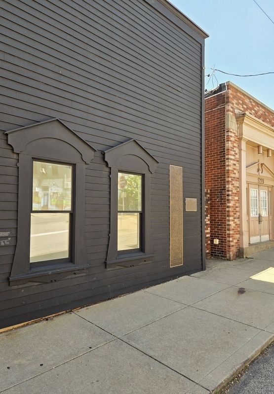
The marker is on the left.
Inscription.
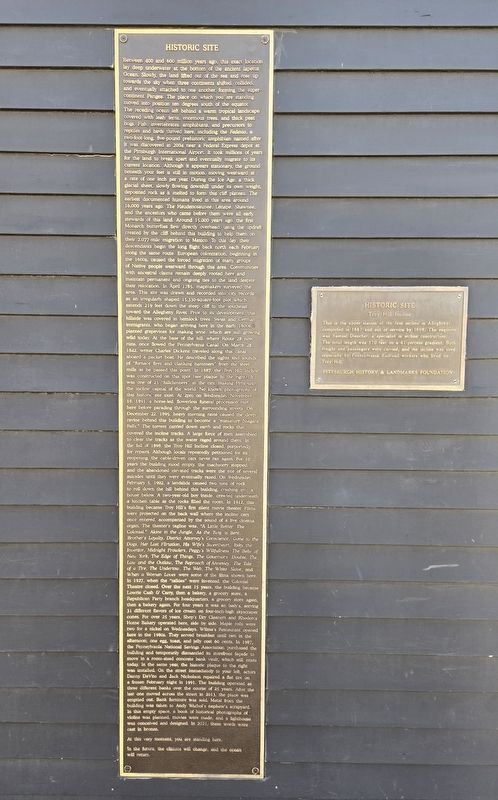
Historic Site. . , Between 400 and 600 million years ago, this exact location lay deep underwater at the bottom of the ancient Iapetus Ocean. Slowly, the land lifted out of the sea and rose up towards the sky when three continents shifted, collided, and eventually attached to one another, forming the super-continent Pangea. The place on which you are standing moved into position ten degrees south of the equator. The receding ocean left behind a warm tropical landscape covered with leafy ferns, enormous trees, and thick peat bogs. Fish, invertebrates, amphibians, and precursors to reptiles and birds thrived here, including the Fedexia, a two-foot-long, five-pound prehistoric amphibian named after it was discovered in 2004 near a Federal Express depot at the Pittsburgh International Airport. It took millions of years for the land to break apart and eventually migrate to its current location. Although it appears stationary, the ground beneath your feet is still in motion, moving westward at a rate of one inch per year. During the Ice Age, a thick glacial sheet, slowly flowing downhill under its own weight, deposited rock as it melted to form this cliff plateau. The earliest documented humans lived in this area around 16,000 years ago. The Haudenosaunee, Lenape, Shawnee, and the ancestors who came before them were all early stewards of this land. Around 15,000 years ago, the first Monarch butterflies flew directly overhead, using the updraft created by the cliff behind this building to help them on their 2,077-mile migration to Mexico. To this day, their descendants begin the long flight back north each February along the same route. European colonization, beginning in the 1600s, caused the forced migration of many groups of Native people westward through this area. Communities with ancestral claims remain deeply rooted here and maintain permanent and ongoing ties to the land despite their relocation. In April 1785, mapmakers surveyed the area. This site was drawn and recorded into city records as an irregularly shaped 15,330-square-foot plot which extends 219 feet down the steep cliff to the southeast, toward the Allegheny River. Prior to its development, this hillside was covered in hemlock trees. Swiss and German immigrants, who began arriving here in the early 1800s, planted grapevines for making wine, which are still growing wild today. At the base of the hill, where Route 28 now runs, once flowed the Pennsylvania Canal. On March 28, 1842, writer Charles Dickens traveled along this canal aboard a packet boat. He described the sights and sounds of "furnace fires and clanking hammers" from the steel mills as he passed this point. In 1887, the Troy Hill Incline was constructed on this spot (see plaque to the right). It was one of 23 "hillclimbers" in the city, making Pittsburgh the incline capital of the world. No known photographs of this historic site exist. At 2pm on Wednesday, November 18, 1891, a horse-led, flowerless funeral procession met here before parading through the surrounding streets. On December 22, 1895, heavy morning rains caused the deep ravine behind this building to become a "miniature Niagara Falls." The torrent carried down earth and rocks that covered the incline tracks. A large force of men assembled to clear the tracks as the water raged around them. In the fall of 1898, the Troy Hill Incline closed, purportedly for repairs. Although locals repeatedly petitioned for its reopening, the cable-driven cars never ran again. For 10 years the building stood empty, the machinery stopped, and the abandoned elevated tracks were the site of several suicides until they were eventually razed. On Wednesday, February 5, 1902, a landslide caused two tons of rock to roll down the hill behind this building, crashing into a house below. A two-year-old boy inside, crawled underneath a kitchen table as the rocks filled the room. In 1912, this building became Troy Hill's first silent movie theater. Films were projected on the back wall where the incline cars once entered, accompanied by the sound of a live cinema organ. The theater's tagline was, "A Little Better: The Colonial." Alone in the Jungle, As the Twig is Bent, Brother's Loyalty, District Attorney's Conscience, Gone to the Dogs, Her Last Flirtation, His Wife's Sweetheart, Itsky the Inventor, Midnight Prowlers, Peggy's Willfullness, The Belle of New York, The Edge of Things, The Governor's Double, The Law and the Outlaw, The Reproach of Annesley, The Tale of a Tire, The Undertow, The Web, The White Slave, and When a Woman Loves were some of the films shown here. In 1927, when the "talkies" were invented, the Colonial Theatre closed. Over the next 15 years, the building became Lowrie Cash and Carry, then a bakery, a grocery store, a Republican Party branch headquarters, a grocery store again, then a bakery again. For four years it was an Isaly's, serving 31 different flavors of ice cream on four-inch-high skyscraper cones. For over 25 years, Shep's Dry Cleaners and Rhoden's Home Bakery operated here, side by side. Maple rolls were two for a nickel on Wednesdays. Wilma's Restaurant opened here in the 1980s. They served breakfast until two in the afternoon; one egg, toast, and jelly cost 60 cents. In 1987, the Pennsylvania National Savings Association purchased the building and temporarily dismantled its storefront façade to move in a room-sized concrete bank vault, which still exists today. In the same year, the historic plaque to the right was installed. On the street immediately to your left, actors Danny DeVito and Jack Nicholson repaired a flat tire on a frozen February night in 1991. The building operated as three different banks over the course of 25 years. After the last one moved across the street in 2013, the place was emptied out. Bank furniture was sold. Metal from the building was taken to Andy Warhol's nephew's scrapyard. In this empty space, a book of historical photographs of violins was planned, movies were made, and a lighthouse was conceived and designed. In 2021, these words were cast in bronze., At this very moment, you are standing here., In the future, the climate will change, and the ocean will return.
Between 400 and 600 million years ago, this exact location lay deep underwater at the bottom of the ancient Iapetus Ocean. Slowly, the land lifted out of the sea and rose up towards the sky when three continents shifted, collided, and eventually attached to one another, forming the super-continent Pangea. The place on which you are standing moved into position ten degrees south of the equator. The receding ocean left behind a warm tropical landscape covered with leafy ferns, enormous trees, and thick peat bogs. Fish, invertebrates, amphibians, and precursors to reptiles and birds thrived here, including the Fedexia, a two-foot-long, five-pound prehistoric amphibian named after it was discovered in 2004 near a Federal Express depot at the Pittsburgh International Airport. It took millions of years for the land to break apart and eventually migrate to its current location. Although it appears stationary, the ground beneath your feet is still in motion, moving westward at a rate of one inch per year. During the Ice Age, a thick glacial sheet, slowly flowing downhill under its own weight, deposited rock as it melted to form this cliff plateau. The earliest documented humans lived in this area around 16,000 years ago. The Haudenosaunee, Lenape, Shawnee, and the ancestors who came before them were all early stewards of this land. Around 15,000 years ago, the first Monarch butterflies flew directly overhead, using the updraft created by the cliff behind this building to help them on their 2,077-mile migration to Mexico. To this day, their descendants begin the long flight back north each February along the same route. European colonization, beginning in the 1600s, caused the forced migration of many groups of Native people westward through this area. Communities with ancestral claims remain deeply rooted here and
Click or scan to see this page online
maintain permanent and ongoing ties to the land despite their relocation. In April 1785, mapmakers surveyed the area. This site was drawn and recorded into city records as an irregularly shaped 15,330-square-foot plot which extends 219 feet down the steep cliff to the southeast, toward the Allegheny River. Prior to its development, this hillside was covered in hemlock trees. Swiss and German immigrants, who began arriving here in the early 1800s, planted grapevines for making wine, which are still growing wild today. At the base of the hill, where Route 28 now
runs, once flowed the Pennsylvania Canal. On March 28, 1842, writer Charles Dickens traveled along this canal aboard a packet boat. He described the sights and sounds
of "furnace fires and clanking hammers" from the steel mills as he passed this point. In 1887, the Troy Hill Incline was constructed on this spot (see plaque to the right). It was one of 23 "hillclimbers" in the city, making Pittsburgh the incline capital of the world. No known photographs of this historic site exist. At 2pm on Wednesday, November 18, 1891, a horse-led, flowerless funeral procession met here before
Photographed by Bradley Owen, April 28, 2025
2. Historic Site Marker
parading through the surrounding streets. On December 22, 1895, heavy morning rains caused the deep ravine behind this building to become a "miniature Niagara Falls." The torrent carried down earth and rocks that covered the incline tracks. A large force of men assembled to clear the tracks as the water raged around them. In the fall of 1898, the Troy Hill Incline closed, purportedly for repairs. Although locals repeatedly petitioned for its reopening, the cable-driven cars never ran again. For 10 years the building stood empty, the machinery stopped, and the abandoned elevated tracks were the site of several suicides until they were eventually razed. On Wednesday, February 5, 1902, a landslide caused two tons of rock to roll down the hill behind this building, crashing into a house below. A two-year-old boy inside, crawled underneath a kitchen table as the rocks filled the room. In 1912, this building became Troy Hill's first silent movie theater. Films were projected on the back wall where the incline cars once entered, accompanied by the sound of a live cinema organ. The theater's tagline was, "A Little Better: The Colonial." Alone in the Jungle, As the Twig is Bent, Brother's Loyalty, District Attorney's Conscience, Gone to the Dogs, Her Last Flirtation, His Wife's Sweetheart, Itsky the Inventor, Midnight Prowlers, Peggy's Willfullness, The Belle of New York, The Edge of Things, The Governor's Double, The Law and the Outlaw, The Reproach of Annesley, The Tale of a Tire, The Undertow, The Web, The White Slave, and When a Woman Loves were some of the films shown here. In 1927, when the "talkies" were invented, the Colonial Theatre closed. Over the next 15 years, the building became Lowrie Cash & Carry, then a bakery, a grocery store, a Republican Party branch headquarters, a grocery store again, then a bakery again. For four years it was an Isaly's, serving 31 different flavors of ice cream on four-inch-high skyscraper cones. For over 25 years, Shep's Dry Cleaners and Rhoden's Home Bakery operated here, side by side. Maple rolls were two for a nickel on Wednesdays. Wilma's Restaurant opened here in the 1980s. They served breakfast until two in the afternoon; one egg, toast, and jelly cost 60 cents. In 1987, the Pennsylvania National Savings Association purchased the building and temporarily dismantled its storefront façade to move in a room-sized concrete bank vault, which still exists today. In the same year, the historic plaque to the right was installed. On the street immediately to your left, actors Danny DeVito and Jack Nicholson repaired a flat tire on a frozen February night in 1991. The building operated as three different banks over the course of 25 years. After the last one moved across the street in 2013, the place was emptied out. Bank furniture was sold. Metal from the building was taken to Andy Warhol's nephew's scrapyard. In this empty space, a book of historical photographs of violins was planned, movies were made, and a lighthouse was conceived and designed. In 2021, these words were cast in bronze.
At this very moment, you are standing here.
In the future, the climate will change, and the ocean will return.
Location. 40° 27.872′ N, 79° 58.918′ W. Marker is in Pittsburgh, Pennsylvania, in Allegheny County. It is in Troy Hill. It is at the intersection of Lowrie Street and Froman Street, on the right when traveling north on Lowrie Street. Touch for map. Marker is at or near this postal address: 1733 Lowrie Street, Pittsburgh PA 15212, United States of America. Touch for directions.
Regionally, this marker is in the American Northeast, in the Mid-Atlantic, in the Ohio River Valley, in Appalachia, and specifically in Northern Appalachia. Globally, it is in North America, the Western Hemisphere, the Western World, and the Anglosphere. Historically, it finds itself in what was once the Viceroyalty of New France, the Haudenosaunee (Iroquois) Confederacy, and one of the original Thirteen Colonies.
Credits. This page was last revised on May 7, 2025. It was originally submitted on May 7, 2025, by Bradley Owen of Morgantown, West Virginia. This page has been viewed 193 times since then and 57 times this year. Photos:1, 2. submitted on May 7, 2025, by Bradley Owen of Morgantown, West Virginia.