
Otterville in Cooper County, Missouri — The American Midwest (Upper Plains)
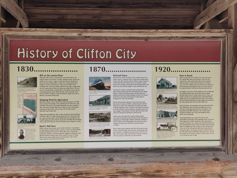
History of Clifton City
Photographed by John Ridley, April 26, 2023
1. History of Clifton City Marker
1830…
Mill on the Lamine River
Although Clifton City is a railroad town, the Lamine River is the original reason for the town's location. George Cranmer of Paris, Ky., settled on the Lamine in 1832, at what later became the Missouri, Kansas & Texas Railway (MKT or Katy) river crossing. With James Glasgow, Cranmer built Cranmer's (later Corum's) Mill, which produced flour, meal and lumber. Named for the cliffs, or high bluffs, over the nearby Lamine River, the town was called Clifton. The river was first named Riviere a la Mine (River of the Mine) around 1720 by a prospecting party under Phillip Renault, director-general of the French colonies in America. Renault looked for copper and silver in Missouri, but found mainly lead.
Shipping Point for Agriculture
With the railroad's arrival, Clifton City made fast progress. The MKT built outward from Sedalia, first southwest to Fort Scott, Kan., then northeast to Boonville. This Sedalia-Boonville line was surveyed in 1871, and tracks reached Clifton City on April 10, 1873. Track-laying continued at about half a mile per day, and the Katy reached Boonville seven weeks later.
Clifton
this page online
Devil's Half-Acre
Clifton City was once known as the "Devil's Half-Acre." According to the 1876 History of Cooper County, a grocery in town sold bad whiskey, probably distilled from raw corn, which often led to "skirmishes." During the Civil War, oral history evidence suggests Confederate raider William Quantrill used this part of the county as a place of refuge. After the war, bank robbers Jesse and Frank James, who served under Quantrill, may have done the same.
1870…
Railroad Towns
Most towns and cities in America were founded along rivers, wagon routes or railroads–that is, along major transportation routes of the 18th and 19th centuries. Missouri towns along the old Katy Railroad, like Clifton City, are no exception. Larger places such as Sedalia and Boonville were transportation hubs, where river and railroad merged, or two railroad lines met.
Small places, however, made the truest railroad towns. Many towns along the Katy Trail State Park like Green Ridge, Beaman, Clifton City, Pleasant Green and Pilot Grove were platted around the time Katy tracklayers arrived. The railroad preferred to have stops spaced about 10 miles apart to resupply trains with coal and water.
But the railroad towns became far more than train stops. Katy towns in Cooper and Pettis counties became important agricultural centers from which grain and cattle were taken to distant markets by train. They had a full range of businesses to be self-sufficient, cultural activities, and good schools and even colleges. They boomed in the late 1800s and early 1900s when the railroad was dominant in American life.
Farther east on the Katy Trail, along the Missouri River, many other towns thrived with the Katy and declined with is disappearance. Wainwright, Tebbetts, Steedman, McKittrick, Gore and Peers not only depended on the railroad for their creation, but were even named after railroad investors or officers.
Most of these places along the Katy Trail still show the traces of their railroad heritage. Here and there, old building fronts, grain elevators or telegraph poles give hints of the busy old days, when wheat, hogs and wood were shipped out by rail and new products arrived from around the world.
1920…
Rails to Roads
Greater prosperity came to Clifton City in the early 1900s. The original MKT depot burned down in 1907 and was replaced by a slate-roofed depot. Many locals worked in Sweeney Quarry–visible from the Katy Trail at milepost 212.7–one of the largest in the area, which sent crushed and block limestone around Missouri and out of state. Some of the original ballast of the Katy rail bed was quarried here.
Cue Higdon's mule barn on the southeast corner of highways 135 and 88 shipped mules around the country. Higdon provided larger mules to wheat, cotton and corn areas, and smaller animals to rice-growing areas. During World War I, Higdon had an army contract for pack mules. Local histories say that despite qualifications for age, height and soundness, the army rejected only one mule from Clifton City.
During the 1920s, two passenger trains went through Clifton City, westbound in the morning and eastbound at 11 P.M. The town claimed three general stores, two doctors, two blacksmith shops, two drugstores, and a lumber yard, stockyard, hardware store, bank, pay telephone office, barber shop and garage.
The garage business was a sign of the future. Soon automobiles took business from passenger trains, and trucks from freight trains. Clifton City farmers who had used the railroad to ship their corn, wheat, oats, hay and livestock had other transportation choices. A farm-to-market road connecting Route E to highway 50, built in 1934-35, was the beginning of the end for the railroad and other town businesses that had grown with it. The last day of school in Clifton City was in 1951. Mt. Moriah African Methodist Episcopal Church, serving its members for more than a century, closed in 1974. The last run of a Katy train was in 1987.
Erected by Missouri Department of Natural Resources.
Topics and series. This historical marker is listed in these topic lists: Railroads & Streetcars • Settlements & Settlers. In addition, it is included in the African Methodist Episcopal (AME) Church, and the Katy Trail State Park series lists. A significant historical date for this entry is April 10, 1873.
Location. 38° 45.839′ N, 93° 2.715′ W. Marker is in Otterville, Missouri, in Cooper County. It can be reached from Katy Trail west of County Highway BB, on the right when traveling west. Touch for map. Marker is at or near this postal address: 5455 Highway 135, Otterville MO 65348, United States of America. Touch for directions.

Regionally, this marker is in the Missouri River Corridor. It is also in the American Midwest, in the Lewis & Clark Corridor, in the Corn Belt, and on the Santa Fe Trail Corridor. Globally, it is in North America, the Western Hemisphere, the Western World, and the Anglosphere. Historically, it finds itself in what was once the territory of the Mississippian Culture, the Louisiana Purchase, and the Antebellum South.
Other nearby markers. At least 8 other markers are within 11 miles of this marker, measured as the crow flies: Rise and Fall of the Osage Empire (here, next to this marker); Sedalia's Rag Tag Train (approx. 10.2 miles away); Katy Depot (approx. 10.2 miles away); Katy Trail State Park 25th Anniversary (approx. 10.3 miles away); History of Sedalia (approx. 10.3 miles away); Sedalia Points of Interest (approx. 10.3 miles away); Sedalia to Clifton City (approx. 10.3 miles away); Sedalia to Green Ridge (approx. 10.3 miles away).
Credits. This page was last revised on August 5, 2025. It was originally submitted on May 13, 2025, by John Ridley of Chelsea, Michigan. This page has been viewed 280 times since then and 98 times this year. Photo 1. submitted on May 13, 2025, by John Ridley of Chelsea, Michigan. • Devry Becker Jones was the editor who published this page.
Editor’s want-list for this marker. A wide shot of the marker in context. • Can you help?
