Marker Logo
THE HISTORICAL
MARKER DATABASE
“Bite-Size Bits of Local, National, and Global History”
Point Edward in Lambton County, Ontario — Central Canada (North America)
 

Founding of Point Edward


Founding of Point Edward Marker image. Click for full size.
Photographed by Tim Boyd, May 12, 2025
1. Founding of Point Edward Marker
Inscription. In 1838 John Slocum, a native of New York, established a commercial fishery on the site of a former military reserve here where the St. Clair River flows out of Lake Huron. The area remained sparsely populated until 1859 when it became the crossing point into the U. S. for the Grand Trunk Railway. Rapid development followed and in 1864 a town plan was laid out for the community called Point Edward, reportedly after Queen Victoria's father, Edward, Duke of Kent. In 1870 a steamship service was inaugurated to transport immigrants and supplies to western Canada and by 1873 the town contained stores, hotels, sawmills and large immigration sheds. Five years later it was incorporated as a Village with a population of more than one thousand.
 
Erected by Ontario Heritage Foundation.
 
Topics and series. This historical marker is listed in these topic lists: Railroads & StreetcarsSettlements & Settlers. In addition, it is included in the Canada, Ontario Heritage Trust series list. A significant historical year for this entry is 1838.
 
Location. 42° 59.897′ N, 82° 24.804′ W. Marker is in Point Edward, Ontario, in Lambton
Paid Advertisement
Click or scan to see
this page online
County. It is at the intersection of Saint Clair Street and Michigan Avenue, on the left when traveling north on Saint Clair Street. The marker is attached to the east side of the Point Edward Library. Touch for map. Marker is at or near this postal address: 30a St Clair Street, Point Edward ON N7V N7V, Canada. Touch for directions.

Regionally, this marker is in the Southwest Ontario Area and in Southwestern Ontario. It is also in Central Canada. Globally, it is in North America, the Western Hemisphere, the Western World, and the Anglosphere. Historically, it finds itself in what was once a British colony, the Viceroyalty of New France, the Haudenosaunee (Iroquois) Confederacy, and Rupert’s Land.

Other nearby markers. At least 8 other markers are within walking distance of this marker: The Voyage of the Griffon 1679 (approx. 0.7 kilometers away); Robert Earl Campbell (approx. 0.7 kilometers away); The Tuskegee Airmen Memorial (approx. 0.9 kilometers away in the U.S.); Great Storm of 1913 and Sailors Memorial (approx. 0.9 kilometers away in the U.S.); The "John S. Martin" (approx. 0.9 kilometers away in the U.S.);
Founding of Point Edward Marker image. Click for full size.
Photographed by Tim Boyd, May 12, 2025
2. Founding of Point Edward Marker
Native American Monument (approx. one kilometer away in the U.S.); Traversing The River (approx. one kilometer away in the U.S.); Bridging the Blue Waters (approx. one kilometer away in the U.S.). Touch for a list and map of all markers in Point Edward.
 
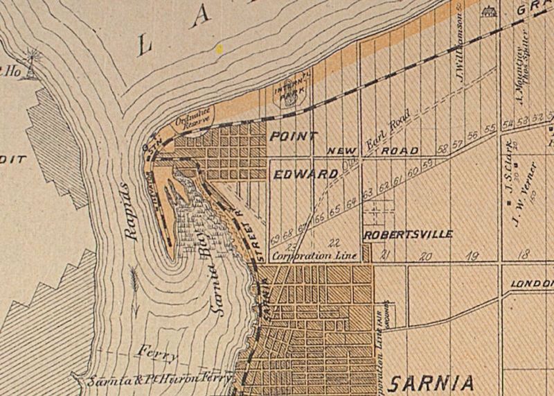
Point Edward in 1879 image. Click for full size.
3. Point Edward in 1879
Historical Atlas of Lambton County (McGill university)
 
 
Credits. This page was last revised on December 21, 2025. It was originally submitted on May 18, 2025, by Tim Boyd of Hamilton, Ontario. This page has been viewed 109 times since then and 22 times this year. Photos:   1, 2, 3. submitted on May 18, 2025, by Tim Boyd of Hamilton, Ontario. • Andrew Ruppenstein was the editor who published this page.

m=272778

CeraNet Cloud Computing sponsors the Historical Marker Database.
This website earns income from purchases you make after using our links to Amazon.com. We appreciate your support.
Paid Advertisement
Jul. 28, 2026
