Duck Key in Monroe County, Florida — The American South (South Atlantic)
Historic Duck Key Bridges

Photographed by Tim Fillmon, May 14, 2025
1. Historic Duck Key Bridges Marker
Before 1951, Duck Key was an isolated island with minor salt production and cultivation of sea cotton. In 1951, Miami developer Bryan W. Newkirk Sr. and his business partners, Telfair Knight, Robert Eugene Otto, and his son, Bryan W. Newkirk Jr. began developing Duck Key. Originally one large island, a series of canals were dredged to divide it into five separate islands (Indies, Centre, Harbour, Plantation, and Yacht Club) connected by four ornately designed bridges. Otto, a Key West-based artist, designed each island to have a unique style and theme. Otto and Bryan W. Newkirk Jr. also designed the four bridges to connect the islands. The bridge designs, inspired by bridges in Venice, Italy, were ornately designed with decorative railings, pineapple and papaya finials, and steep curved profiles. The main resort at Duck Key, the Indies House, was designed by architect Morris Lapidus. Duck Key was a popular destination for celebrities and politicians. The first bridge connecting Indies Island was renamed the Truman Bridge in 1964 in commemoration of President Harry Truman who was a frequent visitor to Duck Key. The
this page online
Erected 2020 by Monroe County and the Florida Department of State. (Marker Number F-1118.)
Topics. This historical marker is listed in this topic list: Bridges & Viaducts. A significant historical year for this entry is 1951.
Location. 24° 46.388′ N, 80° 54.848′ W. Marker is in Duck Key, Florida, in Monroe County. It is at the intersection of Duck Drive (at milepost 61) and Greenbriar Road, on the right when traveling south on Duck Drive. Touch for map. Marker is at or near this postal address: 1128 Greenbriar Rd, Marathon FL 33050, United States of America. Touch for directions.

Regionally, this marker is on the Florida Keys. It is also in the American South and on the Gulf Coast. Globally, it is in the North Atlantic Region, North America, a Gulf of Mexico state, the Western Hemisphere, the Western World, and the Anglosphere. Historically, it finds itself in what was once New Spain, the territory of the Mississippian Culture, one of the Confederate States of America, and the Antebellum South.
Other nearby markers. At least 8 other markers are within

Photographed by Tim Fillmon, May 14, 2025
2. Historic Duck Key Bridges Marker
More about this marker. Located on Duck Key Drive just before the Truman Bridge—where the road transitions into Bimini Drive—a historical marker contains an inaccuracy. Although all four of Duck Key's bridges were rehabilitated in 1982, only three were ultimately replaced in 2021. The Truman Bridge was also scheduled for replacement, but it was spared after being certified as structurally sound. Because the sign was erected before this decision was finalized, it fails to reflect that the Truman Bridge was left intact—retaining its original construction and standing as the island's sole surviving historic span.
Also see . . . Truman Bridge. (Submitted on May 20, 2025, by Tim Fillmon of Webster, Florida.)
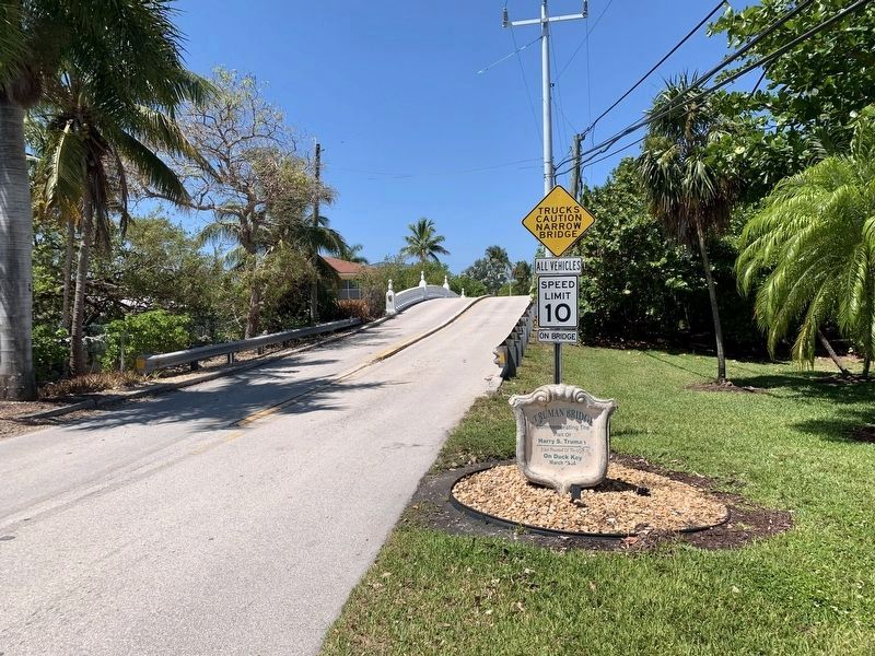
Photographed by Tim Fillmon, May 14, 2025
3. Truman Bridge
Credits. This page was last revised on September 5, 2026. It was originally submitted on May 20, 2025, by Tim Fillmon of Webster, Florida. This page has been viewed 260 times since then and 83 times this year. Last updated on September 5, 2026, by Melinda Wittekind of Cocoa Beach, Florida. Photos: 1, 2, 3. submitted on May 20, 2025, by Tim Fillmon of Webster, Florida. • Bernard Fisher was the editor who published this page.
