Appalachia in Wise County, Virginia — The American South (Mid-Atlantic)
Trail Head
Town of Appalachia
—
Powell River Trail
—
Photographed by J. J. Prats, May 16, 2025
1. Trail Head Marker
Inscription.
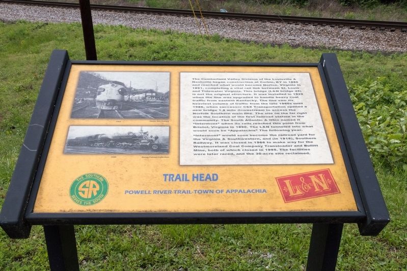
Trail Head. Town of Appalachia. The Cumberland Valley Division of the Louisville and Nashville began construction at Corbin, Ky in 1886 and reached what would become Norton, Virginia, in 1891, completing a vital rail link between St. Louis and Tidewater Virginia. This bridge (L&N bridge 45) when the line was upgraded to handle heavy coal traffic from eastern Kentucky. The line saw its heaviest volume of traffic from the late 1960s until 1986, when successor CSX Transportation opened a new bridge 1.8 mile downstream to access the Norfolk Southern main line. The site on the far right was the location of the first railroad station in the community. The South Atlantic and Ohio named it “Intermont” when its rails reached this point from Bristol, Virginia in 1890. The L&N tunneled into what would soon be “Appalachia” The following year. , “Intermont” would soon become the railroad yard for the Virginia and Southwestern, and (in 1916), Southern Railway. It was closed in 1966 to make way for the Westmoreland Coal Company Transloader and Bullitt Mine, both of which closed in 1995. The facilities were later razed, and the 30-acre site reclaimed.
The Cumberland Valley Division of the Louisville &
Nashville began construction at Corbin, Ky in 1886
and reached what would become Norton, Virginia, in
1891, completing a vital rail link between St. Louis
and Tidewater Virginia. This bridge (L&N bridge 45)
when the line was upgraded to handle heavy coal
traffic from eastern Kentucky. The line saw its
heaviest volume of traffic from the late 1960s until
1986, when successor CSX Transportation opened a
new bridge 1.8 mile downstream to access the
Norfolk Southern main line.
The site on the far right
was the location of the first railroad station in the
community. The South Atlantic & Ohio named it
“Intermont” when its rails reached this point from
Bristol, Virginia in 1890. The L&N tunneled into what
would soon be “Appalachia” The following year.
“Intermont” would soon become the railroad yard for
the Virginia & Southwestern, and (in 1916), Southern
Railway. It was closed in 1966 to make way for the
Westmoreland Coal Company Transloader and Bullitt
Mine, both of which closed in 1995. The facilities
were later razed, and the 30-acre site reclaimed.
Topics.
Click or scan to see this page online
This historical marker is listed in this topic list: Railroads & Streetcars. A significant historical year for this entry is 1886.
Location. 36° 53.964′ N, 82° 47.351′ W. Marker is in Appalachia, Virginia, in Wise County. It can be reached from West Main Street (Business U.S. 24) 0.2 miles west of Inman Street, on the right when traveling south. Touch for map. Marker is at or near this postal address: 751 W Main St, Appalachia VA 24216, United States of America. Touch for directions.
Regionally, this marker is in Southwest Virginia. It is also in the American South, specifically in the Upper South, in Appalachia, and specifically in Southern Appalachia. Globally, it is in the North Atlantic Region, North America, the Western Hemisphere, the Western World, and the Anglosphere. Historically, it finds itself in what was once the original Cherokee Nation, the territory of the Mississippian Culture, one of the original Thirteen Colonies, one of the Confederate States of America, and the Antebellum South.
Other nearby markers. At least 8 other markers are within 3 miles of this marker, measured as the crow flies: The Bee Rock Troll
Photographed by J. J. Prats, May 16, 2025
2. Trail Head and Marker
U.S. Business 23 runs below the bridge on its way through Big Stone Gap to the town of Big Stone Gap, about 2½ miles away.
Regarding Trail Head. The Powell River Trailhead in the town of Appalachia has a paved parking lot, restroom facilities and is handicap-accessible to the reasonably level 2.4 mile 10-foot wide out-and-back trail. The trail features two tunnels, the Bee Rock Tunnel and the Callahan Tunnel. Interpretive panels along the trail narrates the history of the trail.
Credits. This page was last revised on May 27, 2025. It was originally submitted on May 27, 2025, by J. J. Prats of Powell, Ohio. This page has been viewed 137 times since then and 23 times this year. Photos:1, 2. submitted on May 27, 2025, by J. J. Prats of Powell, Ohio.
Editor’s want-list for this marker. The other markers along the trail, each on their own page • Can you help?