Mackinaw City in Emmet County, Michigan — The American Midwest (Great Lakes)
The early European history of this land
Photographed by Craig Doda, May 25, 2025
1. The early European history of this land Marker
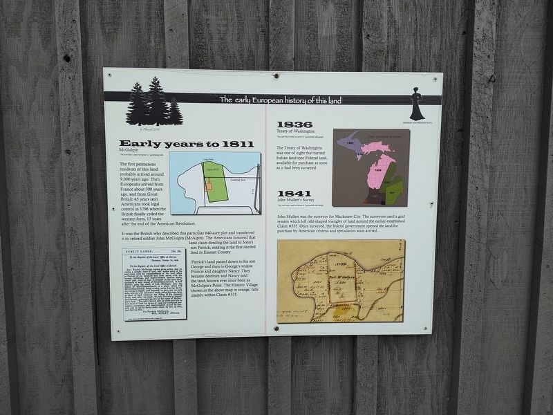
Early years to 1811
McGulpin
"You can't buy it until we survey it," government tells
The first permanent residents of this land probably arrived around 9,000 years ago. Then Europeans arrived from France about 300 years ago, and from Great Britain 45 years later. Americans took legal control in 1796 when the British finally ceded the western forts, 13 years after the end of the American Revolution.
It was the British who described this particular 640-acre plot and transferred it to retired soldier John McGulpin (McAlpin). The Americans honored that land claim deeding the land to John's son Patrick, making it the first deeded land in Emmet County.
Patrick's land passed down to his son George and then to George's widow Francis and daughter Nancy. They became destitute and Nancy sold the land, known ever since been as McGulpin's Point. The Historic Village, shown in the above map in orange, falls mainly within Claim # 335.
1836
Treaty of Washington
"You can't buy it until we survey it," government tells people.
The Treaty of Washington was one of eight that turned Indian land into Federal land, available for purchase
this page online
1841
John Mullett's Survey
"You can't buy it until we survey it," government tells people
John Mullett was the surveyor for Mackinaw City. The surveyors used a grid system which left odd-shaped triangles of land around the earlier established Claim # 335. Once surveyed, the federal government opened the land for purchase by American citizens and speculators soon arrived.
[Captions:]
Public Lands.
[No. 135,
To the Register of the Land Office at Detroit.
Detroit, October 19, 1800.
To the Register of the Land Office at Detroit. SIR: Patrick McGulpin hereby gives notice that he claims a certain tract of land, and makes entry of his said claim with the commis mmissioners of the Innd office at Detroit, of six hundred and forty acres, with the houses, buildings, and improvements thereon, made; which said tract of land is situated on the main land, southerly of said island of Michillimackinack, in said district, upon the strait of Lake Michigan, near the island of Michillimackinack, at a place called Old Michillimackinack, being twenty acres front by thirty- two acres in depth, and bounded in part, and on each side, and rear, by unlocated lands, be of the claimant er tract of land whereon the Patrick by himself lived, and, after his death, the by the name of McGul. and tenants, commonly known by the claim and title to pin's farm. The said Patrof long and continued pos said tract of land by movements in and by him- session, occupancy, and self, and in and by those under whom he sets up title, and derives title.
For Patrick McGulfin,
Sol. Sibley, Attorney.
From American State Papers, Vol. 1, page 374
Erected 2016
Photographed by Craig Doda, May 25, 2025
2. The early European history of this land Marker
Topics. This historical marker is listed in this topic list: Settlements & Settlers. A significant historical date for this entry is October 19, 1800.
Location. 45° 46.621′ N, 84° 46.236′ W. Marker is in Mackinaw City, Michigan, in Emmet County. It is at the intersection of Headlands Road and Wilderness Park Drive, on the right when traveling west on Headlands Road. Touch for map. Marker is at or near this postal address: 1425 W Central Ave, Mackinaw City MI 49701, United States of America. Touch for directions.

Regionally, this marker is in Northern Michigan Lower Peninsula, on the Straits of Mackinac, and in one of the Lake Michigan Shore counties. It is also in the American Midwest. Globally, it is in North America, in the Great North Woods, on the Great Lakes, in the Western Hemisphere, in the Western World, and in the Anglosphere. Historically, it finds itself in what was once the Viceroyalty of New France and also the Northwest Territory.
Other nearby markers. At least 8 other markers are within walking distance of this marker: The modern history of this land (here, next to this marker); Mackinaw's General Store (a few steps from this marker); Sawmill (a few steps from this marker); Heritage Chapel (within shouting distance of this marker); Walk the Path to the Hidden Native Settlement (within shouting distance of this marker); Pest House (within shouting distance of this marker); Two Machines (within shouting distance of this marker); Ice Harvesting (within shouting distance of this marker). Touch for a list and map of all markers in Mackinaw City.
Credits. This page was last revised on June 2, 2025. It was originally submitted on May 30, 2025, by Craig Doda of Napoleon, Ohio. This page has been viewed 90 times since then and 18 times this year. Photos: 1, 2. submitted on May 30, 2025, by Craig Doda of Napoleon, Ohio. • Devry Becker Jones was the editor who published this page.
