Mackinaw City in Emmet County, Michigan — The American Midwest (Great Lakes)
Mackinaw's General Store
You Need It? We Have It!
Photographed by Craig Doda, May 25, 2025
1. Mackinaw's General Store Marker
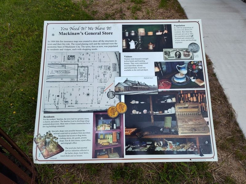
In 1884 this fire insurance map was created to show all the structures in town and their fire risk. The wood planing mill and the railroad were the economic base of Mackinaw City. The town, then as now, was populated by residents and visitors, each with shopping needs.
Residents
For the workers' families, the town had two grocery stores, a church, and school. The families lived in dwellings (dwg) scattered about town. Most were of frame construction but a few log buildings remained.
Specialty shops were possible because the railroad could deliver products from anywhere. Residents had access to drug stores, clothing stores, dry goods, jewelry shops, boot & shoe stores, a post office, and telegraph office.
The town also had assorted service industries reflected in the barber shops, local farms, wood sheds and ice houses.
Population
In 1880 the population of the town was about 275 residents. But when the railroads arrived in 1881, the population quickly doubled and construction of new stores and dwellings exploded.
Visitors
Visitors were housed overnight in five hotels and boarding houses. They were entertained in
this page online
Erected 2020 by Mackinaw Area Historical Society & Heritage Village.
Topics. This historical marker is listed in this topic list: Industry & Commerce. A significant historical year for this entry is 1884.
Location. 45° 46.616′ N, 84° 46.245′ W. Marker is in Mackinaw City, Michigan, in Emmet County. It is at the intersection of Headlands Road and Wilderness Park Drive, on the right when traveling west on Headlands Road. Touch for map. Marker is at or near this postal address: 1425 W Central Ave, Mackinaw City MI 49701, United States of America. Touch for directions.

Regionally, this marker is in Northern Michigan Lower Peninsula, on the Straits of Mackinac, and in one of the Lake Michigan Shore counties. It is also in the American Midwest. Globally, it is in North America, in the Great North Woods, on the Great Lakes, in the Western Hemisphere, in the Western World, and in the Anglosphere. Historically, it finds itself in what was once the Viceroyalty of New France and also the Northwest Territory.
Other nearby markers. At least 8 other
Photographed by Craig Doda, May 25, 2025
2. Mackinaw's General Store Marker
Photographed by Craig Doda, May 25, 2025
3. Mackinaw's General Store Marker
Credits. This page was last revised on June 2, 2025. It was originally submitted on May 30, 2025, by Craig Doda of Napoleon, Ohio. This page has been viewed 109 times since then and 19 times this year. Photos: 1, 2, 3. submitted on May 30, 2025, by Craig Doda of Napoleon, Ohio. • Devry Becker Jones was the editor who published this page.
