Mackinaw City in Emmet County, Michigan — The American Midwest (Great Lakes)
Mackinaw City's Schools
Photographed by Craig Doda, May 25, 2025
1. Mackinaw City's Schools Marker
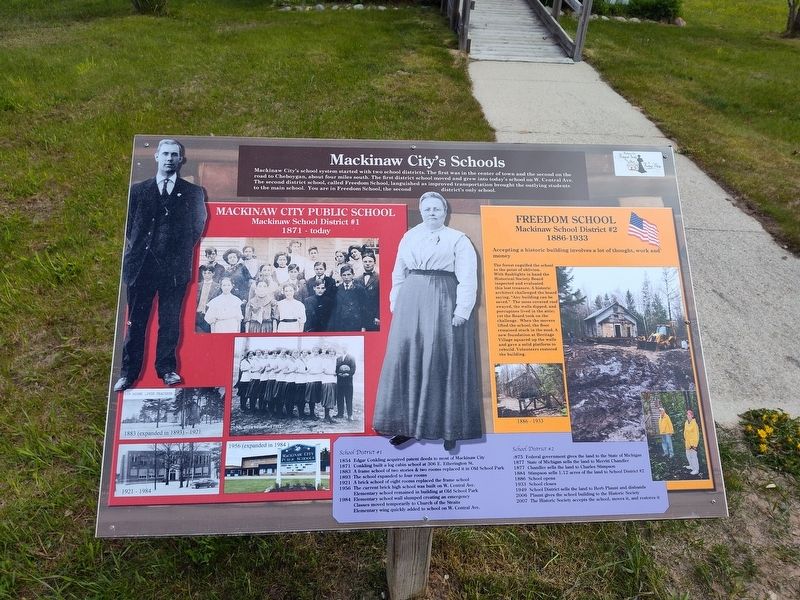
Mackinaw City's school system started with two school districts. The first was in the center of town and the second on the road to Cheboygan, about four miles south. The first district school moved and grew into today's school on W. Central Ave. The second district school, called Freedom School, languished as improved transportation brought the outlying students to the main school. You are in Freedom School, the second district's only school.
Mackinaw School District #2
1886-1933
The forest engulfed the school to the point of oblivion. With flashlights in hand the Historical Society Board inspected and evaluated this lost treasure. A historic architect challenged the board. saying, "Any building can be saved." The moss covered roof swayed, the walls dipped, and porcupines lived in the attic; vet the Board took on the challenge. When the movers. lifted the school, the floor remained stuck in the mud. A new foundation at Heritage Village squared up the walls and gave a solid platform to rebuild. Volunteers restored the building.
School District #1
1854Edgar Conkling acquired patent deeds to most of Mackinaw City
Click or scan to see
this page online
1871 Conkling built a log cabin school at 306 E. Etherington St.
1883 A frame school of two stories & two rooms replaced it in Old School Park
1893 The school expanded to four rooms
1921 A brick school of eight rooms replaced the frame school
1956 The current brick high school was built on W. Central Ave. Elementary school remained in building at Old School Park
1984 Elementary school wall slumped creating an emergency Classes moved temporarily to Church of the Straits Elementary wing quickly added to school on W. Central Ave.
School District #2
1875 Federal government gives the land to the State of Michigan.
1877 State of Michigan sells the land to Merritt Chandler
1877 Chandler sells the land to Charles Stimpson
1884 Stimpson sells 1.12 acres of the land to School District #2
1886 School opens
1933 School closes
1949 School District sells the land to Herb Plaunt and disbands
2006 Plaunt gives the school building to the Historic Society
2007 The Historic Society accepts the school, moves it, and restores it
Topics. This historical marker is listed in this topic list: Architecture. A significant historical year for this entry is 1854.
Location. 45° 46.617′ N, 84° 46.327′ W. Marker is in Mackinaw City, Michigan, in Emmet County. It is at the intersection of Headlands Road and Wilderness Park Drive, on the right when traveling west on Headlands Road. Touch for map. Marker is at or near this postal address: 1425 W Central Ave, Mackinaw City MI 49701, United States of America. Touch for directions.

Regionally, this marker is in Northern Michigan Lower Peninsula, on the Straits of Mackinac, and in one of the Lake Michigan Shore counties. It is also in the American Midwest. Globally, it is in North America, in the Great North Woods, on the Great Lakes, in the Western Hemisphere, in the Western World, and in the Anglosphere. Historically, it finds itself in what was once the Viceroyalty of New France and also the Northwest Territory.
Other nearby markers. At least 8 other markers are within walking distance of this marker: Freedom School (here, next to this marker); 3-Seater (within shouting distance of this marker); Two Machines (within shouting distance of this marker); Pest House (within shouting distance of this marker); Chasing a Dream (within shouting distance of this marker); Walk the Path to the Hidden Native Settlement (within shouting distance of this marker); Native American Waganogan (within shouting distance of this marker); Simple Two-Story Farm House 1882 (about 300 feet away, measured in a direct line). Touch for a list and map of all markers in Mackinaw City.
Credits. This page was last revised on June 2, 2025. It was originally submitted on May 30, 2025, by Craig Doda of Napoleon, Ohio. This page has been viewed 82 times since then and 29 times this year. Photo 1. submitted on May 30, 2025, by Craig Doda of Napoleon, Ohio. • Devry Becker Jones was the editor who published this page.
