Totnes in Devon, England, United Kingdom — Northwestern Europe (the British Isles)
Welcome to The Market Square
Photographed by Ray Gurganus, April 6, 2025
1. Welcome to The Market Square Marker
History of the Market Square
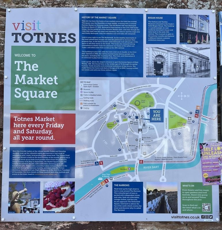
This site has been the home of our markets since the town has existed. The square was the Shambles or meat market, evolving into a covered Pannier Market in Victorian times. The old Market Hall was destroyed by fire on March 17, 1955. Believed to have started in the Civic Hall house, the fire gutted all of the Pannier Market stalls, and even though the Civic Hall itself was left intact and standing, the interior and the stage area was totally destroyed. Only the asbestos root and walls still remained.
Look to your right to see The Butterwalk. As the wealthy merchants of the town jettied their houses out over the pavement to increase their property size, so the dairy farmers and milkmaids took advantage of the space to sell their wares in the shade. The locals also enjoyed having somewhere to shelter from the elements too! Some of the pillars are Tudor, and others date from as late as the 18th century.
The building to your left with the town crest on its facade, is the Civic Hall. Opened in 1960, the hall has hosted many famous people over the years, including U2, Courtney Pine, The Cure,
this page online
Look up left, above the sloped entrance to spot the bronze figure of Mary Wesley, CBE She found fame at the tender age of 70 through the quirky humour, frank sexuality and emotional turbulence of her novels. She made Totnes her home and died at the age of 90 in 2002, having written ten novels and sold over three million copies.
Bogan House
The Fashion and Textiles Museum is housed in the Grade 1 listed Bogan House. The building is a good example of a late medieval merchant's house and dates back to the early 15th century. The museum is open in the summer months and features a different historic costume exhibition every year.
Topics. This historical marker is listed in this topic list: Industry & Commerce.
Location. 50° 25.891′ N, 3° 41.365′ W. Marker is in Totnes, England, in Devon. It is on High Street. Touch for map. Marker is at or near this postal address: 44 High Street, Totnes, England TQ9 5NP, United Kingdom. Touch for directions.

Regionally, this marker is in South West England. Globally, it is on the Atlantic Ocean, in the North Atlantic Region, in Europe, in Atlantic Europe, on one of the British Isles, in the Western World, and in the Anglosphere. Historically, it finds itself in what was once the Roman Empire.
Other nearby markers. At least 8 other markers are within 10 kilometers of this marker, measured as the crow flies: Ann Ball (about 90 meters away, measured in a direct line); The Medieval Town of Totnes (about 120 meters away); The Shell Keep (about 150 meters away); The Castle Bailey (about 180 meters away); The Shady Garden (approx. 0.3 kilometers away); Totnes Town Mill (approx. half a kilometer away); The Posts of the Town Marsh Gate (approx. half a kilometer away); Paignton: Episcopal Manor, Town and Palace (approx. 8.5 kilometers away). Touch for a list and map of all markers in Totnes.
Credits. This page was last revised on June 10, 2025. It was originally submitted on June 4, 2025, by Ray Gurganus of Washington, District of Columbia. This page has been viewed 117 times since then and 28 times this year. Photo 1. submitted on June 4, 2025, by Ray Gurganus of Washington, District of Columbia. • Andrew Ruppenstein was the editor who published this page.
Editor’s want-list for this marker. photo of the marker within its surroundings • Can you help?
