Near Spotsylvania Courthouse in Spotsylvania County, Virginia — The American South (Mid-Atlantic)
Catharine Furnace
The Battle of Chancellorsville
— Fredericksburg and Spotsylvania National Military Park —
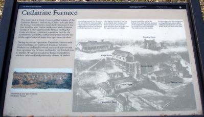
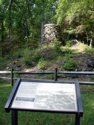
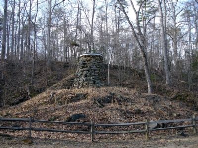
The stone stack in front of you is all that remains of the Catharine Furnace, built in 1837. Closed a decade later, the furnace was reborn to meet the Confederacy’s wartime need for iron. Union cavalrymen under General George A. Custer destroyed the furnace in 1864, but it was rebuilt and continued to produce iron for the Confederacy until 1865. Catharine Furnace was the last of the region’s several major operations to close.
During its years of operation, Catharine Furnace used many buildings and employed dozens of laborers. Workers cut and hauled wood, excavated iron ore and lime, operated the furnace, and hauled the finished iron to market. When not needed for furnace operations, workers cultivated land previously cleared of timber.
(Sidebar) Iron-making required four elements: iron ore, limestone, charcoal, and a source of power. Fueled by charcoal and fanned by a bellows, the furnace reached temperatures in excess of 2,800 degrees. Deposits of iron ore were dumped down the stack onto the fire. Lime was then added to draw impurities from the molten iron. The super-heated iron and lime deposits melted and ran out the bottom of the stack. Workers skimmed off the impurities (slag) and channeled the purified iron into sand molds. The solid iron bars that resulted, known as pigs, were then transported to a forge elsewhere, where skilled craftsmen fashioned them into pots, kettles, tools and other useful items.
Erected by National Park Service, U.S. Department of the Interior.
Topics. This historical marker is listed in these topic lists: Industry & Commerce • War, US Civil. A significant historical year for this entry is 1837.
Location. 38° 17.336′ N, 77° 38.882′ W. Marker is near Spotsylvania Courthouse, Virginia, in Spotsylvania County. Marker is at the intersection of Jackson Trail East and Sickles Drive, on the right when traveling south on Jackson Trail East. Jackson Trail East is an unpaved road. Marker is at the junction of Furnance Road, Sickles Drive and Jackson Trail East. Touch for map. Marker is at or near this postal address: 11699 Jackson Trail E, Spotsylvania VA 22553, United States of America. Touch for directions.
Other nearby markers. At least 8 other markers are within walking distance of this marker. A Region of Gloom (here, next to this marker); Jackson's Flank March (here, next to this marker); Chancellorsville Campaign (approx. 0.2 miles away); About a mile in the distance... (approx. half a mile away); Birthplace of Matthew Fontaine Maury (1806-1873) (approx. half a mile away); Maury Birthplace (approx. half a mile away); a different marker also named Chancellorsville Campaign (approx. 0.6 miles away); Maury House Trail (approx. 0.6 miles away). Touch for a list and map of all markers in Spotsylvania Courthouse.
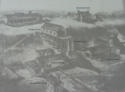
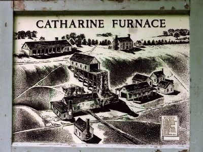
More about this marker. The right side of the marker, including the sidebar, displays a drawing of the furnace as it appeared in operation. Important buildings are annotated on the drawing. On the lower left is a a photo "detail of an iron 'pig' produced at Catharine Furnace."
Regarding Catharine Furnace. This is one of several markers for the Battle of Chancellorsville along McLaws Drive, Furnace Road, Sickles Drive, and East Jackson Trail, on the east side of the battlefield. See the McLaws's Line to Catharine Furnace Virtual Tour by Markers in the links section for a listing of related markers on the tour.
Also see . . .
1. Battle of Chancellorsville. National Parks Service site. (Submitted on November 17, 2007, by Craig Swain of Leesburg, Virginia.)
2. Archaeology at Catharine Furnace. (Submitted on November 17, 2007, by Craig Swain of Leesburg, Virginia.)
3. McLaws's Line to Catharine Furnace Virtual Tour by Markers. Spread across a two mile segment
on the east side of the battlefield, this virtual tour by markers covers action from May 1-3, 1863. (Submitted on November 15, 2007, by Craig Swain of Leesburg, Virginia.)
Credits. This page was last revised on July 9, 2021. It was originally submitted on September 29, 2007. This page has been viewed 1,770 times since then and 45 times this year. Last updated on October 28, 2020. Photos: 1. submitted on September 29, 2007. 2. submitted on November 17, 2007, by Craig Swain of Leesburg, Virginia. 3. submitted on November 4, 2014, by David Graff of Halifax, Nova Scotia. 4, 5. submitted on September 29, 2007. • Bernard Fisher was the editor who published this page.
