Fort Totten in Queens in Queens County, New York — The American Northeast (Mid-Atlantic)
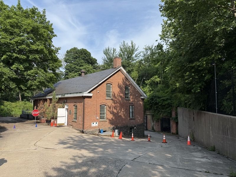
502 Lee Road
Constructed in 1900

Original use: Ordnance Shop
Current use: Visitors' Center/Urban Park Rangers Queens Headquarters
Building 502 was constructed as an ordnance shop for the shop for the assembly and repair of harbor mines (then called torpedoes) and other artillery. It was strategically located next to the torpedo magazines as well as a tunnel that leads down to the Water Battery. A railway from the tunnel allowed for easy access to the water. A wooden elevator provided an innovative means of transferring torpedo components between the three floors of the building.
[Caption:]
Learn More From the Rangers
Building 502 has been under the command of the Urban Park Rangers as the Fort Totten Visitors' Center since 2008. Park patrons can learn about the park's military past as well as the natural history of our parks and our city's diverse urban wildlife. When the center is open, come find out how you can visit Fort Totten's historic Water Battery!
Erected by NYC Parks.
Topics and series. This historical marker is listed in this topic list: Forts and Castles. In addition, it is included in the NYC Parks series list. A significant historical year for this entry is 2008.
Location. 40° 47.728′ N,
this page online

Regionally, this marker is in New York City and on Long Island. It is also in the American Northeast, in the Mid-Atlantic, and on the Eastern Seaboard. Globally, it is in the North Atlantic Region, North America, the Western Hemisphere, the Western World, and the Anglosphere. Historically, it finds itself in what was once New Netherland and also one of the original Thirteen Colonies.
Other nearby markers. At least 8 other markers are within walking distance of this marker: Battery King (about 300 feet away, measured in a direct line); 422 Weaver Ave. (approx. 0.2 miles away); Parade Ground (approx. 0.2 miles away); 638 Totten Ave. (approx. 0.2 miles away); 207 Totten Ave. (approx. 0.2 miles away); Thorne-Wilkins Cemetery (approx. 0.2 miles away); Fort Totten (approx. 0.2 miles

Other markers no longer nearby. Fort Totten Park (was about 400 feet away but has been permanently removed); Main Magazine of Fort Totten (was about 500 feet away but has been permanently removed).

Photographed by Devry Becker Jones (CC0), June 8, 2025
4. Signage inside the building for The Ordnance Building's elevator
This building is strategically located adjacent to the torpedo vaults, batteries, and main magazine. It was constructed in 1900 and was used for assembling and maintaining the "torpedoes", or underwater miens, and other artillery.
This elevator was used to move the torpedo components between the three floors. This elevator car is a simple structure, constructed of 4 x 6-foot wooden planks and connected by steel rivets and strips. There are no walls or doors on this elevator. A wood beam and affixed steel harness above the car, called the crosshead, spans the elevator shaft from side to side and holds the hoist cable. The car and its load were lifted by a 1-inch thick metal cable that was attached to the cross-head at one end, and traveled up to the ceiling around an overhead sheave, or pulley and was probably attached to a counterweight at the other end. The hoisting rope was wound over the drum and down to the counterweight. The counterweight adds accelerating force when the elevator car is ascending and provides a retarding effort when the car is descending. The counterweight is a collection of metal weights that is equal to the weight of the car containing about 45% of its rated load.
John Roebling introduced the manufacture of wire rope in America, primarily for bridges. He was one of the first innovators to provide wire rope for the elevator industry in 1862. If you peek through the window to the basement floor, you can still see the cab that was lifted by the thick metal cable.
Also visible are the wooden 2 x 2 -inch guide rails that run the length of the shaft. These keep the car and counterweight from swaying or twisting during their travel. The guide rail was constructed of wood, and the elevator part that connected to it was made of steel. Rollers might have been attached to the car and the counterweight to provide smooth travel along the guide rails.
Notice the floor where the elevator would have stopped to unload its cargo, and note the notches in the walls. it is speculated that these were probably used as part of the braking system. The elevator was probably stopped at each floor and rested in these notches for safety.
Looking at the floorboards above and below you, you will notice small holes in the wood. These are all in line on all three floors, and are a part of an intricate pulley system. If you look up to the attic above you, you can still see the remnants of this pulley system. You can still see the gears and the 6-foot wheel are safely secured.
This elevator was used to move the torpedo components between the three floors. This elevator car is a simple structure, constructed of 4 x 6-foot wooden planks and connected by steel rivets and strips. There are no walls or doors on this elevator. A wood beam and affixed steel harness above the car, called the crosshead, spans the elevator shaft from side to side and holds the hoist cable. The car and its load were lifted by a 1-inch thick metal cable that was attached to the cross-head at one end, and traveled up to the ceiling around an overhead sheave, or pulley and was probably attached to a counterweight at the other end. The hoisting rope was wound over the drum and down to the counterweight. The counterweight adds accelerating force when the elevator car is ascending and provides a retarding effort when the car is descending. The counterweight is a collection of metal weights that is equal to the weight of the car containing about 45% of its rated load.
John Roebling introduced the manufacture of wire rope in America, primarily for bridges. He was one of the first innovators to provide wire rope for the elevator industry in 1862. If you peek through the window to the basement floor, you can still see the cab that was lifted by the thick metal cable.
Also visible are the wooden 2 x 2 -inch guide rails that run the length of the shaft. These keep the car and counterweight from swaying or twisting during their travel. The guide rail was constructed of wood, and the elevator part that connected to it was made of steel. Rollers might have been attached to the car and the counterweight to provide smooth travel along the guide rails.
Notice the floor where the elevator would have stopped to unload its cargo, and note the notches in the walls. it is speculated that these were probably used as part of the braking system. The elevator was probably stopped at each floor and rested in these notches for safety.
Looking at the floorboards above and below you, you will notice small holes in the wood. These are all in line on all three floors, and are a part of an intricate pulley system. If you look up to the attic above you, you can still see the remnants of this pulley system. You can still see the gears and the 6-foot wheel are safely secured.
Credits. This page was last revised on June 19, 2025. It was originally submitted on June 19, 2025, by Devry Becker Jones of Washington, District of Columbia. This page has been viewed 161 times since then and 54 times this year. Photos: 1, 2, 3, 4. submitted on June 19, 2025, by Devry Becker Jones of Washington, District of Columbia.
