Bentonville in Benton County, Arkansas — The American South (West South Central)
The Oaks
⎯⎯⎯
Congressman Samuel West Peel
Photographed by Marc Hayot, June 30, 2026
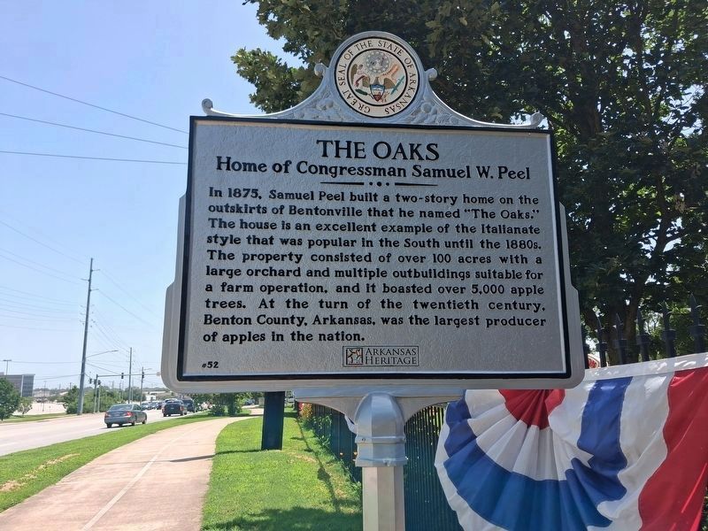
1. The Oaks / Congressman Samuel West Peel Marker
The Oaks
Home of Congressman Samuel W. Peel
In 1875, Samuel Peel built a two-story home on the outskirts of Bentonville that he named “The Oaks.” The house is an excellent example of the Italianate style that was popular in the South until the 1880s. The property consisted of over 100 acres with a large orchard and multiple outbuildings suitable for a farm operation, and it boasted over 5,000 apple trees. At the turn of the twentieth century, Benton County, Arkansas, was the largest producer of apples in the nation.
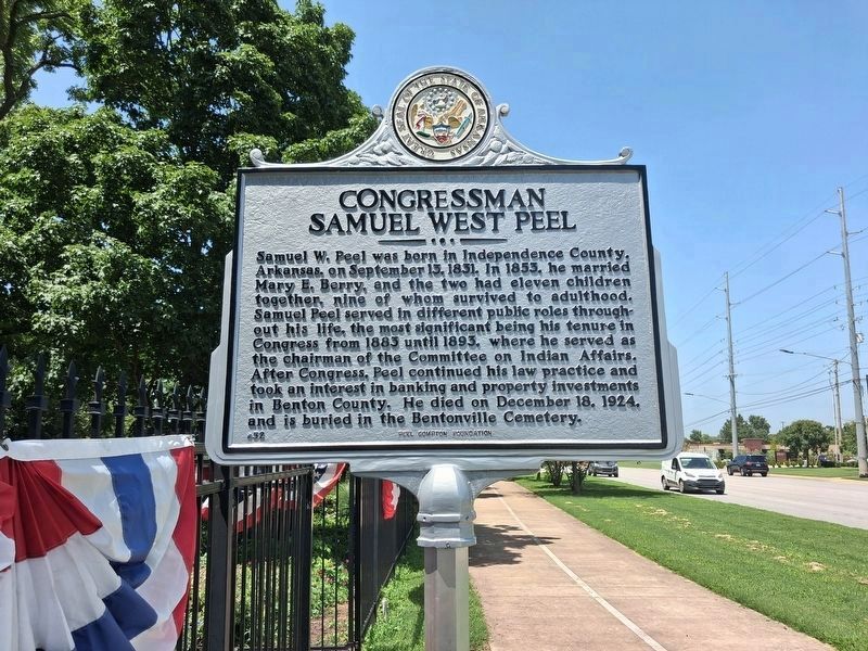
Congressman Samuel West Peel
Samuel W. Peel was born in Independence County, Arkansas, on September 13, 1831. In 1853, he married Mary E. Berry, and the two had eleven children together, nine of whom survived to adulthood. Samuel Peel served in different public roles throughout his life, the most significant being his tenure in Congress from 1883 until 1893, where he served as the chairman of the Committee on Indian Affairs. After Congress, Peel continued his law practice and took an interest in banking and property investments in Benton County. He died on December 18, 1924, and is buried in the
this page online
Erected 2025 by Arkansas Heritage; Peel Compton Foundation. (Marker Number 52.)
Topics and series. This historical marker is listed in these topic lists: Architecture • Government & Politics. In addition, it is included in the Arkansas Heritage series list.
Location. 36° 22.144′ N, 94° 13.317′ W. Marker is in Bentonville, Arkansas, in Benton County. It is on South Walton Boulevard (U.S. 71B) ¼ mile south of W Central Avenue, on the right when traveling south. By the front gate of the Peel Museum beside the Greenway bike trail which runs along Walton Boulevard. Touch for map. Marker is at or near this postal address: 400 S Walton Boulevard, Bentonville AR 72712, United States of America. Touch for directions.

Regionally, this marker is in Northwest Arkansas, on the Ozark Plateau, in the Cherokee Heritage Region, and in Osage Territory. It is also in the American South, specifically in the Upper South, and in the Ozarks. Globally, it is in North America, the Western Hemisphere, the Western World, and the Anglosphere. Historically, it finds
Photographed by Marc Hayot, June 30, 2026
2. The Oaks / Congressman Samuel West Peel Marker
Other nearby markers. At least 8 other markers are within walking distance of this marker: Col. Samuel W. Peel House (within shouting distance of this marker); Confederate Memorial (approx. 0.3 miles away); Craig-Bryan House (approx. 0.6 miles away); Eagle Hotel (approx. 0.7 miles away); Meteor Theatre (approx. 0.7 miles away); Benton County National Bank (approx. 0.7 miles away); Frisco Depot (approx. ¾ mile away); Benton County Hardware (approx. ¾ mile away). Touch for a list and map of all markers in Bentonville.
Another marker is no longer nearby. Big Tree (was within shouting distance of this marker but has been permanently removed).
Also see . . . Peel Museum and Botanical Garden (Encyclopedia of Arkansas). (Submitted on June 27, 2025.)

Photographed by Chelsea Stewart, May 31, 2025
3. Side 1: The Oaks: Home of Congressman Samuel W. Peel

Photographed by Chelsea Stewart, May 31, 2025
4. Side 2: Congressman Samuel West Peel
Credits. This page was last revised on July 9, 2026. It was originally submitted on June 26, 2025, by Ashley Sides of Little Rock, Arkansas. This page has been viewed 171 times since then and 57 times this year. Photos: 1, 2. submitted on June 30, 2026, by Marc Hayot of Siloam Springs, Arkansas. 3, 4. submitted on June 26, 2025, by Ashley Sides of Little Rock, Arkansas. • Andrew Ruppenstein was the editor who published this page.
