Tracy City in Grundy County, Tennessee — The American South (East South Central)
Company Bath House and Latrine
Civilian Conservation Corps Company 1475, Camp S-67, Tracy City
Photographed by Darren Jefferson Clay, June 22, 2025
1. Company Bath House and Latrine Marker
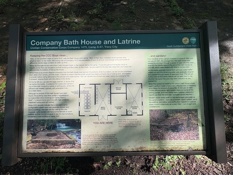
Here, on the southern edge of Camp S-67, was the Bath House and Latrine. Most of their days consisted of doing hard, dirty, physical labor, so the nearly 200 young men of Company 1475 required plenty of room to shower, and enough sinks and toilets to efficiently handle large numbers at clean-up time.
Water for the bath house came from Little Gizzard Creek, in the canyon below the camp. It was brought to this facility using an electric pump that was housed in a small building at Blue Hole, on the creek. As you walk the Grundy Day Loop trail, you'll pass the old concrete foundation of that pump house.
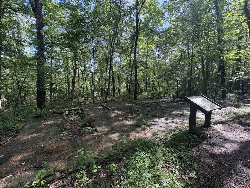
While there is no known diagram of exactly how the bath house was laid out, the remains of its foundation, as well as documentation from other CCC camps, provide clues. It stands to reason that the water would have been pumped into a holding tank, and heated in a boiler before being delivered to the shower and wash rooms. You can identify the shower and wash rooms by looking for the X-shaped, sloping floors with the drains in the center.
At the far left you can see the large channel, or sluice,
this page online
Although no photos of this bath house have been found, the building was likely similar in appearance to most of the other buildings at "Camp Alvin C. York" a wood frame structure with high windows, clapboard siding and roll roofing.
While CCC records indicate that a standard camp configuration would have had separate shower and latrine buildings, that was not the case at this site. However, camp leaders did have some latitude on such matters, and so it is not unusual to see the two functions combined in one building at Camp S-67.
...and sanitary!
From the time of the camp's inception in June of 1935 until January of 1937, the sewage from this bath house was treated by running it through a series of open pits that were dug into the hillside beyond the end of the bath house, to your left, which were treated with lime to control odor.
As the waste gradually moved from pit to pit, solid matter settled out and the remaining water was gradually
Photographed by Darren Jefferson Clay, June 22, 2025
2. Company Bath House and Latrine Marker
While this system for treating the camp's bath house waste wasn't perfect, it was a reasonably effective way of cleaning up a messy by-product of camp life. In January of 1937, a more efficient septic tank system replaced some of the settling ponds, and flush toilets were installed, Inspection reports say that the tank was "pumped out as required."
Modern septic tanks work on the same basic principles as the camp's system - but with a modern septic system, all of the settling, percolation and purification happens in special pipes, known collectively as a drain field out of sight and underground.
Photo caption (right): As you walk the Grundy Day Loop trail, look for the old concrete foundation at the base of the steps and footbridge next to Blue Hole. This is what remains of the CCC pump house that supplied water from Little Gizzard Creek to this bath house, as well as to the Camp's laundry facility, which you'll also see on this interpretive trail.
Image caption (center): This is a likely layout of the bath house, based on what can be seen by examining the foundation, combined with information from other CCC and military facilities of that period.
Photo caption (left): Don't be concerned these settling ponds haven't handled wastewater from the camp's bath house since 1938. Nature has long since neutralized any unpleasant microbes in these depressions.
Erected by South Cumberland State Park.
Topics and series. This historical marker is listed in this topic list: Charity & Public Work. In addition, it is included in the If You've Got to Go... series list. A significant historical month for this entry is January 1937.
Location. 35° 15.051′ N, 85° 45.137′ W. Marker is in Tracy City, Tennessee, in Grundy County. It can be reached from Fiery Gizzard Road. marker is located off the Grundy Day Loop trail and can be accessed from the northern trailhead of the Fiery Gizzard Trail. Touch for map. Marker is at or near this postal address: 131 Fiery Gizzard Rd, Tracy City TN 37387, United States of America. Touch for directions.

Regionally, this marker is in the Cumberland Plateau and in the Highland Rim. It is also in the American South, specifically in the Upper South, in Appalachia, and specifically in Southern Appalachia. Globally, it is in North America, the Western Hemisphere, the Western World, and the Anglosphere. Historically, it finds itself in what was once the territory of the Mississippian Culture, one of the Confederate States of America, and the Antebellum South.
Other nearby markers. At least 8 other markers are within walking distance of this marker: What Became of this Camp? (a few steps from this marker); The home of CCC Company 1475 (within shouting distance of this marker); Laundry and Leaders (within shouting distance of this marker); Keeping it Cool (within shouting distance of this marker); Herman Baggenstoss and the CCC (within shouting distance of this marker); Grease and Discipline (within shouting distance of this marker); Camp Mess Hall, Kitchen and Well (within shouting distance of this marker); Fire Towers and Fire Prevention (about 300 feet away, measured in a direct line). Touch for a list and map of all markers in Tracy City.
Credits. This page was last revised on July 3, 2025. It was originally submitted on June 27, 2025, by Darren Jefferson Clay of Duluth, Georgia. This page has been viewed 106 times since then and 14 times this year. Photos: 1, 2. submitted on June 30, 2025, by Darren Jefferson Clay of Duluth, Georgia. • James Hulse was the editor who published this page.
