Tracy City in Grundy County, Tennessee — The American South (East South Central)
Barracks Area
Civilian Conservation Corps Company 1475, Camp S-67, Tracy City
Photographed by Darren Jefferson Clay, June 22, 2025
1. Barracks Area Marker
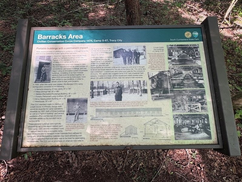
Here, based primarily on photographic evidence, is thought to be the first of a row (extending to your right) of four barracks.
Inspection reports from 1935 indicate there were four barracks buildings at this site, typical of the standard building complement of many CCC camps at this time.
By the time this camp was created in 1935, the CCC had abandoned its initial concept of conventional, permanent buildings, and had begun using an innovative system of portable buildings, consisting of six-foot modular sections that could be bolted together, to allow CCC companies to more easily move their camps to new locations, in order to remain close to their work projects.
In 1935, when this camp was created, the standard CCC camp configuration consisted of the following:
• 4 Barracks (sleeping 50 men each), 20' x 130
• 1 Mess (Dining) Hall, 20' x 180'
• 1 Welfare (Recreation/Exchange) Building, 30' x 120'
• 1 Forestry Personnel Living Quarters, 20' x 90'
• 1 Army Headquarters Building, 20' x 40'
• 1 Warehouse, 20' x 40'
This CCC standard made no mention of a bath house or infirmary,
this page online
These portable buildings were typically shipped by rail to the depot nearest each CCC camp. CCC records indicated it took 12 railroad cars to ship a complete camp, and 100 truckloads to transport those materials from railhead to camp site. While the building materials may have arrived by train, CCC policy specified that local labor was to be hired for assembling the structures. The CCC put an emphasis on what we now refer to as "buying local," in order to help the economies of the areas in which the CCC placed its camps.
From information contained in inspection reports, we know Camp S-67 consisted of the CCC's basic set of buildings, plus the bath house/latrine; an infirmary; a dynamite magazine; and what is thought to be an ice house adjacent to the site of the Mess Hall. The camp also had workshops, a warehouse, and motor pool area for the company's 23 trucks. The reports also suggest Camp S-67 had a baseball
Photographed by Darren Jefferson Clay, June 22, 2025
2. Barracks Area Marker
A look inside the buildings of Camp S-67
Photo caption (right): There are few good photos that provide a glimpse into the interiors of buildings at this camp. In the first two at right, you can clearly see that the roof trusses as held together with bolts, indicating that these were portable buildings. Camp inspection records confirm that this was, indeed, a portable camp.
Photo caption (center): Of all Camp S-67 photos uncovered so far, this one and a series of similar images, each with different CCC Boys in the foreground provides the best glimpse into the overall layout of the camp. The is particularly important, since no camp map or layout has yet been found.
Image caption (bottom, right): These architect's drawings, part of the National Park Service Historic American Buildings Survey, depict a still-standing barracks structure from a CCC camp in Colorado. Because of the CCC's emphasis on standardization and portability for its camp buildings, their bears very close resemblance to barracks structures from this camp, as seen in several of the photos on this page.
Photo caption (left): In this photo you can clearly see the modular sections that characterized CCC's portable buildings
Erected by South Cumberland State Park.
Topics. This historical marker is listed in this topic list: Charity & Public Work.
Location. 35° 15.139′ N, 85° 45.161′ W. Marker is in Tracy City, Tennessee, in Grundy County. It can be reached from Fiery Gizzard Road. This marker can be fond on the Grundy Day Loop Trail accessed via the northern trailhead of the Fiery Gizzard Trail. Touch for map. Marker is at or near this postal address: 351 Fiery Gizzard Rd, Tracy City TN 37387, United States of America. Touch for directions.

Regionally, this marker is in Tennessee’s Cumberland Plateau and in the Highland Rim. It is also in the American South, specifically in the Upper South, in Appalachia, and specifically in Southern Appalachia. Globally, it is in North America, the Western Hemisphere, the Western World, and the Anglosphere. Historically, it finds itself in what was once the territory of the Mississippian Culture, one of the Confederate States of America, and the Antebellum South.
Other nearby markers. At least 8 other markers are within walking distance of this marker: A Moment in Time (here, next to this marker); A Vital Asset to the Region (within shouting distance of this marker); Life in Company 1475 (within shouting distance of this marker); Fire Towers and Fire Prevention (about 300 feet away, measured in a direct line); Camp Mess Hall, Kitchen and Well (about 300 feet away); Herman Baggenstoss and the CCC (about 300 feet away); Grease and Discipline (about 300 feet away); Keeping it Cool (about 400 feet away). Touch for a list and map of all markers in Tracy City.
Credits. This page was last revised on July 1, 2025. It was originally submitted on June 27, 2025, by Darren Jefferson Clay of Duluth, Georgia. This page has been viewed 81 times since then and 10 times this year. Photos: 1, 2. submitted on June 30, 2025, by Darren Jefferson Clay of Duluth, Georgia. • James Hulse was the editor who published this page.
