Pontefract in West Yorkshire, England, United Kingdom — Northwestern Europe (the British Isles)
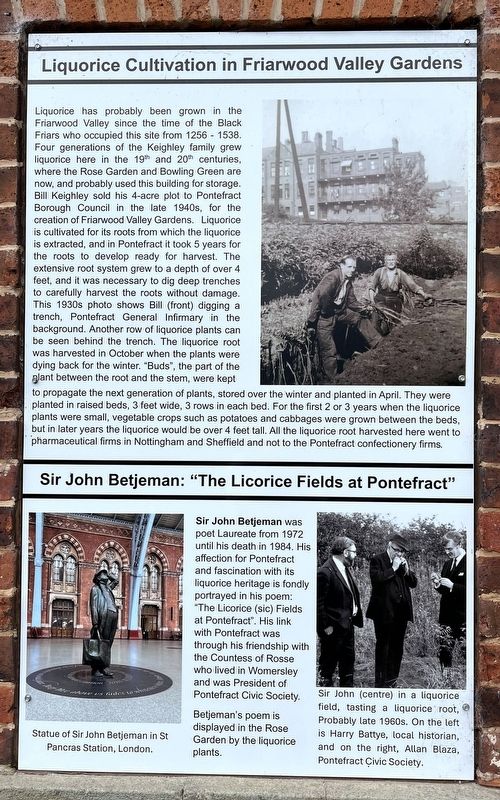
Liquorice Cultivation at Friarwood Valley Gardens
Photographed by Ray Gurganus, April 16, 2025
1. Liquorice Cultivation at Friarwood Valley Gardens Marker
Sir John Betjeman: "The Licorice Fields at Pontefract"
Statue of Sir John Betjeman in St Pancras Station, London. Sir John Betjeman was poet Laureate from 1972 until his death in 1984. His affection for Pontefract and fascination with its liquorice heritage
this page online
Betjeman's poem is displayed in the Rose Garden by the liquorice plants.
Sir John (centre) in a liquorice field, tasting a liquorice root, Probably late 1960s. On the left is Harry Battye, local historian, and on the right, Allan Blaza, Pontefract Civic Society.
Topics. This historical marker is listed in this topic list: Horticulture & Forestry. A significant historical year for this entry is 1256.
Location. 53° 41.359′ N, 1° 18.704′ W. Marker is in Pontefract, England, in West Yorkshire. It can be reached from Southgate. The marker is located in Friarwood Valley Gardens. Touch for map. Marker is at or near this postal address: A645, Pontefract, England WF8 1LN, United Kingdom. Touch for directions.

Regionally, this marker is in Yorkshire & The Humber. Globally, it is on the Atlantic Ocean, in the North Atlantic Region, in Europe, in Atlantic Europe, on one of the British Isles, in the Western World, and in the Anglosphere. Historically, it finds itself in what was once the Roman Empire.
Other nearby markers. At least 8 other markers are within walking distance of this marker: Liquorice (Glycyrrhiza glabra) (about 90 meters away, measured in a direct line); St Richard's Dominican Friary, Pontefract - 1256-1538 (about 120 meters away); Buttercross (about 210 meters away); Historic Market Place (approx. 0.3 kilometers away); Violet Pritchard, 1904-1974 (approx. 0.4 kilometers away); Peter & Fred Asquith (approx. 0.4 kilometers away); Flower Power (approx. 0.8 kilometers away); John de Lacy (approx. 0.8 kilometers away). Touch for a list and map of all markers in Pontefract.
Credits. This page was last revised on June 28, 2025. It was originally submitted on June 28, 2025, by Ray Gurganus of Washington, District of Columbia. This page has been viewed 100 times since then and 15 times this year. Photo 1. submitted on June 28, 2025, by Ray Gurganus of Washington, District of Columbia. • Andrew Ruppenstein was the editor who published this page.
Editor’s want-list for this marker. photo of the marker within its surroundings • Can you help?
