Winnfield in Winn Parish, Louisiana — The American South (West South Central)
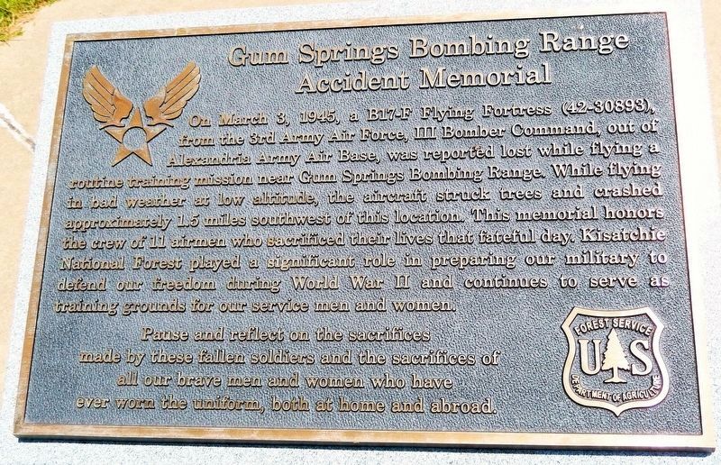
Gum Springs Bombing Range Accident Memorial
Photographed by Cosmos Mariner, June 28, 2025
1. Gum Springs Bombing Range Accident Memorial
(top panel)
(top panel)
[top panel]
On March 3, 1945, a B17-F Flying Fortress (42-30893), from the 3rd Army Air Force, III Bomber Command, out of Alexandria Army Air Base, was reported lost while flying a routine training mission near Gum Springs Bombing Range. While flying in bad weather at low altitude, the aircraft struck trees and crashed approximately 1.5 miles southwest of this location. This memorial honors the crew of 11 airmen who sacrificed their lives that fateful day. Kisatchie National Forest played a significant role in preparing our military to defend our freedom during World War II and continues to serve as training grounds for our service men and women.
Pause and reflect on the sacrifices made by these fallen soldiers and the sacrifices of all our brave men and women who have ever worn the uniform, both at home and abroad.
[front panel]
March 3, 1945
2nd Lieutenant Robert J. Keavy, Co-Pilot, 20 ~ Minneapolis, MN
2nd Lieutenant Omar H. Lauridsen, Navigator, 28 ~ Dedham, IA
2nd Lieutenant Bruno J. Wieclaw, Bombardier, 23 ~ Ravenna,
this page online
Technical Sergeant Alexander G. Harwood III, Radio Operator, 32 ~ Williamsburg, VA
Sergeant Harold D. Bush, Radio Operator, 23 ~ Salem, IN
Corporal Lester J. Smejkal, Gunner, 26 ~ Sturgeon Bay, WI
Corporal Jay “Joey” E. Crites, Engineer, 19 ~ San Bernardino, CA
Corporal Niels Anderson, Gunner, 19 ~ International Falls, MN
Private First Class Bruce C. Rue, Gunner, 19 ~ Benton Harbor, MI
Private First Class Millard B. Beaird, Gunner, 23 ~ Grand Junction, CO
Erected 2019 by Forest Service, U.S. Department of Agriculture.
Topics. This historical marker and memorial is listed in these topic lists: Air & Space • Disasters • Patriots & Patriotism • War, World II. A significant historical date for this entry is March 3, 1945.
Location. 31° 53.968′ N, 92° 46.957′ W. Marker is in Winnfield, Louisiana, in Winn Parish. It can be reached from U.S. 84 5 miles west of State Highway 1228, on the left when traveling west. The marker is located near the southwest corner of the U.S. Forest Service Winn Ranger District parking lot. Touch for map. Marker is at or near this postal address: 12319 US Highway 84, Winnfield LA 71483, United States

Photographed by Cosmos Mariner, June 28, 2025
2. Gum Springs Bombing Range Accident Memorial
(front panel)
(front panel)

Regionally, this marker and memorial is in Central Louisiana. It is also in the American South, specifically in the Deep South, and in the Piney Woods. Globally, it is in North America, a Gulf of Mexico state, the Western Hemisphere, the Western World, and the Anglosphere. Historically, it finds itself in what was once the territory of the Mississippian Culture, the Louisiana Purchase, one of the Confederate States of America, and the Antebellum South.
Other nearby markers. At least 8 other markers are within 9 miles of this marker, measured as the crow flies: William Edenborn (approx. 7 miles away); Natchitoches - Natchez Road (approx. 8 miles away); First United Methodist Church (approx. 8½ miles away); Huey Pierce Long (approx. 8.6 miles away); Bank of Winnfield & Law Office of Huey P. Long (approx. 8.7 miles away); Bernstein Building (approx. 8.7 miles away); Long-Tison (approx. 9.1 miles away); Earl Kemp Long (approx. 9.1 miles away). Touch for a list and map of all markers in Winnfield.
Also see . . . 1945 – March 3, USAAF B-17F too-low plane crash in heavy rain, near Winnfield, LA– 11.

Photographed by Cosmos Mariner, June 28, 2025
3. Gum Springs Bombing Range Accident Memorial
The marker panels are mounted on the top and front sides of this granite pedestal.
(by Rickey Robertson) Excerpt: During World War II thousands of American air crews and pilots trained at the many Army Air Force Bases in Louisiana. Airmen were trained to fly observation planes, fighter planes, and both light and heavy bombers. Due to this extensive training and continuous use of these aircraft, there were crashes that injured and killed many of these servicemen training for combat. One such accident took place in Winn Parish in the community of Gum Springs where the Army Air Forces had several practice bombing and gunnery ranges.(Submitted on July 9, 2025, by Cosmos Mariner of Cape Canaveral, Florida.)
On March 3, 1945 a B-17 F Model number 42-30893 assigned to the 3rd Air Force, III Bomber Command 89th Wing, 329th AAF Base Unit left on an instrument training mission to the bombing ranges outside Winnfield near the Gum Springs Community. The bomber took off late in the day of March 3, 1945 and turned toward Winnfield. The skies began to darken as a weather front slowly came through the area. When the bomber arrived over the target area, right at dark, it flew right into the path of a cold front. The cold front brought forth severe thunderstorms that greatlyhampered the visibility of the pilot and crew, with the base weather section advising of less than two miles of visibility and closing. As the weather got worse the B-17 turned due west as the crew tried to outrun and fly under the weather front. The B-17 dropped down in an attempt to get under the weather front so it could make a turn east/southeast to get back to its home. According to the crash accident report from the Army Air Forces, it was noted that the B-17 had gotten so low that it struck a sixty-five-foot-tall pine tree, shearing off the left wing, causing the plane to crash into the ground. Army Engineers built a quick road into the area. This road is still located in the National Forest and is named "Plane Road." Army Air Force personnel arrived and recovered the bodies of the eleven crew members and began their investigation of the crash.Photographed by Cosmos Mariner, June 28, 20254. Gum Springs Bombing Range Accident MemorialThe U.S. Forest Service Winn Ranger District office is in the right background.


Photographed by Cosmos Mariner, June 28, 2025
5. U.S. Forest Service Winn Ranger District Office
Turn south here from US Highway 84 to access the marker. This is also the entrance to the Gum Springs Campground and Picnic Area.
Credits. This page was last revised on September 4, 2026. It was originally submitted on June 29, 2025, by Cosmos Mariner of Cape Canaveral, Florida. This page has been viewed 268 times since then and 101 times this year. Photos: 1, 2, 3, 4, 5. submitted on July 8, 2025, by Cosmos Mariner of Cape Canaveral, Florida.
