Near Bertram in Burnet County, Texas — The American South (West South Central)
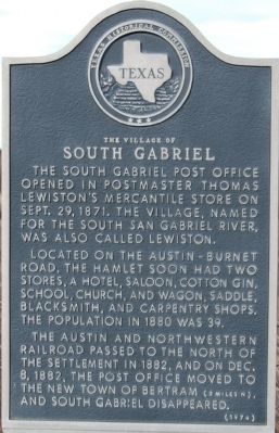
The Village of South Gabriel
The South Gabriel Post Office opened in Postmaster Thomas Lewiston's mercantile store on Sept. 29, 1871. The village, named for the South San Gabriel River, was also called Lewiston.
Located on the Austin-Burnet Road, the hamlet soon had two stores, a hotel, saloon, cotton gin, school, church, and wagon, saddle, blacksmith, and carpentry shops. The population in 1880 was 39.
The Austin and Northwestern Railroad passed to the north of the settlement in 1882, and on Dec. 8, 1882, the post office moved to the new town of Bertram (2 miles N) and South Gabriel disappeared.
Erected 1974 by Texas Historical Commission. (Marker Number 9748.)
Topics and series. This historical marker is listed in this topic list: Settlements & Settlers. In addition, it is included in the Postal Mail and Philately series list. A significant historical month for this entry is September 1835.
Location. 30° 43.098′ N, 98° 2.497′ W. Marker is near Bertram, Texas, in Burnet County. Marker is on CR-322, 0.1 miles east of FM-1174, on the right when traveling west. Touch for map. Marker is in this post office area: Bertram TX 78605, United States of America. Touch for directions.
Other nearby markers. At least 8 other markers are within 3 miles of this marker, measured as the crow flies. The Bryson Place (approx. half a mile away); J.V. "Pinky" Wilson (approx. 2 miles away); Bertram Depot (approx. 2 miles away); The City of Bertram (approx. 2 miles away); Bertram School (approx. 2.1 miles away); Bertram (approx. 2.3 miles away); Oatmeal Cemetery (approx. 2.9 miles away); Early Oatmeal School (approx. 3.1 miles away). Touch for a list and map of all markers in Bertram.
Additional commentary.
1. South Gabriel cemetery
South Gabriel cemetery, presumably associated with the original Village of South Gabriel, is located at lat/long 30.705271,-98.025314
— Submitted November 21, 2011, by Richard Denney of Austin, Texas.
2. Old Austin-Burnet Road
The marker (which sits on Old 29) talks about the Austin-Burnet road. Presumably the old segment (bypassed by a re-route of 29 as part of the 1882 move to Bertram) was what is today shown on maps as, from southeast to northwest, Old 29 (Co Rd 322), to South Old Bertram Road (Co Rd 330) which eventually becomes Old Austin (AKA Westfall Street) as it runs into Burnet, TX on the southeast side of town.
— Submitted November 21, 2011, by Richard Denney of Austin, Texas.
Credits. This page was last revised on November 24, 2020. It was originally submitted on February 19, 2010, by Keith Peterson of Cedar Park, Texas. This page has been viewed 839 times since then and 40 times this year. Photos: 1, 2. submitted on February 19, 2010, by Keith Peterson of Cedar Park, Texas. 3. submitted on November 21, 2011, by Richard Denney of Austin, Texas. • Bill Pfingsten was the editor who published this page.


