Near Marble Falls in Burnet County, Texas — The American South (West South Central)
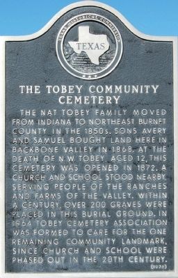
The Tobey Community Cemetery
The Nat Tobey family moved from Indiana to northeast Burnet County in the 1850s. Sons Avery and Samuel bought land here in Backbone Valley in 1868. At the death of N. W. Tobey, aged 12, this cemetery was opened in 1872. A church and school stood nearby, serving people of the ranches and farms of the valley. Within a century, over 200 graves were placed in this burial ground. In 1964 Tobey Cemetery Association was formed to care for the one remaining community landmark, since church and school were phased out in the 20th century.
Erected 1976 by Texas Historical Commission. (Marker Number 9754.)
Topics. This historical marker is listed in this topic list: Cemeteries & Burial Sites. A significant historical year for this entry is 1868.
Location. 30° 38.605′ N, 98° 19.549′ W. Marker is near Marble Falls, Texas, in Burnet County. Marker is at the intersection of CR-123 and Meador Road, on the right when traveling west on CR-123. Touch for map. Marker is in this post office area: Marble Falls TX 78654, United States of America. Touch for directions.
Other nearby markers. At least 8 other markers are within 6 miles of this marker, measured as the crow flies. Crownover Chapel (approx. 2˝ miles away); Longhorn Caverns (approx. 3.2 miles away); Longhorn Cavern Administration Building (approx. 3.2 miles away); Granite Mountain (approx. 3.9 miles away); Marble Falls School Building (approx. 4.8 miles away); Hoover's Valley Cemetery (approx. 5.3 miles away); Fisher - Miller - Grant (approx. 5.4 miles away); St. Frederick Baptist Church (approx. 5.4 miles away). Touch for a list and map of all markers in Marble Falls.
Credits. This page was last revised on November 25, 2020. It was originally submitted on February 20, 2010, by Keith Peterson of Cedar Park, Texas. This page has been viewed 1,006 times since then and 37 times this year. Photos: 1, 2. submitted on February 20, 2010, by Keith Peterson of Cedar Park, Texas. • Bill Pfingsten was the editor who published this page.

