Near Harrisville in Alcona County, Michigan — The American Midwest (Great Lakes)
Alcona County Schools
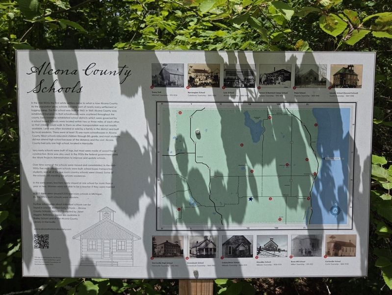
Photographed by Mark Parker, June 24, 2025
1. Alcona County Schools Marker
In the mid-1800s the first white settlers came to what is now Alcona County. As the population grew, schools became part of nearly every settlement or logging camp. The first school was built in 1860. In 1869, Alcona County was established but prior to that schoolhouses were scattered throughout the county. Each township established school districts which were governed by a school board. Schools were located within two or three miles of each other so that children could walk to them as other transportation was not readily available. Land was often donated or sold by a family in the district and built by local residents. There were at least 75 one room schoolhouses in Alcona County. Most schools educated children through 8th grade, and most students did not attend high school because of the distance and the cost. Alcona County had only one high school, located in Harrisville.
Very early schools were built of logs, but most were made of wood frame construction. Brick was also used. In the 1930s the federal government used the Work Projects Administration to improve and update schools.
Over time some of the schools
this page online
In the early years, teachers rarely stayed at one school for more than a year or two. Women were not able to be a teacher if they were married.
In 1931 there were around 5,100 one room schools in Michigan. By the 1950s such schools were obsolete.
Further information about individual schools can be found in a book entitled Early Schools - Alcona County Schools 1860-1957 compiled by Janet Higgins. Reference copies are available in Bailey School and at the Alcona County Library in Harrisville.
www.alconahistoricalsociety.com
This sign is sponsored by the Alona Historical Society funded by a grant from the Community Foundation for Northeast Michigan, 2022
Map key
A. Daisy Dell
Mitchell Township — 1911-1934
B. Norwegian School
Caledonia Township — 1885-1956
C. Low School
Alcona Township — 1880-1905
D. Larson & Rustand Camp School
Hawes Township — 1915-1916
E. Pyne School
Haynes Township — 1901-1945
F. Lincoln School (Second School)
Gustin Township — 1887-1948
G. Harrisville High School
Home Township — 1912-1957
H. Greenbush School
Greenbush Township — 1869-1943
I. Indian/Alvin School
Mikado Township — 1898-1939
J.Klondike School Mikado Township — 1908-1935
K. Bean Hill School
Millen Township — 1911-1951
L. Curtisville School
Curtis Township — 1884-1930
Erected by Alcona Historical Society.
Topics. This historical marker is listed in these topic lists: Education • Settlements & Settlers. A significant historical year for this entry is 1860.
Location. 44° 42.695′ N, 83° 16.345′ W. Marker is near Harrisville, Michigan, in Alcona County. It is on Point Road east of Sturgeon Trailways Road, on the left when traveling east. The marker stands near the parking lot for Sturgeon Point Lighthouse. Touch for map. Marker is at or near this postal address: 6036 Point Road, Harrisville MI 48740, United States of America. Touch for directions.

Regionally, this marker is in Northern Michigan Lower Peninsula and in one of the Lake Huron Shore counties. It is also in the American Midwest. Globally, it is in North America, in the Great North Woods, on the Great Lakes, in the Western Hemisphere, in the Western World, and in the Anglosphere. Historically, it finds itself in what was once the Northwest Territory.
Other nearby markers. At least 8 other markers are within walking distance of this marker: Bailey School (a few steps from this marker); Get Into Your Sanctuary / Thunder Bay National Marine Sanctuary (within shouting distance of this marker); The "Bernice D" (within shouting distance of this marker); a different marker also named Bernice D (about 300 feet away, measured in a direct line); Rudder Unknown (about 400 feet away); Marine City (about 400 feet away); U.S. Coast Guard Watchtower Alarm Bell (about 400 feet away); Rudder "Marine City" (about 400 feet away). Touch for a list and map of all markers in Harrisville.
More about this marker. The marker is near Bailey School at the Sturgeon Point Lighthouse complex. Access is on a short walking trail from the parking lot.
Credits. This page was last revised on July 8, 2025. It was originally submitted on July 4, 2025, by Mark Parker of Hickory, North Carolina. This page has been viewed 284 times since then and 89 times this year. Last updated on July 6, 2025, by Mark Parker of Hickory, North Carolina. Photo 1. submitted on July 5, 2025, by Mark Parker of Hickory, North Carolina. • Devry Becker Jones was the editor who published this page.
Editor’s want-list for this marker. A wide view photo of the marker and the surrounding area together in context. • • Can you help?
