Clay Township in Gallipolis in Gallia County, Ohio — The American Midwest (Great Lakes)
Teens Run Bridge
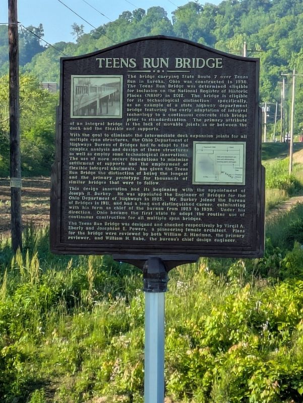
Photographed by Bruce InCharlotte, May 25, 2025
1. Teens Run Bridge Marker
The bridge carrying State Route 7 over Teens Run in Eureka, Ohio was constructed in 1938. The Teens Run Bridge was determined eligible for inclusion on the National Register of Historic Places (NRHP) in 2012. The bridge is eligible for its technical distinction specifically, as an example of a state highway department bridge featuring the early adaptation of integral technology to a continuous concrete slab bridge prior to standardization. The primary attribute of an integral bridge is the lack of movable joints in or between the deck and the flexible end supports.
With the goal to eliminate the intermediate deck expansion joints for all multiple span structures, the Ohio Department of Highways Bureau of Bridges had to adapt to the complex analysis and design of these structures as well as employ some technical innovations. The use of more secure foundations to minimize settlement of supports and the employment of flexible integral abutments, has given the Teens Run Bridge the distinction of being the longest and the primary prototype for thousands of similar bridges that were to follow.
This design innovation has
this page online
The Teens Run Bridge was designed and checked respectively by Virgil A. Eberly and Josephine E. Powers, a pioneering female architect. Plans for the bridge were reviewed by both William S. Hindman, the primary reviewer, and William H. Rebe, the bureau's chief design engineer.
Topics. This historical marker is listed in this topic list: Bridges & Viaducts. A significant historical year for this entry is 1938.
Location. 38° 41.191′ N, 82° 11.534′ W. Marker is in Gallipolis, Ohio, in Gallia County. It is in Clay Township. It is on Ohio 7, on the left when traveling south. Touch for map. Marker is at or near this postal address: 13280 OH-7, Gallipolis OH 45631, United States of America. Touch for directions.

Regionally, this marker is in the American Midwest, in the Ohio River Valley, in Appalachia, and specifically in Northern Appalachia. Globally, it is in North America, the Western Hemisphere, the Western World, and the Anglosphere. Historically, it finds itself in what was once the Viceroyalty of New France, the Haudenosaunee (Iroquois) Confederacy, the territory of the Mississippian Culture, and the Northwest Territory.
Other nearby markers. At least 8 other markers are within 9 miles of this marker, measured as the crow flies: Here Lies James Jeffers (approx. 1.1 miles away); Mercer’s Bottom / Captain John Hereford (approx. 2.8 miles away in West Virginia); May Moore Mound (approx. 3.7 miles away in West Virginia); Thomas Hannan (approx. 7 miles away in West Virginia); Clover Archeological Site (approx. 7½ miles away in West Virginia); Albert Gallatin Jenkins (approx. 7½ miles away in West Virginia); General Jenkins (approx. 7.6 miles away in West Virginia); Gallia County, Gallipolis and the Ohio River (approx. 8.3 miles away). Touch for a list and map of all markers in Gallipolis.
Credits. This page was last revised on August 17, 2025. It was originally submitted on July 13, 2025, by Bruce InCharlotte of Charlotte, North Carolina. This page has been viewed 204 times since then and 68 times this year. Photo 1. submitted on July 13, 2025, by Bruce InCharlotte of Charlotte, North Carolina. • Andrew Ruppenstein was the editor who published this page.
