
City Centre in Kingston upon Hull, England, United Kingdom — Northwestern Europe (the British Isles)
The Story of the Neptune Inn
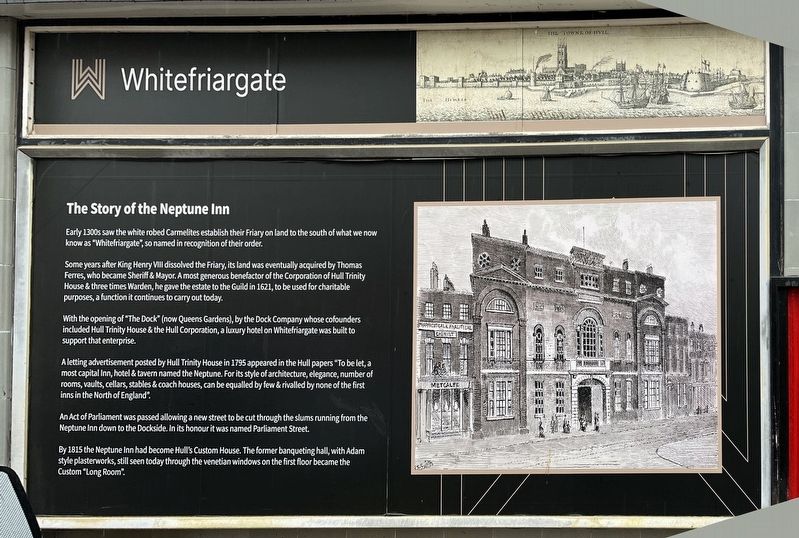
Photographed by Ray Gurganus, April 15, 2025
1. The Story of the Neptune Inn Marker
Some years after King Henry VIII dissolved the Friary, its land was eventually acquired by Thomas Ferres, who became Sheriff & Mayor. A most generous benefactor of the Corporation of Hull Trinity House & three times Warden, he gave the estate to the Guild in 1621, to be used for charitable purposes, a function it continues to carry out today.
With the opening of "The Dock" (now Queens Gardens), by the Dock Company whose cofounders included Hull Trinity House & the Hull Corporation, a luxury hotel on Whitefriargate was built to support that enterprise.
A letting advertisement posted by Hull Trinity House in 1795 appeared in the Hull papers "To be let, a most capital Inn, hotel & tavern named the Neptune. For its style of architecture, elegance, number of rooms, vaults, cellars, stables & coach houses, can be equalled by few & rivalled by none of the first inns in the North of England".
An Act of Parliament was passed allowing a new street to be
this page online
By 1815 the Neptune Inn had become Hull's Custom House. The former banqueting hall, with Adam style plasterworks, still seen today through the venetian windows on the first floor became the Custom "Long Room".
Topics. This historical marker is listed in this topic list: Notable Buildings.
Location. 53° 44.581′ N, 0° 20.138′ W. Marker is in Kingston upon Hull, England. It is in City Centre. It is on Whitefriargate, on the right when traveling east. Touch for map. Marker is at or near this postal address: 55 Whitefriargate, Kingston upon Hull, England HU1 2ER, United Kingdom. Touch for directions.

Regionally, this marker is in England’s Yorkshire & The Humber. Globally, it is on the Atlantic Ocean, in the North Atlantic Region, in Europe, in Atlantic Europe, on one of the British Isles, in the Western World, and in the Anglosphere. Historically, it finds itself in what was once the Roman Empire.
Other nearby markers. At least 7 other markers are within 13 kilometers of this marker, measured as the crow flies: Old Grammar School (about 150 meters away, measured in a direct line); Amy Johnson, 1903-1941 (approx. 0.6 kilometers away); Amy Johnson's Famous Flight, May 1930 (approx. 0.6 kilometers away); Hull General Cemetery (approx. 2.2 kilometers away); The Spring Bank West Quaker Burial Ground (approx. 2.3 kilometers away); Welcome to Beverley (approx. 12.3 kilometers away); Beverley Station History (approx. 12.4 kilometers away).
Credits. This page was last revised on July 14, 2025. It was originally submitted on July 14, 2025, by Ray Gurganus of Washington, District of Columbia. This page has been viewed 169 times since then and 43 times this year. Photo 1. submitted on July 14, 2025, by Ray Gurganus of Washington, District of Columbia. • Andrew Ruppenstein was the editor who published this page.
Editor’s want-list for this marker. photo of the marker within its surroundings • Can you help?
