St. Clair Township near New Florence in Westmoreland County, Pennsylvania — The American Northeast (Mid-Atlantic)
Laurel Hill Iron Furnace
Photographed by Bradley Owen, July 12, 2025
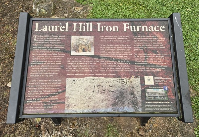
1. Laurel Hill Iron Furnace Marker
The Laurel Hill Iron Furnace was built in 1846 by Hezekiah Reed, Gallagher, and Hale and operated until 1855. Before the Civil War, America's iron industry was characterized by numerous small producers, like the Laurel Hill Iron Furnace, scattered throughout the country. At one time, there were nine iron furnaces in Ligonier Valley. This area had a generous supply of the resources needed to make iron: deposits of iron ore, limestone, oak forests to supply wood for charcoal, and water power. The decline of these local furnaces was caused by the growth of the railroad industry during the Civil War which allowed the centralization of iron production in the "big cities".
The major product of the Laurel Hill Iron Furnace was pig iron which was later converted to products at other locations. But the local furnace also cast hollow and flatware such as pots, pans, kettles, bells, weathervanes, stoves, and horse shoes in various sizes. The ironman who produced them was called a "potter" and carried his molds from furnace to furnace, casting enough items at each site to meet local demand.
To start a furnace, the stack was filled
this page online
To start the blast a water wheel activated the large bellows. The water system used to power these bellows included a 500 foot tunnel connected to a dam on Baldwin Run. As the blast continued, slag (the impurities in the iron ore) and molten iron ran down into the hearth. Slag, separated from the iron by the fluxing action of the limestone, had to be drawn off periodically. Directly in front of the furnace stood the casting house or shed where molten iron flowed into molds, commonly called pigs because of their resemblance to suckling pigs-thus the name "pig iron". The blast furnace was intended to operate day and night with new fuel, iron ore, and limestone added continually to maintain production.
The Laurel Hill Iron Furnace was a boost to the local economy as it employed many people. The operation took 15 to 20 men, working in 12 hour

Photographed by Bradley Owen, July 12, 2025
2. Laurel Hill Iron Furnace and Marker
(Caption):
Below: The top view of the furnace, which is rarely seen, is engraved with the year it was constructed.
Erected by The Pennsylvania Department of Conservation and Natural Resources.
Topics. This historical marker is listed in these topic lists: Industry & Commerce • Natural Resources. A significant historical year for this entry is 1846.
Location. 40° 22.02′ N, 79° 3.556′ W. Marker is near New Florence, Pennsylvania, in Westmoreland County. It is in St. Clair Township. It is on Furnace Lane south of Sugar Run Road, on the left when traveling south. Touch for map. Marker is at or near this postal address: 114 Wyoming Lane, New Florence PA 15944, United States of America. Touch for directions.

Regionally, this marker is in the Laurel Highlands and in Greater Pittsburgh. It is also in the American Northeast, in the Mid-Atlantic, in Appalachia, and specifically in Northern Appalachia. Globally, it is in North America, the Western Hemisphere, the Western

Photographed by Bradley Owen, July 12, 2025
3. Laurel Hill Iron Furnace
Other nearby markers. At least 8 other markers are within 6 miles of this marker, measured as the crow flies: Veterans Memorial (approx. 0.9 miles away); Pennsylvania Keystone Markers (approx. 0.9 miles away); New Florence (approx. 0.9 miles away); a different marker also named New Florence (approx. 1.1 miles away); Seward Area Memorial Park (approx. 3.8 miles away); Seward Veterans Memorial (approx. 3.9 miles away); Robinson War Memorial (approx. 4.8 miles away); Bolivar Veterans Memorial (approx. 5.3 miles away). Touch for a list and map of all markers in New Florence.
Credits. This page was last revised on July 14, 2025. It was originally submitted on July 14, 2025, by Bradley Owen of Morgantown, West Virginia. This page has been viewed 190 times since then and 64 times this year. Photos: 1, 2, 3. submitted on July 14, 2025, by Bradley Owen of Morgantown, West Virginia.
