Grace in Caribou County, Idaho — The American West (Mountains)
History of the Turner Road Penstock Bridge

Photographed by Roger Scot Johns, July 17, 2025
1. History of the Turner Road Penstock Bridge Marker
Approximately two miles west of here, a unique bridge built in the 1920s spanned the 11-foot-diameter flowline which crossed the fertile farmland west of the Grace Dam.
Turner, a small agricultural community located west of the town of Grace, was settled in the late 1890s. Originally known as China Flats, it was renamed Turner in 1900, when a school and post office were established.
The bridge provided a crossing point over the 11-foot-diameter wood-stave flowline which conveys water approximately 4.5 miles between Grace Dam on the Bear River to the Grace Power Plant.
The original bridge was replaced in 2016 by the current structure, which used geosynthetic reinforced soil integrated bridge system (GRS-IBS) technology.
20th Century Technology
The original concrete- and steel-culvert bridge was constructed of two steel arch pipes on concrete and pile foundations. The roadway fill was contained over the arch pipes by concrete wing walls. The bridge spanned two flowlines from the Grace Dam, one of which was removed in the 1980s.
The bridge was considered a unique and efficient design. The arches, specifically
this page online
A New Century and New Technology
The reconstructed bridge represents new technology used for bridges across the United States. GRS-IBS is built by alternating layers of engineered backfill with sheets of geosynthetic reinforcement.
The US. Forest Service first used gravity walls in the 1970s to stabilize logging road embankments. Although GRS has been used in only the last few decades, the concept of reinforcing soil with organic materials has been around for thousands of years, dating back to straw and mud dwellings. GRS-IBS is adaptable to different site conditions and can be used for new or replacement structures with steel or concrete superstructures.
What is a Flowline?
A flowline is a pipe that conveys water from a dam at lower pressure to a point where the pipe slope steepens to raise the water pressure enough to drive turbines in the powerhouse. The steeper section of pipe with higher pressure is called a penstock.
[Image 1 Caption]
Few
Photographed by Roger Scot Johns, July 17, 2025
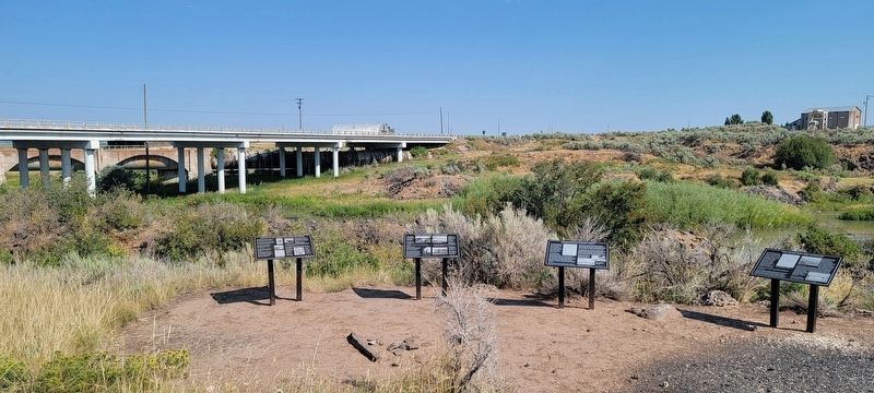
2. The four panels arrayed along the river below the dam.
The subject marker is the leftmost of the four.
[Image 2 Caption]
Construction crew building four-mile long wood and steel flowline (penstock). November 2, 1907. (Image courtesy PacifiCorp).
[Image 3 Caption]
Until 1948, Grace and the surrounding area including Gem, Gentile Valley, and Upper Portneuf were part of Bannock County as shown on this historic map. The residents voted to become part of Caribou County on January 11, 1948. (Map courtesy Metsker's Atlas of Bannock County, Idaho 1948/Historic Map Works).
[Image 4 Caption]
This photo shows the Turner Bridge under construction over the flowline. The bridge abutments were built using GRS-IBS technology. Alternating layers of engineered backfill with sheets of geosynthetic reinforcement. Concrete was used for the bridge deck. (Image courtesy LHTAC).
[Image 5 Caption]
Image courtesy Taylor Planning.
[Credits lower right]
Project created in cooperation with: Lhtac2, ITD, Idaho Historical Society (logos)
Topics. This historical marker is

Photographed by Roger Scot Johns, July 17, 2025
3. The Flowline
Location. 42° 35.15′ N, 111° 43.774′ W. Marker is in Grace, Idaho, in Caribou County. It is at the intersection of N Main St (Idaho Route 34 at milepost 46) and Grace Dam Road, on the right when traveling north on N Main St. 450 feet northeast on Grace Dam Rd at river access parking area. Touch for map. Marker is at or near this postal address: 705 N Main St, Grace ID 83241, United States of America. Touch for directions.

Regionally, this marker is in Bear River Country. It is also in the American Mountain West. Globally, it is in North America, the Western Hemisphere, the Western World, and the Anglosphere.
Other nearby markers. At least 8 other markers are within 5 miles of this marker, measured as the crow flies: Lucius Lucien Nunn - Power Pioneer (here, next to this marker); Last Chance Canal Co. Ltd. (approx. half a mile away); Black Canyon Gorge (approx. 1.3 miles away); Last Chance Canal (approx. 1.4 miles away); Lava Flows and Wagon Trains (approx. 4 miles away); California dreaming in 1841 (approx. 4 miles away); Horatio's Journey (approx. 4½ miles away); Guiding Landmark... (approx. 4½ miles away). Touch for a list and map of all markers in Grace.
More about this marker. There are four plate metal panels in a row, three of historical interest concerning the dam and flowline, and one regarding the native cutthroat trout species of interest to anglers. This is a Class 5 rated whitewater put-in location on the Black Canyon, for expert boaters only.
Credits. This page was last revised on July 29, 2025. It was originally submitted on July 18, 2025, by Roger Scot Johns of Eagle, Idaho. This page has been viewed 191 times since then and 66 times this year. Photos: 1, 2, 3. submitted on July 18, 2025, by Roger Scot Johns of Eagle, Idaho. • Andrew Ruppenstein was the editor who published this page.
