
Helper in Carbon County, Utah — The American Mountains (Southwest)
Historic Helper
From Past to Present
Photographed by Jeremy Snow, June 28, 2025
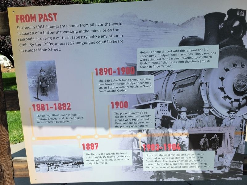
1. Historic Helper Marker, Side One
Settled in 1881, immigrants came from all over the world in search of a better life working in the mines or on the railroads, creating a cultural tapestry unlike any other in Utah. By the 1920s, at least 27 languages could be heard on Helper Main Street.
Helper's name arrived with the railyard and its necessity of "helper" steam engines. These engines were attached to the trains traveling to Northern Utah, "helping" the trains with the steep grades found in Price Canyon.
1881-1882
The Denver Rio Grande Western Railway arrived, and Helper began to establish a population.
1887
The Denver Rio Grande Railroad built roughly 27 frame residences to prompt the establishment of a freight terminal.
1890-1900
The Salt Lake Tribune announced the new town of Helper. Helper became a Union Station with terminals in Grand Junction and Ogden.
1900
The population was 385 people, sixteen nationality groups were represented. Merchant and Laborer were the primary occupations.
1903-1904
Unsuccessful coal mining strikes by Italians resulted in being blacklisted from mines in Castle Gate. The newly unemployed
this page online
1924-1925
The majority of the 157 businesses that formed Helper's commercial district-such as specialty shops, cafes, coffeehouses, saloons, theaters, general mercantile, and various service-oriented businesses-were operated by the town's diverse population of ethnic groups.
1930
The Great Depression hit and the position of Helper along the railroad helped provide some stability.
1960
Coal production increased during World War II and continued to 1960s.
1970-1990
The coal industry experienced highs and lows, especially in the 1990s coal and railroad declined. Because of this drop in the industry Helper also declined in conjunction with those industries but has now maintained a fairly steady population since 2010.
To Present
Helper continues to grow in popularity as tourists pass through each year. The Helper of today is built upon its rich history, world class recreation opportunities, charming downtown, and artistic culture. While you are here, make sure to visit all of our Helper Highlights and enjoy our Featured

Photographed by Jeremy Snow, June 28, 2025
2. Historic Helper Marker, Side Two
Downtown Helper
Visit Helper's Historic downtown, its Main Street boasts beautifully preserved buildings converted into restaurants, art galleries and more.
Balance Rock
Look to the north of Main Street to see this geological feature as it stands out among the mountains.
Big John
This iconic statue made of black fiberglass, stands over 20 feet tall and commemorates the roots of this historical coal mining community.
The Helper Museum
Housed in the old Hotel Helper, exhibits showcase everything from artifacts of coal camp life to a collection of photographs by the famous documentary photographer Dorothea Lange.
[various community activities throughout the year not transcribed]
Topics. This historical marker is listed in these topic lists: Industry & Commerce • Settlements & Settlers. A significant historical year for this entry is 1881.
Location. 39° 40.979′ N, 110° 51.349′ W. Marker is in Helper, Utah, in Carbon County. It is on South 100 West, on the right when traveling south. Three panels in a row ;ocated to the north of the enterance to the Helper Mining Display underneath a small cover. Touch for map. Marker is at or near this postal address: 252 S 100 W, Helper UT 84526, United States of America. Touch for directions.

Regionally, this marker is in Canyon Country. It is also in the American Mountain West, on the Colorado Plateau, and at the Four Corners. Globally, it is in North America, the Western Hemisphere, the Western World, and the Anglosphere. Historically, it finds itself in what was once New Spain and also Mexico’s Alta California.

Other nearby markers. At least 8 other markers are within walking distance of this marker: Geneva Coal Mine (here, next to this marker); The Four Steps Necessary For Mining Coal (a few steps from this marker); The Mucking Machine (a few steps from this marker); Sullivan Shortwall Machine (a few steps from this marker); Continous Miner Section (a few steps from this marker); Conventional Mining Section (within shouting distance of this marker); Joy Loading Machine (within shouting distance of this marker); Coal Mines of Carbon County Utah (within shouting distance of this marker). Touch for a list and map of all markers in Helper.
Credits. This page was last revised on July 22, 2025. It was originally submitted on July 18, 2025, by Jeremy Snow of Cedar City, Utah. This page has been viewed 132 times since then and 38 times this year. Photos: 1, 2. submitted on July 18, 2025, by Jeremy Snow of Cedar City, Utah. • Andrew Ruppenstein was the editor who published this page.
