Pierre in Hughes County, South Dakota — The American Midwest (Upper Plains)
The Lewis and Clark Expedition
| — | National Park Service, U.S. Department of the Interior | — |
Photographed by Ruth VanSteenwyk, July 18, 2017
1. The Lewis and Clark Expedition Marker
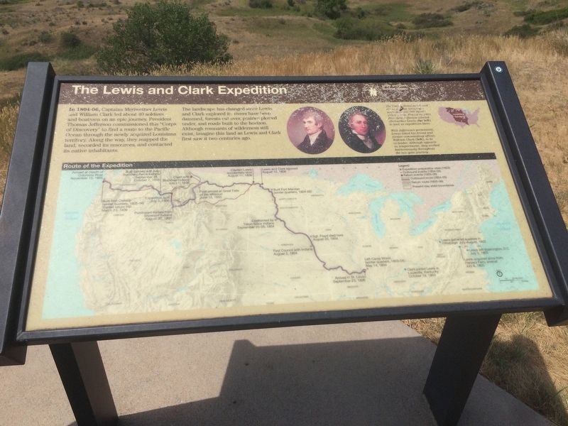
In 1804-06, Captains Meriwether Lewis and William Clark lead about 40 soldiers and boatmen on an epic journey. President Thomas Jefferson commissioned this "Corps of Discovery" to find a rout to the Pacific Ocean through the newly acquired Louisiana Territory. Along the way, they mapped the land, recorded its resources, and contacted its native inhabitants.
The landscape has changed since Lewis and Clark explored it; rivers have been dammed, forests cut over, prairies plowed under, and roads built to the horizon. Although remnants of wilderness still exist, imagine this land as Lewis and Clark first saw it two centuries ago.
The United States purchased the Louisiana territory - more than 350,000 square miles - from Fence in 1803. President Jefferson selected Meriwether Lewis (far Left) to lead an expedition there.
With Jefferson's permission, Lewis asked his friend and former commanding officer, William Clark (left), to be co-leader. Although opposite in temperament, they worked harmoniously throughout the two-year journey.
Erected by National Park Service, U.S. Department of the Interior.
Topics and series.
this page online
Location. 44° 26.64′ N, 100° 22.547′ W. Marker is in Pierre, South Dakota, in Hughes County. It is on State Highway 1804 1.7 miles west of Grey Goose Rd. Touch for map. Marker is at or near this postal address: 20271 State Highway 1804, Pierre SD 57501, United States of America. Touch for directions.

Regionally, this marker is in East River. It is also in the American Lewis & Clark Corridor, on the prairies, and on the Northern Plains. Globally, it is in North America, the Western Hemisphere, the Western World, and the Anglosphere. Historically, it finds itself in what was once Rupert’s Land and also the Louisiana Purchase.
Other nearby markers. At least 8 other markers are within walking distance of this marker: A Changing Landscape (here, next to this marker); A Tense Three Days (here, next to this marker); The Lewis & Clark Expedition (here, next to this marker); The Oahe Dam & Lake
Photographed by Ruth VanSteenwyk, July 18, 2017
2. The Lewis and Clark Expedition Marker
Credits. This page was last revised on July 25, 2025. It was originally submitted on January 17, 2018, by Ruth VanSteenwyk of Aberdeen, South Dakota. This page has been viewed 375 times since then and 27 times this year. Last updated on July 22, 2025, by Mark Parker of Hickory, North Carolina. Photos: 1, 2. submitted on January 17, 2018, by Ruth VanSteenwyk of Aberdeen, South Dakota. • Devry Becker Jones was the editor who published this page.
