Newark in Licking County, Ohio — The American Midwest (Great Lakes)
The Interstate Highway System
Photographed by Craig Doda, September 2, 2022
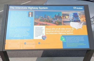
1. Interstate Highway System Marker
Howard Laferie never imagined that the rumble of diesel engines would be a common part of his life when he graduated with a degree in architectural engineering in 1825. Even so, trucking and transportation became a primary focus of care. Thanks a series at career changes after the banking crisis of 1932, Howard found himself in charge of a trucking company that delivered for A&P grocery stores. He founded Bocor Freight in 1946, which is today Truck One: Just ten years after the formation of DGL. President Eisenhower signed the Federal Aid Highway Act of 1956, which established the interstate Highway System.
Interstate 10, which is 2,131 miles long and connects Maryland to Utah, passes directly through Licking County The establishment of the interstate Highway System and its course through Licking County dramatically improved Me LeFev's ability no grow BGL Motor Freight and establish Newark as a center of the trucking Industry.
1946
Howard Laferie founded B&L Freight.
1956
Interstate Highway System established.
Interstate 70 closely follows the path of the National Road, US Route 40. The path it follows builds
this page online
Wow!
About 25% of all miles driven by American drivers are on part of the Interstate Highway System.
What will the future of transportation look like? The development of space exploration and the establishment of private spaceflight companies might mean that one day it could be common to travel beyond Earth's atmosphere.
Check out our SiDome to get a sneak peek at what lies beyond our planet and imagine yourself exploring our Solar System!
Erected by The Works R Ohio Center for History, Arts & Technology.
Topics. This historical marker is listed in this topic list: Railroads & Streetcars. A significant historical year for this entry is 1825.
Location. 40° 3.428′ N, 82° 23.95′ W. Marker is in Newark, Ohio, in Licking County. It is on South 1st Street, on the left when traveling north. Touch for map. Marker is at or near this postal address: 51 S 1st St, Newark OH 43055, United States of America. Touch for directions.

Regionally, this marker is in the Columbus Metropolitan Area. It is also in the American Midwest, in the Corn Belt, in Appalachia,
Photographed by Craig Doda, September 2, 2022
2. Interstate Highway System Marker
Other nearby markers. At least 8 other markers are within walking distance of this marker: Railroads (a few steps from this marker); The Interurban Railway (a few steps from this marker); Ohio & Erie Canal (within shouting distance of this marker); In loving memory of Herbert A. Odle (within shouting distance of this marker); Newark Native Jerryie Mock (within shouting distance of this marker); The National Road (within shouting distance of this marker); Footpaths & Waterways (within shouting distance of this marker); Welcome to the Streetscape & History Walk (within shouting distance of this marker). Touch for a list and map of all markers in Newark.
Credits. This page was last revised on July 29, 2025. It was originally submitted on September 12, 2022, by Craig Doda of Napoleon, Ohio. This page has been viewed 291 times since then and 32 times this year. Last updated on July 28, 2025, by Raquel Mack of Oberlin, Ohio. Photos: 1, 2. submitted on September 12, 2022, by Craig Doda of Napoleon, Ohio. • Devry Becker Jones was the editor who published this page.
