Oswego in Oswego County, New York — The American Northeast (Mid-Atlantic)
Earthworks and Officer's Row at Fort Ontario

Photographed by Steve Stoessel, July 23, 2025
1. Earthworks and Officer's Row at Fort Ontario Marker
Earthworks 1759-1902
All four versions of Fort Ontario built from 1755 to 1839 were surrounded by a ditch (dry moat) and earthworks constructed of a dirt and timber facing material called revetment designed to provide a protective barrier between the garrison and any attackers. Attackers would have to endure withering musket and artillery fire from the fort while ascending a long sloping hill (glacis) before reaching the ditch. Once in the ditch, they would be caught in a concentrated crossfire of muskets, artillery, and grenades.
Outer Earthworks 1755-1815
Small fortifications such as redoubts. ravelins, redans, and other defensive works were located beyond the main fort and earthworks. An enemy would have to capture these smaller defenses before assaulting the main fortification Picket or guard posts were pl located even further out to warn of an approaching enemy and provide defense for patrols, hunting, and woodcutting parties.
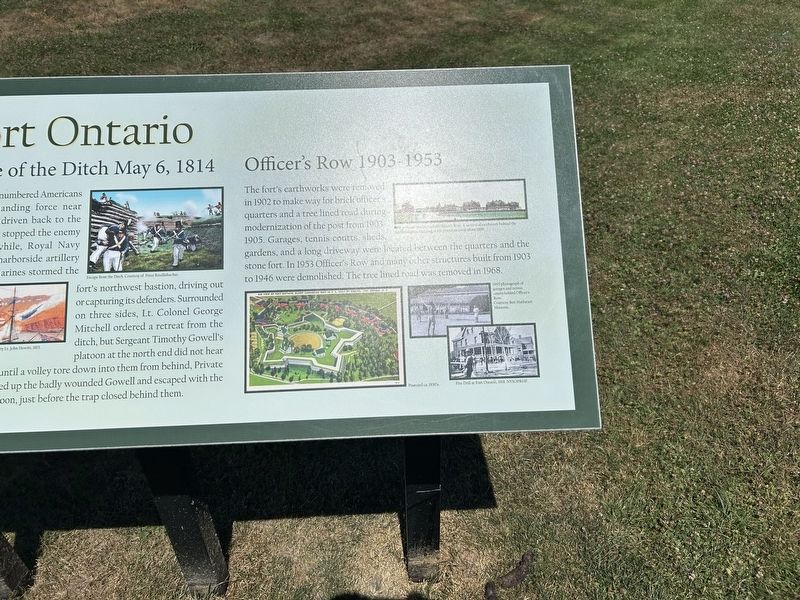
Defense of the Ditch May 6, 1814
Around noon outnumbered Americans met a British landing force near shore, but were driven back to the ditch where they stopped the enemy advance. Meanwhile,
this page online
Officer's Row 1903-1953
The fort's earthworks were removed in 1902 to make way for brick officer's quarters and a tree lined road during modernization of the post from 1903-1905. Garages, tennis courts, sheds, gardens, and a long driveway were located between the quarters and the stone fort. In 1953, Officer's Row and many other structures built from 1903 to 1946 were demolished. The tree lined road was removed in 1968
[Photo and Illustration Captions, ccw from top left: ]
- Detail of map by Thomas Sowers, 1760. Courtesy of the British Library.
- 1761 Perspective View of Fort Ontario by Francis Phister Courtesy of the British Library
- C. 1900 Photograph of the ditch taken from about this location.
- Photograph of the ditch and timber revetment by Bastion C.
- Detail of engraving Attack on Fort Oswego hy Lt. John Hewitt, 1815.
Courtesy Library & Archives of Canada.
- Postcard ca. 1930s
- Fire Drill at Fort Ontario 1918
- 1943 photograph of garage and tennis courts behind Officers Row.
- 1908 postcard photograph of Officer’s Row. A section of earthworks behind the Administration Building at left remained until about 1908.
- Escape from the Ditch. Courtesy of Peter Rindlisbacher.
Topics.

Photographed by Steve Stoessel, July 23, 2025
2. Left Side of Marker
Location. 43° 27.96′ N, 76° 30.406′ W. Marker is in Oswego, New York, in Oswego County. It is on Fort Ontario Road 0.1 miles north of Barbara Donahue Drive, on the left when traveling north. Located between the parking areas at Fort Ontario. Touch for map. Marker is in this post office area: Oswego NY 13126, United States of America. Touch for directions.

Regionally, this marker is in Upstate New York, specifically in Central New York, and in the Syracuse Metropolitan Area. It is also in the American Northeast and in the Mid-Atlantic. Globally, it is in North America, on the Great Lakes, in the Western Hemisphere, in the Western World, and in the Anglosphere. Historically, it finds itself in what was once New Netherland and also one of the original Thirteen Colonies.
Other nearby markers. At least 8 other markers are within walking distance of this marker: African Troops at Fort Ontario (about 400 feet away, measured in a direct line); Fort Ontario (about 500 feet
Photographed by Steve Stoessel, July 23, 2025
3. Right Side of marker
More about this marker. This is a large marker almost eight feet long.
Also see . . . Fort Ontario. (Submitted on August 9, 2025, by Steve Stoessel of Niskayuna, New York.)

Photographed by Steve Stoessel, July 23, 2025
4. Earthworks and Officer's Row at Fort Ontario Marker
Credits. This page was last revised on August 9, 2025. It was originally submitted on August 9, 2025, by Steve Stoessel of Niskayuna, New York. This page has been viewed 137 times since then and 37 times this year. Photos: 1, 2, 3, 4. submitted on August 9, 2025, by Steve Stoessel of Niskayuna, New York.
