Manassa in Conejos County, Colorado — The American Mountains (Southwest)
Morman Pioneers
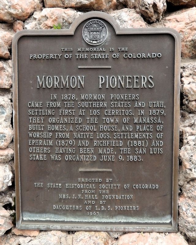
Photographed by Cosmos Mariner, July 12, 2025
1. Morman Pioneers Marker
In 1878, Mormon pioneers came from the southern states and Utah, settling first at Los Cerritos. In 1879, they organized the town of Manassa, built homes, a school house, and place of worship from native logs. Settlements of Ephraim (1879) and Richfield (1881) and others having been made, the San Luis Stake was organized June 9, 1883.
———
This memorial is the property of the State of Colorado
———
Erected by the State Historical Society of Colorado
from the Mrs. J. N. Hall Foundation
and by Daughters of L.D.S. Pioneers
1963
Erected 1963 by State Historical Society of Colorado and Daughters of L.D.S. Pioneers.
Topics and series. This historical marker is listed in these topic lists: Religion & Religious Structures • Settlements & Settlers. In addition, it is included in the History Colorado series list. A significant historical year for this entry is 1879.
Location. 37° 10.447′ N, 105° 56.076′ W. Marker is in Manassa, Colorado, in Conejos County. It is on Main Street (State Highway 142) just east of North 4th Street, on the left when traveling east. The marker is located on the west side of the Church of Jesus Christ of
this page online

Regionally, this marker is in the San Juan Mountains and in the San Luis Valley. It is also in the American Mountain West. Globally, it is in North America, the Rocky Mountains, the Western Hemisphere, the Western World, and the Anglosphere. Historically, it finds itself in what was once New Spain and also the Republic of Texas.
Other nearby markers. At least 8 other markers are within 8 miles of this marker, measured as the crow flies: "The Manassa Mauler" (about 400 feet away, measured in a direct line); The First Bed and Breakfasts (about 500 feet away); The La Jara Consolidated School (approx. 7.1 miles away); Howsam Park (approx. 7.2 miles away); Our Lady of Guadalupe Church (approx. 7.6 miles away); Fred "Lightning Heart" Haberlein (approx. 7.8 miles away); S.P.M.D.T.U. Concilio Superior (approx. 7.9 miles away); Don Celedonio Mondragón (approx. 7.9 miles away). Touch for a list and map of all markers in Manassa.
Also see . . .
1. Manassa, Colorado (Amateur Mormon Historian).

Photographed by Cosmos Mariner, July 12, 2025
2. Morman Pioneers Marker
Looking north from Main Street.
Excerpt: Another city to which LDS converts from Tennessee (and the rest of the South) were directed to gather was Manassa, Colorado. Saints came to escape persecution in the south but found the climate cold and harsh. Saints like the Talley and Depriest families of Lewis County found their way here, along with many others. The Manassa Stake was formed in 1883.(Submitted on August 14, 2025, by Cosmos Mariner of Cape Canaveral, Florida.)So successful was Manassa that additional colonies were set up nearby including Sanford and Morgan (named after John Morgan, the Southern States Mission President at the time). Today Manassa has three wards and a population of over 1,000 within the city limits. About half of the town is Mormon, most of the rest is Hispanic Catholic.
2. Manassa, Colorado (Wikipedia).
Excerpt: People from northern New Mexico settled the area around Manassa in the mid 19th century. Many early settlers were the descendants of colonists from the Spanish colonial period beginning in 1598 with Juan de Oñate's colonization of New Mexico. Today, approximately half of Manassa's residents are of Spanish and Mexican(Submitted on August 14, 2025, by Cosmos Mariner of Cape Canaveral, Florida.)heritage. Most of the other citizens of Manassa are the descendants of the Mormon pioneers who founded Manassa in 1879, and named the town after Manasseh, a son of the Israelite Joseph. Manassa was located a short distance from two ranches purchased by the Mormons from Hispanos on the south side of the Conejos River, across from Los Cerritos, Colorado.Photographed by Cosmos Mariner, July 12, 20253. San Luis Stake Office (1913)Located near the marker, on the north side of the Church of Jesus Christ of Latter-day Saints grounds.The selection of the land for the colony was made on the assurance that the railroad would soon be built nearby. However, one year later the railroad bypassed the colony, and instead passed through Romeo, Colorado, just three miles to the west.

Credits. This page was last revised on August 14, 2025. It was originally submitted on August 13, 2025, by Cosmos Mariner of Cape Canaveral, Florida. This page has been viewed 132 times since then and 32 times this year. Photos: 1. submitted on August 13, 2025, by Cosmos Mariner of Cape Canaveral, Florida. 2, 3. submitted on August 14, 2025, by Cosmos Mariner of Cape Canaveral, Florida.
