Georgetown in Clear Creek County, Colorado — The American Mountains (Southwest)
The Georgetown Loop
Georgetown Loop Mining & RR Park
Photographed by Sandra Hughes Tidwell, August 3, 2025
1. The Georgetown Loop Marker
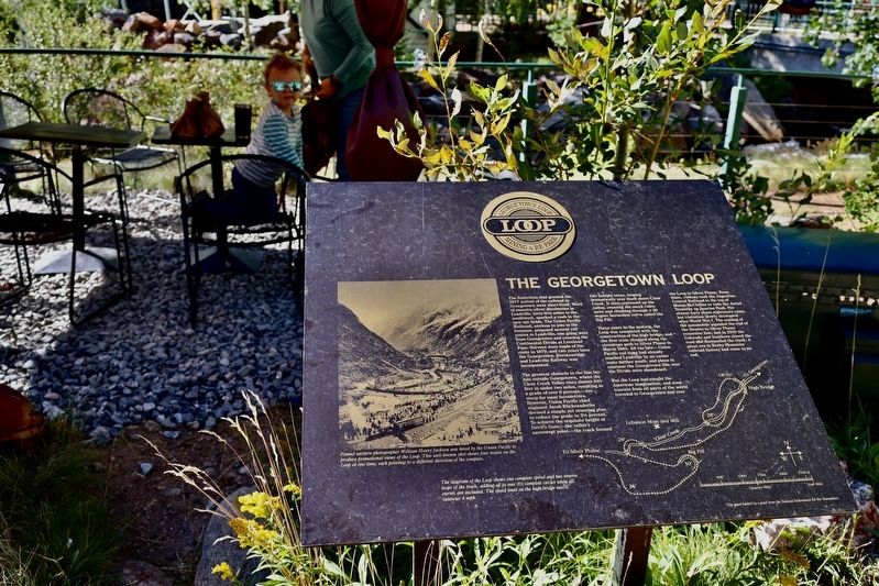
The greatest obstacle to the line lay just outside Georgetown, where the Clear Creek Valley rises almost 640 feet in under two miles, resulting in a grade of over 6 percent-too steep for most locomotives. However, Union Pacific Chief Engineer Jacob Blickensderfer devised a simple yet stunning plan to reduce the grade to 3 1/2 percent.
To achieve the requisite height at Devil's Gate, the valley's narrowest point, the track formed two hairpin turns, looping dramatically over itself above Clear Creek. It then continued up the valley, crossing the creek twice more and climbing through a 30-degree
this page online
Three years in the making, the Loop was completed with the construction of the high bridge, and the first train chugged along the circuitous path to Silver Plume in March 1884. All too late - Union Pacific rail lines had already reached Leadville by an easier route farther south, and plans to continue the Georgetown line over the Divide were abandoned.
But the Loop had caught the American imagination, and soon tourists from all parts of the world traveled to Georgetown and over the Loop to Silver Plume. From there, visitors took the Argentine Central Railroad to the top of Mount McClellan or rode the Aerial Tramway up Sunrise Peak. For about forty years, sightseers came, but visitation slowly decreased after World War I. The coming of the automobile signaled the end of the Denver to Silver Plume excursion line, and in 1939, the Colorado and Southern closed the road and dismantled the track. A great era in Rocky Mountain railroad history had come to an end.
Captions:
Famed western photographer William Henry Johnson was hired by the Union Pacific to produce promotional Views of the Loop. This well-known shot shows four trains on the Loop at one time, each pointing in a different direction of the compass.
Caption:
The diagram of the Loop shows one complete spiral and two reverse loops of the track, adding up to 3 1/2 complete circles when all curves are included. The speed limit on the high bridge was a cautious 4 mph.
Topics. This historical marker is listed in this topic list: Railroads & Streetcars. A significant historical month for this entry is March 1884.
Location. 39° 42.058′ N, 105° 42.402′ W. Marker is in Georgetown, Colorado, in Clear Creek County. It is on Loop Drive. Touch for map. Marker is at or near this postal address: 646 Loop Drive, Georgetown CO 80444, United States of America. Touch for directions.

Regionally, this marker is in the Colorado High Rockies and on the Continental Divide. It is also in the American Mountain West. Globally, it is in North America, the Rocky Mountains, the Western Hemisphere, the Western World, and the Anglosphere.
Other nearby markers. At least 8 other markers are within walking distance of this marker: The Park (a few steps from this marker); Georgetown Loop Project (within shouting distance of this marker); Hamill House Museum (approx. half a mile away); Cornish House, 1892 (approx. half a mile away); Teal Building, 1875 (approx. 0.6 miles away); Old Town Jail (approx. 0.6 miles away); Old County Courthouse, 1868 (approx. 0.6 miles away); Commemorating the Historical Importance of the Georgetown Mining Region (approx. 0.6 miles away). Touch for a list and map of all markers in Georgetown.
Credits. This page was last revised on August 27, 2025. It was originally submitted on August 25, 2025, by Sandra Hughes Tidwell of Killen, Alabama, USA. This page has been viewed 175 times since then and 71 times this year. Photo 1. submitted on August 25, 2025, by Sandra Hughes Tidwell of Killen, Alabama, USA. • Andrew Ruppenstein was the editor who published this page.
