Williston in McKenzie County, North Dakota — The American Midwest (Upper Plains)
Lewis & Clark Wildlife Management Area
Sunday, April 21, 1805
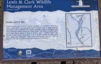
Photographed by Barry Swackhamer, July 24, 2025
1. Lewis & Clark Wildlife Management Area Marker
Erected by North Dakota Game & Fish Management, US Army Corps of Engineers.
Topics and series. This historical marker is listed in this topic list: Exploration. In addition, it is included in the Lewis & Clark Expedition series list.
Location. 48° 6.486′ N, 103° 42.839′ W. Marker is in Williston, North Dakota, in McKenzie County. It can be reached from Theodore Roosevelt Expressway (U.S. 85) near 46th Street North West, on the right when traveling north. The marker is located at the Lewis and Clark Bridge Boating Access on the right just
this page online

Regionally, this marker is in the Bakken Oil Patch. It is also in the American Lewis & Clark Corridor, on the prairies, and on the Northern Plains. Globally, it is in North America, the Western Hemisphere, the Western World, and the Anglosphere. Historically, it finds itself in what was once Rupert’s Land and also the Louisiana Purchase.
Other nearby markers. At least 5 other markers are within 8 miles of this marker, measured as the crow flies: James Memorial Preservation Society (approx. 5.1 miles away); Williston High School (approx. 5.1 miles away); The Old Red Brick Williams County Courthouse (approx. 5.1 miles away); Cut Bluff (approx. 7.1 miles away); Navigating Cut Bluff (approx. 7.1 miles away).
Credits. This page was last revised on August 29, 2025. It was originally submitted on August 28, 2025, by Barry Swackhamer of Brentwood, California. This page has been viewed 104 times since then and 30 times this year. Photo 1. submitted on August 28, 2025, by Barry Swackhamer of Brentwood, California.
