Downtown Owatonna in Steele County, Minnesota — The American Midwest (Upper Plains)
Steele County Courthouse
Photographed by Richard Hawkins, August 29, 2025
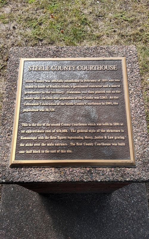
1. Steele County Courthouse Marker
Steele County was officially established in February of 1855 and was named in honor of Franklin Steele, a government contractor and a man of prominence in the territory, Owatonna was then platted out as the County In 1860, the population of the County was 2,863. At the Centennial Celebration of the Steele County Courthouse in 1991, the population was 30,729.
This is the site of the second County Courthouse which was built in 1891 at an approximate cost of $50,000. The general style of the structure is Romanesque with the three figures representing Mercy, Justice & Law gracing the niche over the main entrance. The first County Courthouse was built one-half block to the east of this site.
Topics. This historical marker is listed in this topic list: Notable Buildings. A significant historical month for this entry is February 1855.
Location. 44° 5.011′ N, 93° 13.533′ W. Marker is in Owatonna, Minnesota, in Steele County. It is in Downtown Owatonna. It is on East Main Street. Touch for map. Marker is at or near this postal address: 111 E Main St, Owatonna MN 55060, United States of America. Touch for directions.

Regionally, this marker is in Southeast Minnesota. It is also in the American Midwest and in the Corn Belt. Globally, it is in North America, the Western Hemisphere, the Western World, and the Anglosphere. Historically, it finds itself in what was once Rupert’s Land and also the territory of the Mississippian Culture.
Other nearby markers. At least 8 other markers are within walking distance of this marker: Steele County Veterans (within shouting distance of this marker); National Farmer's Bank of Owatonna (about 400 feet away, measured in a direct line); Rock Island Railway Station 1901 (approx. 0.4 miles away); State Schoolers U.S. Military Memorial (approx. ¾ mile away); Minnesota State Public School for Dependent and Neglected Children
this page online

Photographed by Richard Hawkins, August 29, 2025
2. Steele County Courthouse Marker

Photographed by Richard Hawkins, August 29, 2025
3. "Book of Golden Deeds" at the Steele County Courthouse
Credits. This page was last revised on September 23, 2025. It was originally submitted on August 29, 2025, by Richard Hawkins of Phelan, California. This page has been viewed 42 times since then and 17 times this year. Photos: 1, 2, 3. submitted on August 29, 2025, by Richard Hawkins of Phelan, California. • J. Makali Bruton was the editor who published this page.
