
Niagara Falls in Niagara Region, Ontario — Central Canada (North America)
Stamford Cottage
![Stamford Cottage [on south side of stone cairn] image. Click for full size.](Photos8/893/Photo893699.jpg?830202562900PM "Stamford Cottage [on south side of stone cairn]. Click for full size.")
Photographed by Kevin Westell
1. Stamford Cottage [on south side of stone cairn]
200 yds [N or S] east of this point stood Stamford Cottage, the home of Sir Peregrine Maitland
Lieut-Governor [of] Upper Canada. Property [was] purchased 182[2]. Gov. Maitland retired 1828.
Erected 1934 by Lundy's Lane Historical Society.
Topics. This historical marker is listed in this topic list: Government & Politics. A significant historical year for this entry is 1822.
Location. 43° 8.308′ N, 79° 6.09′ W. Marker is in Niagara Falls, Ontario, in Niagara Region. It is at the intersection of St Paul Ave and Pinestone Rd, on the right when traveling south on St Paul Ave. The plaque is affixed to the south side of the cairn. Touch for map. Marker is at or near this postal address: 2334 St Paul Ave, Niagara Falls ON L2J 0C7, Canada. Touch for directions.

Regionally, this marker is on Ontario’s Golden Horseshoe and in Niagara Canada. It is also in Central Canada. Globally, it is in North America, on the Great Lakes, in the Western Hemisphere, in the Western World, and in the Anglosphere. Historically, it finds itself in what was once a British colony, the Viceroyalty of New France, the Haudenosaunee
this page online
Other nearby markers. At least 8 other markers are within walking distance of this marker: Indian Ossuary (here, next to this marker); a different marker also named Indian Ossuary (a few steps from this marker); a different marker also named Stamford Cottage (a few steps from this marker); Ontario Hydro Memorial (approx. 0.6 kilometers away); Haulage Road Recreational Trail (approx. 0.9 kilometers away); Oswald Regency Cottage circa 1835 (approx. one kilometer away); Stamford Presbyterian Cemetery History (approx. 1.2 kilometers away); 1784 In Memorium 1984 (approx. 1.2 kilometers away). Touch for a list and map of all markers in Niagara Falls.
More about this marker. This 1934 stone cairn bears two unrelated plaques:
- THIS HMDB entry 283045 describes the 1934 Stamford Cottage plaque (south side of cairn).
- HMDB entry 282809 describes the 1934 Indian Ossuary plaque (north side of cairn).
Adjacent is a recent black-and-white sign that re-words these two 1934 plaques (one on each side):
- HMDB entry 75853 describes the Indian Ossuary part of the recent sign.
- HMDB entry 75856 describes
Photographed by Dale K. Benington, June 10, 2012
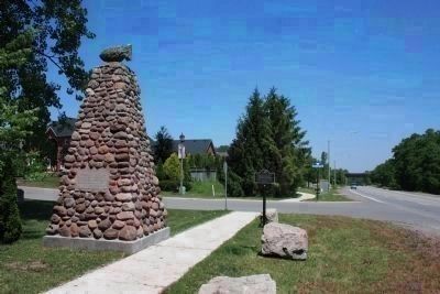
2. Marker in context
Photo faces north. St. Paul Ave is on the right; the cross-street is Pinestone Rd. The 4-metre cairn is topped with a decorative arrow-head (resembling a decorative plump fish). Visible is the adjacent black-and-white plaque, that re-words the two 1934 plaques on the cairn. The rail overpass (distant right) is for the CNR main line from Hamilton to Niagara Falls.
Some history on the plaques: https://ontarioplaques.ca/Plaques/Plaque_Niagara22
Regarding Stamford Cottage. 1. From another plaque, erected over the stone plaque in the 1960s, but removed around 1988:
In this vicinity was Stamford Park, the 172 ha country estate of Sir Peregrine Maitland, Lieutenant-Governor of Upper Canada, 1818-1828. He was a son in law of the Duke of Richmond and a veteran of the Napoleonic Wars. "Stamford Cottage" was begun about 1822 and when completed occupied twenty two rooms "luxuriously furnished". Maitland preferred to live in the quiet atmosphere of this regency style residence rather than at York, Upper Canada's capital. During his stay at "Stamford Park", Maitland contributed to the building of nearby St. John's Anglican Church. In 1828 be became Lieutenant-Governor of Nova Scotia. The estate was sold in 1833. ( from https://ontarioplaques.ca/Plaques/Plaque_Niagara22 )
2. A photo from 1934 shows this stone cairn's unveiling. (https://nfpl.historicniagara.ca/s/images/item/397315)
3. This cairn may or may not have been re-located a short distance, as Niagara Falls expanded. Comparing the 1934 and 2012 photos, these are all similar: the alignment; the distance from the centre of the road; and the distance to the rail overpass.
Also see . . . 1934 photo of the cairn's unveiling. (Submitted on September 3, 2025, by Kevin Westell of St. Catharines, Ontario.)
Credits. This page was last revised on December 21, 2025. It was originally submitted on August 30, 2025, by Kevin Westell of St. Catharines, Ontario. This page has been viewed 48 times since then and 24 times this year. Photos: 1, 2. submitted on August 30, 2025, by Kevin Westell of St. Catharines, Ontario. • Devry Becker Jones was the editor who published this page.
