Welland in Niagara Region, Ontario — Central Canada (North America)
Electric Park
⎯⎯⎯
Stop 19 on the NS&T

Photographed by Tim Boyd, November 18, 2024
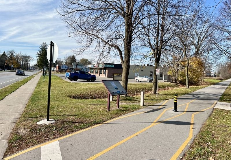
1. Electric Park/ Stop 19 on the NS&T Marker

The NS&T expanded their system and in 1906 began construction of a new line running from Thorold to Port Colborne. By October of 1908, the rails had crossed a new trestle over the Welland River to a station just south of the river. The line was completed to Port Colborne in 1911. In the first photo, undated, a northbound NS&T car is shown crossing the Welland River Trestle.
The NS&T, like most interurban systems originally operated as numbered stops. Near this location was Stop 19. Based on a government order, all stops had to be named. This stop was renamed Electric Park although there was no park at the site.
In the second photo, NS&T cars 620 (in the green) and 82 (in the red) meet at Electric Park. Car 620 is running as a special. This was one of the normal meeting locations between north and southbound
this page online
Interurban passenger service was particularly important at that time because most people did not have automobiles and relied on the railways to travel. Even in 1938, there were 18 trains in each direction on most days providing convenient connections to other communities. Passenger service continued on this line until March 29, 1959. This line was the last interurban passenger service in Canada.
Freight was interchanged in Welland with the Toronto, Hamilton and Buffalo Railway and the Michigan Central. Freight operations to Welland continued using diesel locomotives for a number of years after the electric overhead was removed in 1960.
This display honours the over 50 years of service by the NS&T to the community of Welland.
Le NS&T avait décidé d'elargir et en 1906 commença la construction
Photographed by Tim Boyd, November 18, 2024
2. Electric Park/ Stop 19 on the NS&T Marker
Le NS&T, comme la plupart des systèmes interurbains de l'époque avait initialement numéroté tous les arrêts. À proximité de cet emplacement, on peut trouver Stop 19. Suite à une directive émise par le gouvernement, tous les arrêts numérotés devaient avoir un nom. Cet arrêt a été rebaptisé Electric Park mais il n'y avait pas de parc sur le site.
Le service interurbain était particulièrement important à cette époque parce que la plupart des personnes ne possédaient pas de voitures et comptaient sur le chemin de fer pour voyager. En 1938, 18 trains faisaient déjà presque quotidiennement la navette dans les deux directions offrant des correspondances pratiques vers d'autres communautés.
Le point de correspondance vers de nouvelles destinations pour le fret était Welland, avec le chemin de fer de Toronto, Hamilton et Buffalo et le Michigan Central.
La première photo montre le wagon 620 se dirigeant 82 vers le

courtesy Andy Panko
3. Electric Park/ Stop 19 on the NS&T marker photo detail
A northbound NS&T car shown crossing the Welland River Trestle
Le service de passagers a continué sur cette ligne jusqu'au 29 mars 1959. C'était le dernier service interurbain de passagers au Canada. Le transport de fret, lui, a continué pour un certain nombre d'années avec des locomotives diesel.
Cette exposition honore le service de plus de 50 ans offert par le NS&T à la communauté de Welland.
Erected by Niagara Division of the Canadian Railroad Historical Association.
Topics and series. This historical marker is listed in these topic lists: Industry & Commerce • Railroads & Streetcars. In addition, it is included in the The Welland Canals series list. A significant historical year for this entry is 1899.
Location. 43° 0.231′ N, 79° 16.302′ W. Marker is in Welland, Ontario, in Niagara Region. It is on Thorold Road 0.1 kilometers west of Rice Road, on the right when traveling west. The marker is on the Steve Bauer Trail, just north of Thorold Road. Touch for map. Marker is at or near this postal address: 328 Thorold Rd, Welland ON L3C 6H5,

courtesy Andy Panko
4. Electric Park/ Stop 19 on the NS&T marker photo detail
NS&T cars 620 (in the green) and 82 (in the red) meet at Electric Park

Regionally, this marker is on Ontario’s Golden Horseshoe and in Niagara Canada. It is also in Central Canada. Globally, it is in North America, on the Great Lakes, in the Western Hemisphere, in the Western World, and in the Anglosphere. Historically, it finds itself in what was once a British colony, the Viceroyalty of New France, the Haudenosaunee (Iroquois) Confederacy, and Rupert’s Land.
Other nearby markers. At least 8 other markers are within 3 kilometers of this marker, measured as the crow flies: Welland Crowland War Memorial [descriptive plaque] (approx. 1.4 kilometers away); Welland-Crowland War Memorial 1939 [LACAC plaque] (approx. 1.4 kilometers away); Welland-Crowland War Memorial (approx. 1.4 kilometers away); Mr. Ablan Leon - Founder, Leon's Furniture - Welland 1909 (approx. 1.4 kilometers away); The Brick Archways 1913 (approx. 1.6 kilometers away); Thomson Mateka House c 1855 (approx. 1.8 kilometers away); The Haun-Kenney House c. 1860 (approx. 1.9 kilometers away); Bridgetender's House c.1855 (approx. 1.9 kilometers away). Touch for a list and map of all markers in Welland.
Regarding Electric Park / Stop 19 on the NS&T. With regard to "normal meeting locations between north and southbound cars": cars always passed at stations, because stations had a track each way; the bulk of the NS&T was single-tracked.
Credits. This page was last revised on September 28, 2025. It was originally submitted on November 19, 2024, by Tim Boyd of Hamilton, Ontario. This page has been viewed 290 times since then and 53 times this year. Last updated on September 16, 2025, by Kevin Westell of St. Catharines, Ontario. Photos: 1, 2, 3, 4. submitted on November 19, 2024, by Tim Boyd of Hamilton, Ontario. • Devry Becker Jones was the editor who published this page.
